METAR & TAF KGAB
KGAB does not publish a METAR.
Showing the nearest reporting station: KHTH (HAWTHORNE INDUSTRIAL) · 38.8 NM away. Conditions at KGAB may differ.
METAR · KHTH
Observed 10:55Z
KHTH 251055Z AUTO 00000KT 10SM CLR 19/01 A3001 RMK A01
- Wind
- 000° @ 0 kt
- Visibility
- 10 SM
- Temp / Dew
- 19°C / 1°C
- Altimeter
- 30.01 inHg
- Clouds
- CLR
- Density alt
- 6,196 ft
- Ceiling
- Unlimited
- Rules
- VFR
Airport info & contacts
Manager on record, flight service, ARTCC, attendance schedule and pattern altitude — published by the FAA and refreshed every 28 days.
Location
- From city
- 4 NM NW
- VFR sectional
- LAS VEGAS
- ARTCC
- ZOA · OAKLAND
- NOTAM facility
- RNO (NOTAM-D)
Airport manager
- Name
- THOMAS BOLLING
- Phone
- 775-751-6270
- Address
- 2041 E. CALVADA BLVD. N. SUITE #3, PAHRUMP NV 89048
Flight service · Hours
- FSS RNO
- RENO1-800-WX-BRIEF
- Attendance
- Unattended
Frequencies
Tap any row to copy the frequency to your clipboard.
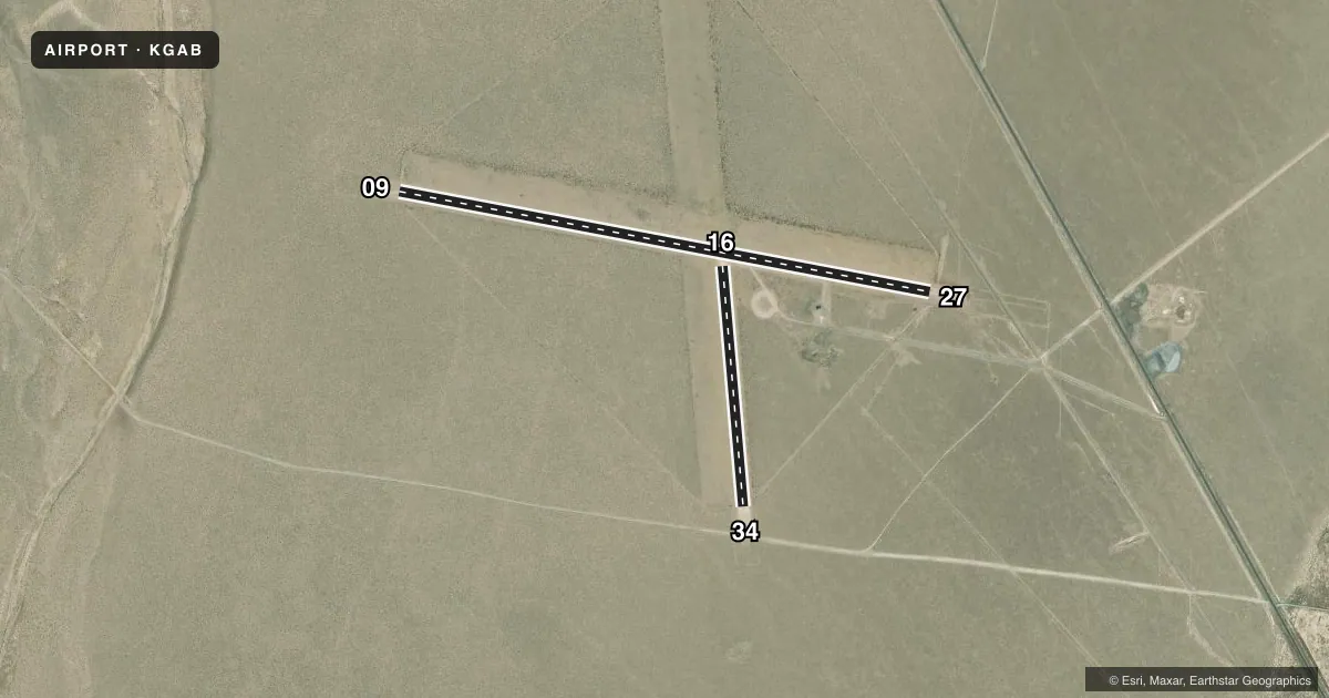
Runways & pattern
Full pagePattern entry · RWY 09
LEFT TRAFFICAirport sketch
Runways drawn to scale from FAA survey coordinates, rendered over satellite imagery. Not for navigation.
Approaches & charts
Services on the field
Fuel grades, oxygen, maintenance, ramp storage and lighting — as declared to the FAA by the airport operator.
Fuel & services
- Fuel
- Not available
- Oxygen (bottled)
- Not available
- Oxygen (bulk)
- Not available
- Airframe repair
- Not available
- Power plant repair
- Not available
Ramp & ground
- Transient storage
- Tie-down
- Landing fee
- No fee published
- Customs
- Not available
- Wind indicator
- Yes
- Segmented circle
- Yes
Fuel & FBOs
Cheapest 100LL and Jet A on the field and nearby. Always confirm with the FBO before taxi.
Airport notes
Surface conditions, obstructions, local procedures, lighting outages and other notes published with each FAA cycle.
General notes
- ARR RWY 09 & DEP RWY 27; WIND PMTG.
- NO LINE OF SIGHT BTN RWY 09/27 & 16/34.
- ARPT UNLGTD.
- FOR CD CTC OAKLAND ARTCC AT 510-745-3380.
- JET ACTV N EDGE OF TFC PAT.
Lighting notes
- OTS INDEFLY.
Runway surface & condition
- 09/27RWY 09 & 27 THR & EDGE MARKED WITH REFLECTORS; RWY 09 & 27 REFLECTIVE RODS 240 FT FM EOR.
- 16/34RWY 16 & 34 THR & EDGE MARKED WITH REFLECTORS; RWY 16 & 34 REFLECTIVE RODS 240 FT FM EOR.
Approach & departure obstructions
- 09REFLECTIVE RODS 240 FT FM EOR.
- 16REFLECTIVE RODS 240 FT FM EOR.
- 27REFLECTIVE RODS 240 FT FM EOR.
- 34REFLECTIVE RODS 240 FT FM EOR.
Other notes
- ESTABD PRIOR TO 5/15/59.
- INDCS R TFC RCMD USING RWY 09 & RWY 16.
- MANAGER775-513-3107
VFR map & nearby airports
VFR sectional. Tap any ICAO chip to open that airport.
Key facts · KGAB
Answer card- ICAO
- KGAB
- Name
- GABBS
- Location
- GABBS, NEVADA
- Elevation
- 4,699.3 ft MSL
- Traffic pattern altitude
- 5,699.3 ft MSL (1,000 AGL)
- Control tower
- Non-towered (use CTAF)
- Total runways
- 2
- Longest runway
- 09/27 · 5,950 ft
- Published ILS approaches
- 0
- Published frequencies
- 1
- Magnetic variation
- 15°
- Current flight rules
- VFR
- Current wind
- 000° at 0 kt
- Favored runway now
- –
KGAB is in Gabbs, Nevada. The field elevation is 4,699.3 ft MSL. It has two dirt runways. The longest is 5,950 ft on 09/27. There is no control tower. No ILS approaches are published. Pattern altitude is not published, so use the standard 1,000 ft AGL for light piston traffic unless the current FAA Chart Supplement says otherwise.
This is an unlighted airport. The beacon is out of service indefinitely. Runway 09 and 27 have reflective threshold and edge markers. Reflective rods are also placed 240 ft from the ends of 09, 27, 16 and 34. The published remarks say arrivals use runway 09. Departures use runway 27 when wind permits. They also note that jet activity occurs near the edge of the traffic pattern. That is worth keeping in mind on a first visit.
There are no on-field FBOs listed. Plan fuel and services with the airport operator or the FBO directly by phone before you go. CTAF is 122.9. For clearance delivery, contact Oakland ARTCC at 510-745-3380. The field has no line of sight between the 09/27 runway and 16/34. That matters for traffic scans and runway selection. If you are flying in at night or in marginal conditions, verify current lighting and operational status with the current FAA Chart Supplement before departure.