METAR & TAF N15
N15 does not publish a METAR.
Showing the nearest reporting station: KTMT (AUSTIN) · 17.0 NM away. Conditions at N15 may differ.
METAR · KTMT
Observed 05:35Z
KTMT 270535Z AUTO 14004KT 10SM CLR 21/00 A3018 RMK AO2 T02121004
- Wind
- 140° @ 4 kt
- Visibility
- 10 SM
- Temp / Dew
- 21°C / 0°C
- Altimeter
- 30.18 inHg
- Clouds
- CLR
- Density alt
- 7,931 ft
- Ceiling
- Unlimited
- Rules
- VFR
Airport info & contacts
Manager on record, flight service, ARTCC, attendance schedule and pattern altitude — published by the FAA and refreshed every 28 days.
Location
- From city
- 2 NM E
- VFR sectional
- LAS VEGAS
- ARTCC
- ZLC · SALT LAKE CITY
- NOTAM facility
- RNO (NOTAM-D)
Airport manager
- Name
- TOM ANDERSEN
- Phone
- 530-615-1346
- Address
- 420 MAIN STREET, NEVADA CITY CA 95959
Flight service · Hours
- FSS RNO
- RENO1-800-WX-BRIEF
- Attendance
- Unattended
Frequencies
Tap any row to copy the frequency to your clipboard.
Runways & pattern
Full pagePattern entry · RWY 16
LEFT TRAFFIC| Runway | Heading (°M) | Length | Surface | Traffic |
|---|---|---|---|---|
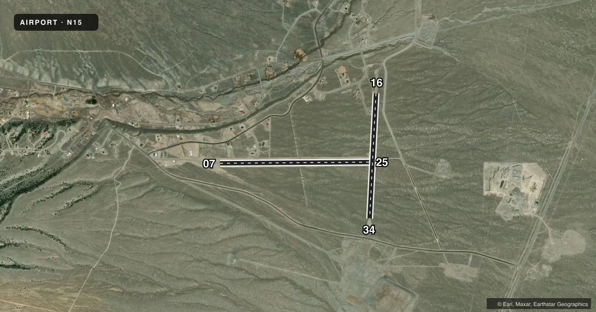
| 07/25 | 75° / 255° | 3,700 ft | GRVL-DIRT | Standard L |
| 16/34Favored | 168° / 348° | 3,072 ft | GRVL-DIRT | 34 R |
Runway end performance
| End | TORA | TODA | ASDA | LDA | VGSI | Approach lights | Obstruction |
|---|---|---|---|---|---|---|---|
| 16 | — | — | — | — | — | — | 48', pline, 985' from thr, 0' R of cntrln, slope 20 |
| 34 | — | — | — | — | — | — | 48', pline, 920' from thr, 0' R of cntrln, slope 19 |
Declared distances in feet. TORA = takeoff run available, TODA = takeoff distance, ASDA = accelerate-stop, LDA = landing distance.
Airport sketch
Runways drawn to scale from FAA survey coordinates, rendered over satellite imagery. Not for navigation.
Approaches & charts
Services on the field
Fuel grades, oxygen, maintenance, ramp storage and lighting — as declared to the FAA by the airport operator.
Fuel & services
- Fuel
- Not available
- Other services
- AMB
Ramp & ground
- Transient storage
- Tie-down
- Beacon schedule
- SS-SR
- Beacon
- White / Green / Yellow (heliport)(WGY)
- Wind indicator
- Yes
- Segmented circle
- Yes
Fuel & FBOs
Cheapest 100LL and Jet A on the field and nearby. Always confirm with the FBO before taxi.
Airport notes
Surface conditions, obstructions, local procedures, lighting outages and other notes published with each FAA cycle.
General notes
- HELI FOR EMS OPS ON ARPT.
- HEL PRKG ON HELI PREFERRED FOR DUST.
- APCH & DEP FM EAST IF ABLE.
- HEL LND RWY 25 & TKOF RWY 07 FOR H1 RCMDD.
- FOR CD CTC SALT LAKE ARTCC AT 801-320-2568.
- CALL AHEAD FOR COND - AMGR.
- FOR HELI BCN & LGTD WINDSOCK - 775-412-3792.
Runway surface & condition
- 07/25SLOPED; RCMD LND RWY 25 & TKOF RWY 7 IN LIGHT WIND.
- H1SS-SR.
Approach & departure obstructions
- 07THLD MKD BY WHITE TIRES.
- 16THLD MKD BY WHITE TIRES.
- 25THLD MKD BY WHITE TIRES.
- 34THLD MKD BY WHITE TIRES.
- H1TLOF MKD BY AMBER REFLECTORS.
Other notes
- PRVDD VFR OPS SHALL BE CONDUCTED.
VFR map & nearby airports
VFR sectional. Tap any ICAO chip to open that airport.
Key facts · N15
Answer card- ICAO
- N15
- Name
- KINGSTON
- Location
- KINGSTON, NEVADA
- Elevation
- 6,075 ft MSL
- Traffic pattern altitude
- 7,075 ft MSL (1,000 AGL)
- Control tower
- Non-towered (use CTAF)
- Total runways
- 2
- Longest runway
- 07/25 · 3,700 ft
- Published ILS approaches
- 0
- Published frequencies
- 1
- Magnetic variation
- 15°
- Current flight rules
- VFR
- Current wind
- 140° at 4 kt
- Favored runway now
- RWY 16
Kingston Airport sits in Kingston, Nevada at 6,075 ft MSL. It has two gravel-dirt runways. The longest is runway 07/25 at 3,700 ft. Runway 16/34 is 3,072 ft. There is no control tower, so plan for CTAF self-announce traffic on 122.9. No ILS approaches are published here.
The pattern altitude is not published. Use the standard 1,000 ft AGL for light piston operations unless the current Chart Supplement says otherwise. This is a high-elevation field, so density altitude will matter on warm days. Expect longer takeoff rolls and reduced climb performance. The published remarks also say approach and departure from the east is preferred if able. Runway 07/25 is sloped. Landing on runway 25 and taking off on runway 7 are recommended in light wind. The threshold markings are white tires.
There are no on-field FBOs listed. If you need fuel or local handling, contact the airport operator directly before you go. Helicopter activity is part of the field use. Helicopter runway H1 is lighted from sunset to sunrise. Helicopter parking on the helipad is preferred to reduce dust. For helicopter beacon and lighted windsock information, call 775-412-3792.