METAR & TAF KTPH
Current METAR
Observed 08:56Z
KTPH 270856Z AUTO 00000KT 10SM CLR 25/M01 A3014 RMK AO2 SLP102 T02501011 58002
- Wind
- 000° @ 0 kt
- Visibility
- 10 SM
- Temp / Dew
- 25°C / -1°C
- Altimeter
- 30.14 inHg
- Clouds
- CLR
- Density alt
- 7,661 ft
- Ceiling
- Unlimited
- Rules
- VFR
Airport info & contacts
Manager on record, flight service, ARTCC, attendance schedule and pattern altitude — published by the FAA and refreshed every 28 days.
Location
- From city
- 7 NM E
- VFR sectional
- LAS VEGAS
- ARTCC
- ZLA · LOS ANGELES
- NOTAM facility
- TPH (NOTAM-D)
Airport manager
- Name
- THOMAS BOLLING
- Phone
- 775-751-6270
- Address
- 2041 E. CALVADA BLVD. N. SUITE #3, PAHRUMP NV 89048
Flight service · Hours
- FSS RNO
- RENO1-800-WX-BRIEF
- Attendance
- 0600-2300
Frequencies
Tap any row to copy the frequency to your clipboard.
Runways & pattern
Full pagePattern entry · RWY 15
LEFT TRAFFIC| Runway | Heading (°M) | Length | Surface | Traffic |
|---|---|---|---|---|
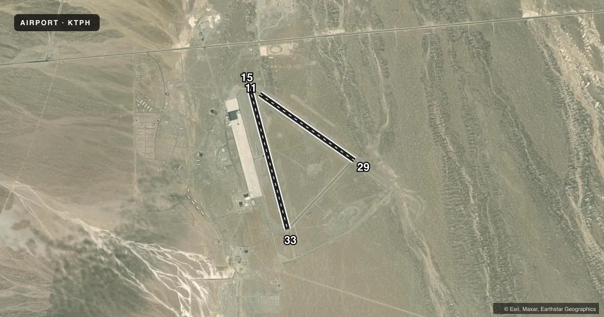
| 15/33 | 150° / 330° | 7,160 ft | ASPH | Standard L |
| 11/29 | 110° / 290° | 5,660 ft | ASPH | Standard L |
Runway end performance
| End | TORA | TODA | ASDA | LDA | VGSI | Approach lights | Obstruction |
|---|---|---|---|---|---|---|---|
| 15 | — | — | — | — | PAPI 2-box left(3°) | — | — |
| 33 | — | — | — | — | VASI 4-box left(3°) | — | — |
Declared distances in feet. TORA = takeoff run available, TODA = takeoff distance, ASDA = accelerate-stop, LDA = landing distance.
Airport sketch
Runways drawn to scale from FAA survey coordinates, rendered over satellite imagery. Not for navigation.
Approaches & charts
Services on the field
Fuel grades, oxygen, maintenance, ramp storage and lighting — as declared to the FAA by the airport operator.
Fuel & services
- Fuel
- 100LLA
- Oxygen (bottled)
- Low pressure
- Oxygen (bulk)
- Not available
- Airframe repair
- Major
- Power plant repair
- Major
- Other services
- AMB
Ramp & ground
- Transient storage
- Tie-down
- Buoy
- Landing fee
- No fee published
- Customs
- Not available
- Lighting schedule
- SEE RMK
- Beacon schedule
- SS-SR
- Beacon
- White / Green (civil land)(WG)
- Wind indicator
- Lighted
- Segmented circle
- Yes
Fuel & FBOs
Cheapest 100LL and Jet A on the field and nearby. Always confirm with the FBO before taxi.
Airport notes
Surface conditions, obstructions, local procedures, lighting outages and other notes published with each FAA cycle.
General notes
- FOR CD, IF UNA TO CTC ON FSS FREQ, CTC NELLIS APCH AT 702-652-4172.
Lighting notes
- ACTVT PAPI RWY 15; MIRL RWY 15/33 & 11/29 - CTAF.
Fuel notes
- 100LLFUEL AVBL 0700-1800; AFT HRS O/R CALL (775) 482-3626.
Approach & departure obstructions
- H1FATO & "H" MARKED IN YELLOW
- H1FADED YELLOW OUTLINE.
Other notes
- ESTABD PRIOR TO 15 MAY 1959.
- OWNEREMERG CTC 775-513-3107.
- OWNEROTR CTC (775) 482-3626.
- 11/29RWY CRACKING FULL-LEN; LATERAL & LONGL CRACKS IN EXCESS OF 4 INCHES.
VFR map & nearby airports
VFR sectional. Tap any ICAO chip to open that airport.
Key facts · KTPH
Answer card- ICAO
- KTPH
- Name
- TONOPAH
- Location
- TONOPAH, NEVADA
- Elevation
- 5,430.3 ft MSL
- Traffic pattern altitude
- 6,430.3 ft MSL (1,000 AGL)
- Control tower
- Non-towered (use CTAF)
- Total runways
- 2
- Longest runway
- 15/33 · 7,160 ft
- Published ILS approaches
- 0
- Published frequencies
- 2
- Magnetic variation
- 15°
- Current flight rules
- VFR
- Current wind
- 000° at 0 kt
- Favored runway now
- –
Tonopah Airport sits in Tonopah, Nevada. The field elevation is 5,430.3 ft MSL. It has two asphalt runways. The longest is runway 15/33 at 7,160 ft. There is no control tower. CTAF and UNICOM are both 123.0. No ILS approaches are published here.
Pattern altitude is not published. Use a standard 1,000 ft AGL pattern unless local procedures or ATC say otherwise. KT Aero is on the field. It carries 100LL and JET A. Call 209-504-4612 for current service details. Published remarks also note medium intensity runway lighting on both runways. Runway 15 has PAPI. Lighting is controlled on CTAF.
This is a high-elevation desert airport, so expect performance to feel different than at lower fields. Check density altitude before departure. Runway 11/29 has a published cracking issue with full-length lateral and longitudinal cracks wider than 4 inches. Use caution and inspect the runway condition in the current Chart Supplement before you go. Fuel is available from 0700 to 1800. After hours, call 775-482-3626 for overrun service. For clearance delivery when Flight Service is not available, contact Nellis Approach at 702-652-4172.