METAR & TAF KMMH
Current METAR
Observed 11:55Z
KMMH 271155Z AUTO 00000KT 10SM CLR 10/M01 A3029 RMK AO2
- Wind
- 000° @ 0 kt
- Visibility
- 10 SM
- Temp / Dew
- 10°C / -1°C
- Altimeter
- 30.29 inHg
- Clouds
- CLR
- Density alt
- 7,788 ft
- Ceiling
- Unlimited
- Rules
- VFR
Airport info & contacts
Manager on record, flight service, ARTCC, attendance schedule and pattern altitude — published by the FAA and refreshed every 28 days.
Location
- From city
- 6 NM E
- VFR sectional
- SAN FRANCISCO
- Pattern altitude
- 872 ft AGL · 8,007 ft MSL
- ARTCC
- ZOA · OAKLAND
- NOTAM facility
- MMH (NOTAM-D)
Airport manager
- Name
- SOIBIAN SPRING
- Phone
- 760-914-0065
- Address
- PO BOX 1609, MAMMOTH LAKES CA 93546
Flight service · Hours
- FSS RAL
- RIVERSIDE1-800-WX-BRIEF
- Attendance
- 0800-1630
Frequencies
Tap any row to copy the frequency to your clipboard.
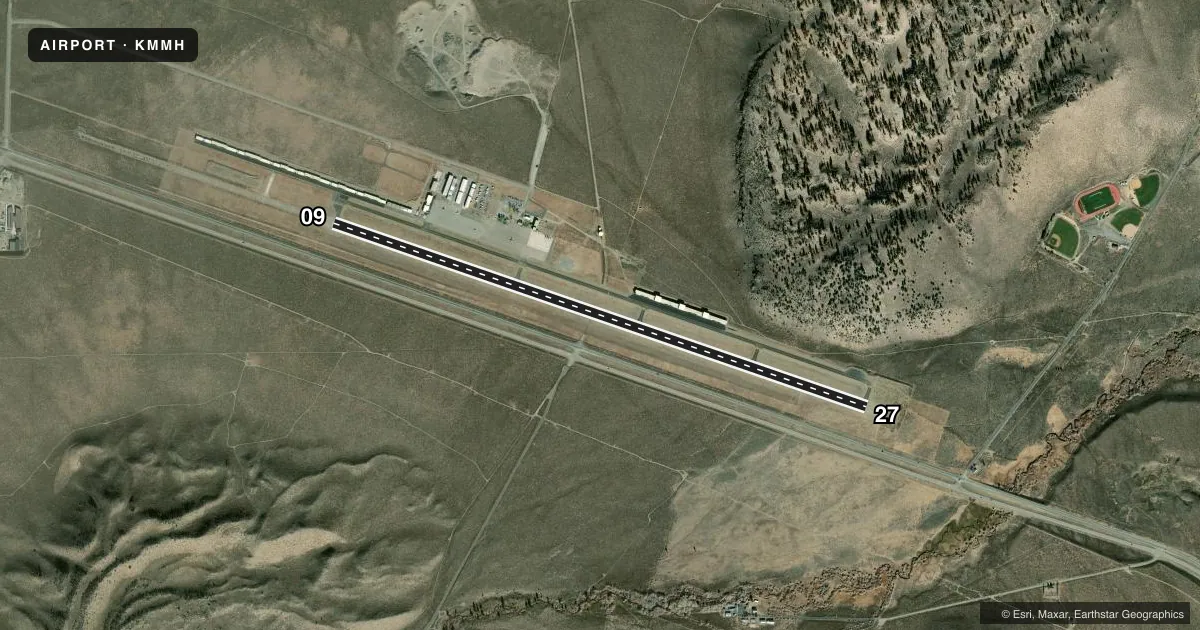
Runways & pattern
Full pagePattern entry · RWY 09
LEFT TRAFFICRunway end performance
| End | TORA | TODA | ASDA | LDA | VGSI | Approach lights | Obstruction |
|---|---|---|---|---|---|---|---|
| 09 | 7,000' | 7,000' | 7,000' | 7,000' | — | — | — |
| 27 | 7,000' | 7,000' | 7,000' | 7,000' | PAPI 4-box left(3°) | — | — |
Declared distances in feet. TORA = takeoff run available, TODA = takeoff distance, ASDA = accelerate-stop, LDA = landing distance.
Airport sketch
Runways drawn to scale from FAA survey coordinates, rendered over satellite imagery. Not for navigation.
Approaches & charts
Services on the field
Fuel grades, oxygen, maintenance, ramp storage and lighting — as declared to the FAA by the airport operator.
Fuel & services
- Fuel
- 100LLA
- Oxygen (bulk)
- High pressure
- Airframe repair
- Not available
- Power plant repair
- Not available
Ramp & ground
- Transient storage
- Tie-down
- Hangar
- Landing fee
- No fee published
- Customs
- Not available
- Lighting schedule
- SEE RMK
- Beacon schedule
- SS-SR
- Beacon
- White / Green (civil land)(WG)
- Wind indicator
- Yes
- Segmented circle
- Yes
Fuel & FBOs
Cheapest 100LL and Jet A on the field and nearby. Always confirm with the FBO before taxi.
Airport notes
Surface conditions, obstructions, local procedures, lighting outages and other notes published with each FAA cycle.
General notes
- RIDGE 3 NM FM APCH END RWY 09.
- RIDGE AT RWY 27 IS 304 FT ABOVE RWY & 1200 FT NORTH OF CNTRLN WITH HAZARD BEACONS.
- ARPT LCTD IN MOUNTAINOUS TERRAIN WITH OCNL STRONG WINDS AND TURBULENCE. LGTD WINDSOCK AVBL AT RY ENDS AND CENTERFIELD; WITH SOUTHERLY CROSSWINDS IN EXCESS OF 15 KNOTS; EXPC TURBULENCE AND PSBL WINDSHEAR ALONG FIRST 3000 FT OF RY 27.
- NIGHT FLYING NOT RECOMMENDED WITHOUT KNOWLEDGE OF LOCAL TERRAIN.
- NOISE ABATEMENT: ACFT ARR FM THE SOUTH, OR DEP TO THE SOUTH REMAIN EAST OF HWY 395.
- NO SNOW REMOVAL DRG NGT HRS (1630-0700L) WO PRIOR PMSN.
- 33 FT POLE LCTD 400 FT WEST OF APCH END OF RY 27 AND 375 FT SOUTH OF RY 27 CENTERLINE MARKED WITH OBSTRUCTION LIGHT.
- LDG FEES.
- APCH REF CODE B/III/5000, DEP REF CODE B/III.
- FOR CD IF UNA TO CTC ON FSS FREQ, CTC OAKLAND ARTCC AT 510-745-3380.
Lighting notes
- ACTVT REIL RWY 27; MIRL RWY 09/27 - CTAF.
Fuel notes
- 100LL100LL FUEL AVBL 24 HRS; CARD LOCK SYSTEM.
Runway surface & condition
- 09/27PCR VALUE: 370/F/C/X/T
Other notes
- CLSD TO ACR OPNS OF CHTR OPNS, BUS JET OPNS, AND SKEDD COML OPNS OF ACR WITH MORE THAN 30 PSGRS AND/OR WINGSPANS GTR THAN 79 FEET EXCP 24 HR PPR. CALL AMGR 760-965-3654.
VFR map & nearby airports
VFR sectional. Tap any ICAO chip to open that airport.
Key facts · KMMH
Answer card- ICAO
- KMMH
- Name
- MAMMOTH YOSEMITE
- Location
- MAMMOTH LAKES, CALIFORNIA
- Elevation
- 7,134.8 ft MSL
- Traffic pattern altitude
- 8,006.8 ft MSL (872 AGL)
- Control tower
- Non-towered (use CTAF)
- Total runways
- 1
- Longest runway
- 09/27 · 7,000 ft
- Published ILS approaches
- 0
- Published frequencies
- 2
- Magnetic variation
- 15°
- Current flight rules
- VFR
- Current wind
- 000° at 0 kt
- Favored runway now
- –
Mammoth Yosemite Airport sits in Mammoth Lakes, California. The field elevation is 7,134.8 ft MSL. It has one runway, 09/27, which is 7,000 ft long. There is no control tower. CTAF and UNICOM are both 122.8. No ILS approaches are published here.
Pattern altitude is 872 ft AGL, which is 8,006.8 ft MSL. Hot Creek Aviation is on the field. It carries 100LL, Jet A and Jet A Prist. 100LL is available 24 hours with a card lock system. That matters here because the airport sits high in the mountains. Night flying is not recommended without local terrain knowledge. The published remarks also call out terrain near both runway ends. There is a ridge near the approach end of runway 09. Runway 27 has a ridge north of the centerline with hazard beacons. There is also a marked pole west of the approach end.
Noise abatement is specific. Arrivals from the south or departures to the south should stay east of Highway 395. Landing fees apply. The airport also restricts some charter, business jet and scheduled commercial operations unless prior permission is obtained from the airport manager. For a first trip, review the current FAA Chart Supplement before you go. The field is a mountain airport with real terrain and lighting considerations.