METAR & TAF 74P
74P does not publish a METAR.
Showing the nearest reporting station: KVGT (NORTH LAS VEGAS) · 39.0 NM away. Conditions at 74P may differ.
METAR · KVGT
Observed 08:53Z
KVGT 270853Z AUTO 20006KT 10SM CLR 36/08 A2986 RMK AO2 SLP090 T03560078 58000
- Wind
- 200° @ 6 kt
- Visibility
- 10 SM
- Temp / Dew
- 36°C / 8°C
- Altimeter
- 29.86 inHg
- Clouds
- CLR
- Density alt
- 5,975 ft
- Ceiling
- Unlimited
- Rules
- VFR
Airport info & contacts
Manager on record, flight service, ARTCC, attendance schedule and pattern altitude — published by the FAA and refreshed every 28 days.
Location
- From city
- 5 NM N
- VFR sectional
- LAS VEGAS
- ARTCC
- ZLA · LOS ANGELES
- NOTAM facility
- RNO
Airport manager
- Name
- LEE PHILLIPS
- Phone
- 760-608-2765
- Address
- 900 E JENNY CIRCLE, PAHRUMP NV 89060
Flight service · Hours
- FSS RNO
- RENO1-800-WX-BRIEF
- Attendance
- Unattended
Frequencies
Tap any row to copy the frequency to your clipboard.
Runways & pattern
Full pagePattern entry · RWY 15
LEFT TRAFFICRunway end performance
| End | TORA | TODA | ASDA | LDA | VGSI | Approach lights | Obstruction |
|---|---|---|---|---|---|---|---|
| 15 | — | — | — | — | — | — | 35', pline, 375' from thr |
| 33 | — | — | — | — | — | — | 12', bldg, 400' from thr |
Declared distances in feet. TORA = takeoff run available, TODA = takeoff distance, ASDA = accelerate-stop, LDA = landing distance.
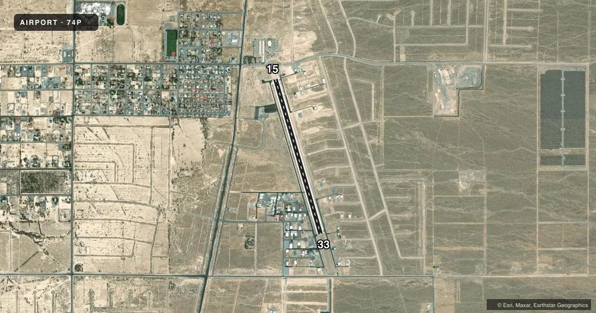
Airport sketch
Runways drawn to scale from FAA survey coordinates, rendered over satellite imagery. Not for navigation.
Approaches & charts
Services on the field
Fuel grades, oxygen, maintenance, ramp storage and lighting — as declared to the FAA by the airport operator.
Fuel & services
- Fuel
- 100LLAA+
- Oxygen (bottled)
- Not available
- Oxygen (bulk)
- Not available
- Airframe repair
- Not available
- Power plant repair
- Not available
- Other services
- INSTR
Ramp & ground
- Transient storage
- Tie-down
- Landing fee
- No fee published
- Lighting schedule
- SEE RMK
- Wind indicator
- Yes
- Segmented circle
- No
Fuel & FBOs
Cheapest 100LL and Jet A on the field and nearby. Always confirm with the FBO before taxi.
Airport notes
Surface conditions, obstructions, local procedures, lighting outages and other notes published with each FAA cycle.
General notes
- OTR CTC LEE PHILLIPS 760-603-7512.
- TSNT ACFT PRKG OFF NW PARL TWY AT TRML.
- PPR FOR ACFT OPRNS OVER 12500 LBS, COML OPRNS, AND FOR GLDR, PWRD PRCHT, BANNER TOWING, PRCHTG, FLT TRNG, UAS, OR JET OPRNS.
- ACFT WINGSPANS EXCEEDING GROUP I (49 FT) RSTRD NW PARL TWY AND ALL TAXILANES.
- FOR CD CTC LOS ANGELES ARTCC AT 661-575-2079.
- HVY ACFT PRKG NW CORNER.
Lighting notes
- ACTVT LIRL RWY 15/33 - CTAF 5 CLICKS.
Approach & departure obstructions
- 15RWY MARKINGS FADED.
- 33RWY MARKINGS FADED.
Other notes
- TIE DOWNS SOUTH OF RWY NEAR TRML BLDG.
VFR map & nearby airports
VFR sectional. Tap any ICAO chip to open that airport.
Key facts · 74P
Answer card- ICAO
- 74P
- Name
- CALVADA MEADOWS
- Location
- PAHRUMP, NEVADA
- Elevation
- 2,726 ft MSL
- Traffic pattern altitude
- 3,726 ft MSL (1,000 AGL)
- Control tower
- Non-towered (use CTAF)
- Total runways
- 1
- Longest runway
- 15/33 · 4,081 ft
- Published ILS approaches
- 0
- Published frequencies
- 2
- Magnetic variation
- 14°
- Current flight rules
- VFR
- Current wind
- 200° at 6 kt
- Favored runway now
- RWY 15
Calvada Meadows Airport (74P) sits in Pahrump, Nevada. Field elevation is 2,726 ft MSL. The airport has one runway. Runway 15/33 is 4,081 ft long with asphalt and gravel surface. The airport is not towered. CTAF and UNICOM are both 122.8. No ILS approaches are published here.
Pattern altitude is not published. Use the standard 1,000 ft AGL pattern unless the current Chart Supplement says otherwise. That puts the light piston pattern at 3,726 ft MSL. The Airport Club is on the field. It carries 100LL and Jet A. Call ahead at (775) 764-1281 if you need current fuel or ramp details.
A few published remarks matter here. Runway 15 and 33 markings are faded. Low intensity runway lights on 15/33 come on with five clicks on CTAF. Aircraft over 49 ft wingspan are restricted from the northwest parallel taxiway and all taxilanes. Clearance delivery is handled through Los Angeles ARTCC at 661-575-2079. The field also has prior permission requirements for operations over 12,500 lb, commercial use, glider, powered parachute, banner towing, parachuting, flight training, unmanned aircraft systems and jet operations. For a first visit, plan for an uncontrolled field. Confirm taxi parking on the northwest side. Verify any special-use permission before arrival.