METAR & TAF 0L7
0L7 does not publish a METAR.
Showing the nearest reporting station: KHND (HENDERSON EXEC) · 15.5 NM away. Conditions at 0L7 may differ.
METAR · KHND
Observed 08:56Z
KHND 270856Z AUTO 21011KT 10SM CLR 34/09 A2992 RMK AO2 SLP107 T03440089 58001 $
- Wind
- 210° @ 11 kt
- Visibility
- 10 SM
- Temp / Dew
- 34°C / 9°C
- Altimeter
- 29.92 inHg
- Clouds
- CLR
- Density alt
- 5,795 ft
- Ceiling
- Unlimited
- Rules
- VFR
Airport info & contacts
Manager on record, flight service, ARTCC, attendance schedule and pattern altitude — published by the FAA and refreshed every 28 days.
Location
- From city
- 1 NM S
- VFR sectional
- LAS VEGAS
- Pattern altitude
- 800 ft AGL · 3,635 ft MSL
- ARTCC
- ZLA · LOS ANGELES
- NOTAM facility
- RNO (NOTAM-D)
Airport manager
- Name
- BRUCE DAUGHERTY
- Phone
- 702-261-4802
- Address
- 3500 EXECUTIVE TERMINAL DR, HENDERSON NV 89052
Flight service · Hours
- FSS RNO
- RENO1-800-WX-BRIEF
- Attendance
- Unattended
Frequencies
Tap any row to copy the frequency to your clipboard.
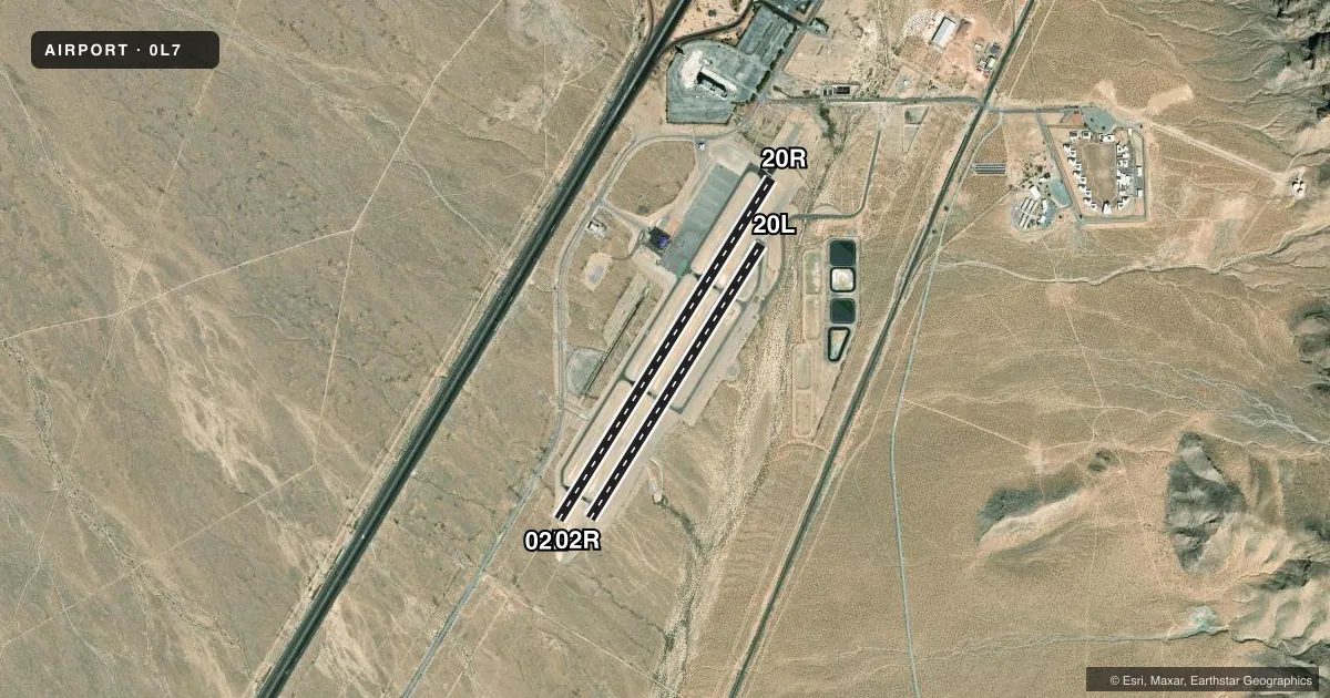
Runways & pattern
Full pagePattern entry · RWY 20R
RIGHT TRAFFIC| Runway | Heading (°M) | Length | Surface | Traffic |
|---|---|---|---|---|
| 02L/20RFavored | 18° / 198° | 4,600 ft | ASPH | 20R R |
| 02R/20L | 18° / 198° | 3,700 ft | ASPH | 02R R |
Runway end performance
| End | TORA | TODA | ASDA | LDA | VGSI | Approach lights | Obstruction |
|---|---|---|---|---|---|---|---|
| 02L | — | — | — | — | — | — | 30', pole, 1230' from thr, 180' R of cntrln, slope 34 |
| 20R | — | — | — | — | — | — | 15', road, 830' from thr, 0' R of cntrln, slope 42 |
| 20L | — | — | — | — | — | — | 85', pole, 1940' from thr, 510' R of cntrln, slope 20 |
Declared distances in feet. TORA = takeoff run available, TODA = takeoff distance, ASDA = accelerate-stop, LDA = landing distance.
Airport sketch
Runways drawn to scale from FAA survey coordinates, rendered over satellite imagery. Not for navigation.
Approaches & charts
Services on the field
Fuel grades, oxygen, maintenance, ramp storage and lighting — as declared to the FAA by the airport operator.
Fuel & services
- Fuel
- 100LLA
- Other services
- AMB,GLD,INSTR,PAJA,TOW
Ramp & ground
- Transient storage
- Tie-down
- Landing fee
- No fee published
- Customs
- Not available
- Lighting schedule
- SEE RMK
- Beacon schedule
- SS-SR
- Beacon
- White / Green (civil land)(WG)
- Wind indicator
- Yes
- Segmented circle
- Yes
Fuel & FBOs
Cheapest 100LL and Jet A on the field and nearby. Always confirm with the FBO before taxi.
Airport notes
Surface conditions, obstructions, local procedures, lighting outages and other notes published with each FAA cycle.
General notes
- PWR ACFT PRKG W OF FLD; GLDR PRKG E OF FLD.
- PWR ACFT ENTRY FM W; USE TFC PAT W OF RWY.
- SKYDIVING DROP ZONE 4 MI S; AEROBATIC ACT 2 MI W; ULTRALIGHT ACT ON ARPT.
- GLDR ACT 12000 FT MSL & BLW INVOF ARPT.
- FOR CD CTC LAS VEGAS APCH AT 725-200-4432.
Lighting notes
- ACTVT MIRL RWY 02L/20R - CTAF.
Fuel notes
- 100LL24 HR SELF SVC FUEL.
Other notes
- ESTABD PRIOR TO 15 MAY 1959.
- MANAGERJUSTIN DI AMBROSIO - 702-261-4851
VFR map & nearby airports
VFR sectional. Tap any ICAO chip to open that airport.
Key facts · 0L7
Answer card- ICAO
- 0L7
- Name
- JEAN
- Location
- JEAN, NEVADA
- Elevation
- 2,835 ft MSL
- Traffic pattern altitude
- 3,635 ft MSL (800 AGL)
- Control tower
- Non-towered (use CTAF)
- Total runways
- 2
- Longest runway
- 02L/20R · 4,600 ft
- Published ILS approaches
- 0
- Published frequencies
- 1
- Magnetic variation
- 14°
- Current flight rules
- VFR
- Current wind
- 210° at 11 kt
- Favored runway now
- RWY 20R
JEAN (0L7) is in Jean, Nevada. The field elevation is 2,835 ft MSL. It has two asphalt runways. The longest is 4,600 ft. There is no control tower. CTAF is 122.9. No ILS approaches are published. Pattern altitude is 800 ft AGL, which is 3,635 ft MSL.
Jean Airport is on the field. It carries 100LL and Jet A. 24-hour self-serve fuel is available. The published remarks also note medium intensity runway lights on runway 02L/20R. They are activated by CTAF. That matters after dark. Powered aircraft enter from the west and use the traffic pattern west of the runway. Glider activity is common in the area. The remarks also call out skydiving 4 miles south, aerobatic activity 2 miles west and ultralight activity on the airport.
This is a non-towered desert airport with mixed traffic. Plan for close self-announce discipline. The field sits in the Las Vegas area. Check the current FAA Chart Supplement for any noise or curfew restrictions before flying into the field. For clearance delivery, the published contact is Las Vegas Approach. If you are new to the airport, verify the current pattern flow and any local operating notes before arrival.