METAR & TAF 0O2
0O2 does not publish a METAR.
Showing the nearest reporting station: KDAG (BARSTOW-DAGGETT) · 43.3 NM away. Conditions at 0O2 may differ.
METAR · KDAG
Observed 09:50Z
KDAG 270950Z AUTO 30012KT 10SM CLR 29/04 A2992 RMK AO2 SLP099 T02890044 $
- Wind
- 300° @ 12 kt
- Visibility
- 10 SM
- Temp / Dew
- 29°C / 4°C
- Altimeter
- 29.92 inHg
- Clouds
- CLR
- Density alt
- 2,823 ft
- Ceiling
- Unlimited
- Rules
- VFR
Airport info & contacts
Manager on record, flight service, ARTCC, attendance schedule and pattern altitude — published by the FAA and refreshed every 28 days.
Location
- From city
- 2 NM NW
- VFR sectional
- LOS ANGELES
- ARTCC
- ZLA · LOS ANGELES
- NOTAM facility
- RAL (NOTAM-D)
Airport manager
- Name
- TESS COOK
- Phone
- 909-327-8740
- Address
- 21600 CORWIN ROAD, APPLE VALLEY CA 92307
Flight service · Hours
- FSS RAL
- RIVERSIDE1-800-WX-BRIEF
- Attendance
- Unattended
Frequencies
Tap any row to copy the frequency to your clipboard.
Runways & pattern
Full pagePattern entry · RWY 33
RIGHT TRAFFICRunway end performance
| End | TORA | TODA | ASDA | LDA | VGSI | Approach lights | Obstruction |
|---|---|---|---|---|---|---|---|
| 33 | — | — | — | — | — | — | 80', pline, 1925' from thr, 94' R of cntrln, slope 21 |
Declared distances in feet. TORA = takeoff run available, TODA = takeoff distance, ASDA = accelerate-stop, LDA = landing distance.
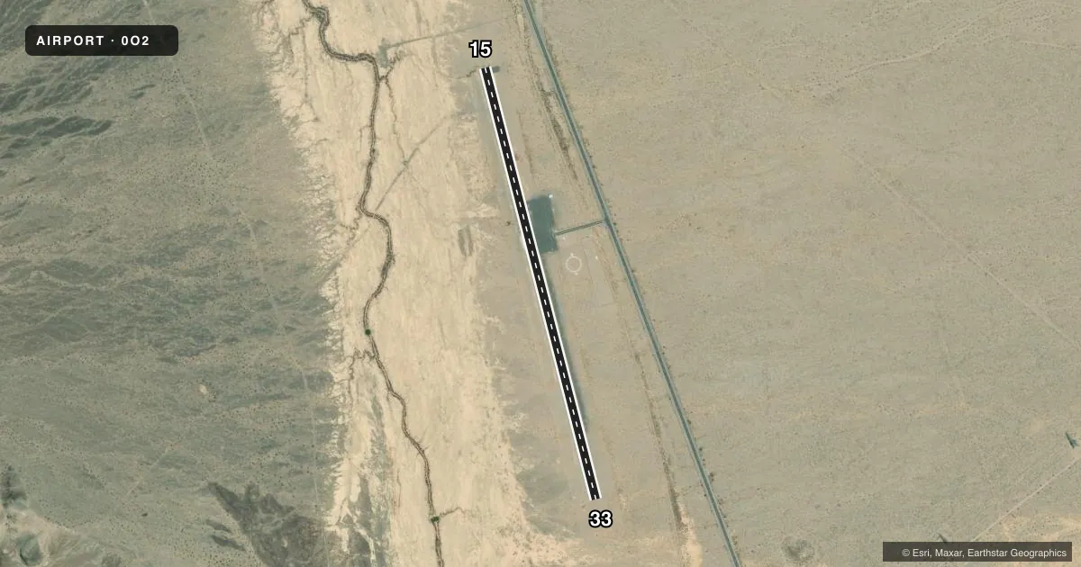
Airport sketch
Runways drawn to scale from FAA survey coordinates, rendered over satellite imagery. Not for navigation.
Approaches & charts
Services on the field
Fuel grades, oxygen, maintenance, ramp storage and lighting — as declared to the FAA by the airport operator.
Fuel & services
- Fuel
- Not available
- Oxygen (bottled)
- Not available
- Oxygen (bulk)
- Not available
- Airframe repair
- Not available
- Power plant repair
- Not available
Ramp & ground
- Transient storage
- Tie-down
- Landing fee
- No fee published
- Customs
- Not available
- Lighting schedule
- SEE RMK
- Beacon schedule
- SS-SR
- Beacon
- White / Green (civil land)(WG)
- Wind indicator
- Lighted
- Segmented circle
- Yes
Fuel & FBOs
Cheapest 100LL and Jet A on the field and nearby. Always confirm with the FBO before taxi.
Airport notes
Surface conditions, obstructions, local procedures, lighting outages and other notes published with each FAA cycle.
General notes
- MOUNTAIN 1/2 MI W ARPT.
- PUBLIC PHONE AT ARPT ACCESS.
- FOR CD CTC LOS ANGELES ARTCC AT 661-575-2079.
Lighting notes
- ACTIVATE MIRL RY 15/33 CTAF.
Other notes
- MANAGERAMGR OFFICE LCTD AT APPLE VALLEY AIRPORT.
- OWNERON LEASE TO COUNTY OF SAN BERNARDINO.
VFR map & nearby airports
VFR sectional. Tap any ICAO chip to open that airport.
Key facts · 0O2
Answer card- ICAO
- 0O2
- Name
- BAKER
- Location
- BAKER, CALIFORNIA
- Elevation
- 922 ft MSL
- Traffic pattern altitude
- 1,922 ft MSL (1,000 AGL)
- Control tower
- Non-towered (use CTAF)
- Total runways
- 1
- Longest runway
- 15/33 · 3,157 ft
- Published ILS approaches
- 0
- Published frequencies
- 1
- Magnetic variation
- 14°
- Current flight rules
- VFR
- Current wind
- 300° at 12 kt
- Favored runway now
- RWY 33
Baker Airport (0O2) sits in Baker, California. The field elevation is 922 ft MSL. It has one runway. Runway 15/33 is 3,157 ft long with asphalt pavement. The airport is not towered. CTAF is 122.9.
No ILS approaches are published here. Pattern altitude is not published, so use the standard 1,000 ft AGL for light piston traffic unless the current Chart Supplement says otherwise. The runway lights on 15/33 can be activated from CTAF. That is useful after sunset or if you are arriving late.
There are no on-field FBOs listed in the facts, so plan ahead for services before you go. A public phone is available at the airport access. For clearance delivery, contact Los Angeles ARTCC at 661-575-2079. The airport is on lease to San Bernardino County. The airport manager’s office is at Apple Valley Airport.
One item to keep in mind is terrain. There is a mountain about half a mile west of the airport. That makes local awareness important on departure and arrival. Check the current FAA Chart Supplement for any published noise or operational notes before you fly in.