METAR & TAF KPAN
Current METAR
Observed 04:55Z
KPAN 270455Z AUTO 01002KT 10SM SCT060 24/16 A3023 RMK AO2
- Wind
- 010° @ 2 kt
- Visibility
- 10 SM
- Temp / Dew
- 24°C / 16°C
- Altimeter
- 30.23 inHg
- Clouds
- SCT
- Density alt
- 7,094 ft
- Ceiling
- Unlimited
- Rules
- VFR
Airport info & contacts
Manager on record, flight service, ARTCC, attendance schedule and pattern altitude — published by the FAA and refreshed every 28 days.
Location
- From city
- 1 NM W
- VFR sectional
- PHOENIX
- ARTCC
- ZAB · ALBUQUERQUE
- NOTAM facility
- PRC (NOTAM-D)
Airport manager
- Name
- DENNIS DUEKER
- Phone
- 928--978-6684
- Address
- 806 W. AIRPORT RD, PAYSON AZ 85541
Flight service · Hours
- FSS PRC
- PRESCOTT1-800-WX-BRIEF
- Attendance
- MON-FRI · 0700-1600
- SAT-SUN · 0700-1100
Frequencies
Tap any row to copy the frequency to your clipboard.
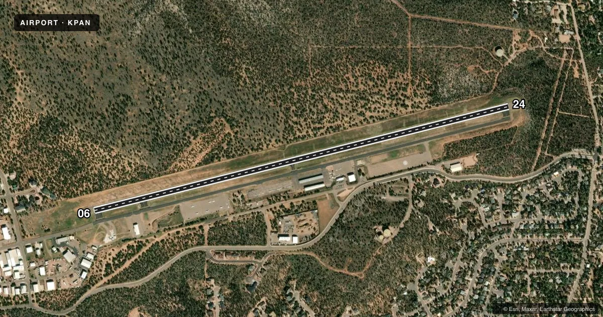
Runways & pattern
Full pagePattern entry · RWY 06
LEFT TRAFFICRunway end performance
| End | TORA | TODA | ASDA | LDA | VGSI | Approach lights | Obstruction |
|---|---|---|---|---|---|---|---|
| 06 | — | — | — | — | PAPI 2-box right(3°) | — | — |
| 24 | — | — | — | — | PAPI 2-box left(3°) | — | — |
Declared distances in feet. TORA = takeoff run available, TODA = takeoff distance, ASDA = accelerate-stop, LDA = landing distance.
Airport sketch
Runways drawn to scale from FAA survey coordinates, rendered over satellite imagery. Not for navigation.
Approaches & charts
Services on the field
Fuel grades, oxygen, maintenance, ramp storage and lighting — as declared to the FAA by the airport operator.
Fuel & services
- Fuel
- 100LLA+
- Airframe repair
- Major
- Power plant repair
- Major
- Other services
- AMB,AVNCS,INSTR,RNTL
Ramp & ground
- Transient storage
- Tie-down
- Landing fee
- No fee published
- Customs
- Not available
- Lighting schedule
- SEE RMK
- Beacon schedule
- SS-SR
- Beacon
- White / Green (civil land)(WG)
- Wind indicator
- Lighted
- Segmented circle
- Yes
Fuel & FBOs
Cheapest 100LL and Jet A on the field and nearby. Always confirm with the FBO before taxi.
Airport notes
Surface conditions, obstructions, local procedures, lighting outages and other notes published with each FAA cycle.
General notes
- DEP NOISE ABATEMENT PROC IN EFCT; TURN N 30 DEG FOR 2 NM. ARR/DEP BLW 1000 FT OVR TOWN NA.
- SELF SVC CREDIT CARD FUEL W END; FOLLOW SIGNS - 928-970-0887.
- 150 FT BLAST PADS RWY 06 & 24.
- ARPT CAMPGROUND NEAR BRAVO RAMP.
Lighting notes
- DUSK-DAWN: ACTVT REIL RWY 06 & 24; PAPI RWY 06; MIRL RWY 06/24 - CTAF. MIRL RWY 06/24 PRESET LOW INTST; INCR INTST- CTAF. PAPI RWY 24 OPR CONSLY.
Runway surface & condition
- 06/24RWY 24 CALM WIND RWY LESS THAN 5 KTS.
Approach & departure obstructions
- 062-4 FT BERM 0-150 FT FM THR 85-125 FT L OF CNTRLN.
- 243 FT BRUSH 180 FT FM RWY ACRS THR; 2 FT BRUSH 20-170 FT FM THR 80-125 FT L OF CNTRLN.
Other notes
- TPA PROP ENGINE 1043 FT, JET/MULTI-ENGINE & LARGE ENGINE 1543 FT, HEL 543 FT.
VFR map & nearby airports
VFR sectional. Tap any ICAO chip to open that airport.
Key facts · KPAN
Answer card- ICAO
- KPAN
- Name
- PAYSON
- Location
- PAYSON, ARIZONA
- Elevation
- 5,160.4 ft MSL
- Traffic pattern altitude
- 6,160.4 ft MSL (1,000 AGL)
- Control tower
- Non-towered (use CTAF)
- Total runways
- 1
- Longest runway
- 06/24 · 5,504 ft
- Published ILS approaches
- 0
- Published frequencies
- 2
- Magnetic variation
- 12°
- Current flight rules
- VFR
- Current wind
- 010° at 2 kt
- Favored runway now
- RWY 06
KPAN is in Payson, Arizona. The field elevation is 5,160.4 ft MSL. It has one asphalt runway, 06/24, at 5,504 ft. There is no control tower. CTAF and UNICOM are both 122.8. No ILS approaches are published here.
The published pattern altitude is not standard across all aircraft. Use 1,043 ft AGL for propeller aircraft. Use 1,543 ft AGL for jets, multi-engine and large engine aircraft. Use 543 ft AGL for helicopters. That matters here because the airport sits high enough that performance planning deserves attention. That is especially true on warm days.
MPG East is on the field. It carries 100LL and Jet A. Self-serve credit card fuel is available at the west end. The published remarks also note an airport campground near the Bravo ramp. Runway lighting is pilot-controlled on CTAF from dusk to dawn. The runway end identifier lights are active on 06 and 24. The PAPI on 06 is available. The PAPI on 24 operates continuously.
For first-time arrivals, pay close attention to the departure noise abatement. Turn north 30 degrees for 2 NM after takeoff. Arrival and departure below 1,000 ft over town is not authorized. There are also published obstructions near both thresholds. Check the current FAA Chart Supplement before you go. Brief the runway and terrain picture before descent.