METAR & TAF KFFZ
Current METAR
Observed 05:54Z
KFFZ 270554Z AUTO 26008KT 10SM CLR 38/16 A2985 RMK AO2 SLP077 T03830156 10417 20383 51010 $
- Wind
- 260° @ 8 kt
- Visibility
- 10 SM
- Temp / Dew
- 38°C / 16°C
- Altimeter
- 29.85 inHg
- Clouds
- CLR
- Density alt
- 4,575 ft
- Ceiling
- Unlimited
- Rules
- VFR
Airport info & contacts
Manager on record, flight service, ARTCC, attendance schedule and pattern altitude — published by the FAA and refreshed every 28 days.
Location
- From city
- 5 NM NE
- VFR sectional
- PHOENIX
- Pattern altitude
- 1,308 ft AGL · 2,702 ft MSL
- ARTCC
- ZAB · ALBUQUERQUE
- NOTAM facility
- FFZ (NOTAM-D)
Airport manager
- Name
- CORINNE NYSTROM
- Phone
- 480-644-2450
- Address
- 4800 E FALCON DR., MESA AZ 85215
Flight service · Hours
- FSS PRC
- PRESCOTT1-800-WX-BRIEF
- Attendance
- AUG 16 - MAY 14 · FRI-SUN · 0530-1600
- AUG 16 - MAY 14 · MON-THUR · 0530-1800
- MAY 15 - AUG 15 · FRI-SUN · 0500-1530
- MAY 15 - AUG 15 · MON-THUR · 0500-1800
Frequencies
Tap any row to copy the frequency to your clipboard.
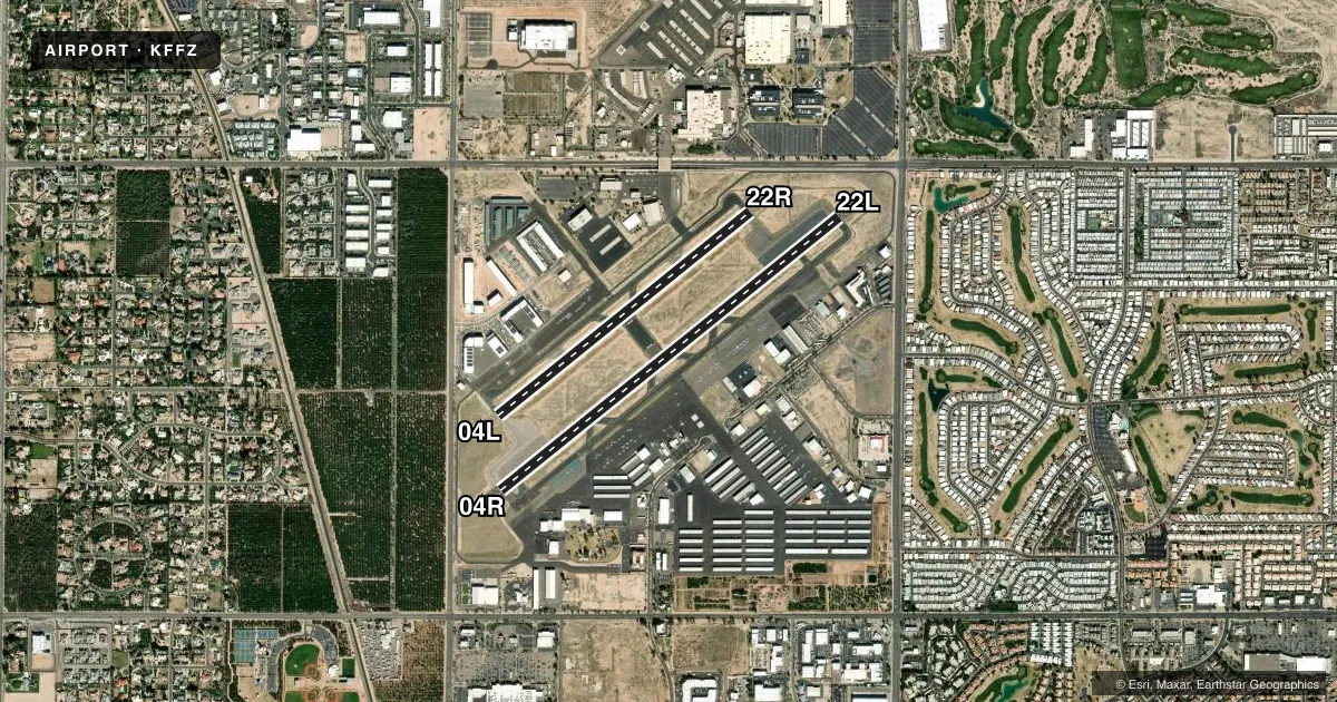
Runways & pattern
Full pagePattern entry · RWY 22L
LEFT TRAFFIC| Runway | Heading (°M) | Length | Surface | Traffic |
|---|---|---|---|---|
| 04R/22LFavored | 39° / 219° | 5,100 ft | ASPH | Standard L |
| 04L/22R | 39° / 219° | 3,799 ft | ASPH | 22R R |
Runway end performance
| End | TORA | TODA | ASDA | LDA | VGSI | Approach lights | Obstruction |
|---|---|---|---|---|---|---|---|
| 04R | — | — | — | — | PAPI 4-box left(4°) | — | 8', road, 420' from thr, 270' R of cntrln, slope 27 |
| 22L | — | — | — | — | PAPI 4-box left(4°) | — | — |
| 04L | — | — | — | — | PAPI 2-box left(4°) | — | — |
| 22R | — | — | — | — | PAPI 2-box left(4°) | — | — |
Declared distances in feet. TORA = takeoff run available, TODA = takeoff distance, ASDA = accelerate-stop, LDA = landing distance.
Airport sketch
Runways drawn to scale from FAA survey coordinates, rendered over satellite imagery. Not for navigation.
Approaches & charts
Services on the field
Fuel grades, oxygen, maintenance, ramp storage and lighting — as declared to the FAA by the airport operator.
Fuel & services
- Fuel
- 100LLAA1+
- Oxygen (bottled)
- HIGH/LOW
- Oxygen (bulk)
- HIGH/LOW
- Airframe repair
- Major
- Power plant repair
- Major
- Other services
- AMB,AVNCS,CHTR,INSTR,RNTL,SALES
Ramp & ground
- Transient storage
- Tie-down
- Landing fee
- No fee published
- Customs
- Not available
- Lighting schedule
- SEE RMK
- Beacon schedule
- SS-SR
- Beacon
- White / Green (civil land)(WG)
- Wind indicator
- Lighted
- Segmented circle
- Yes
Fuel & FBOs
Cheapest 100LL and Jet A on the field and nearby. Always confirm with the FBO before taxi.
Airport notes
Surface conditions, obstructions, local procedures, lighting outages and other notes published with each FAA cycle.
General notes
- 2786 FT MSL UNLGTD MT 5 MI E. RISING TRRN NE.
- TURB PSBL BLW 500 FT NEAR TEST SITE 1.5 MI N.
- TRML APRON LMTD TO 45000 LB GWT SINGLE WHEEL OR 75000 LB GWT DUAL WHEEL.
- FIXED WING & ROTORCRAFT TRNG, BIRDS & WILDLIFE ON & INVOF ARPT.
- NOISE ABATEMENT PROC IN EFCT; QUIET HR 0500-1230Z; RWY 04L & 04R PREFFERED; TGL 0500-1230Z NA; CLMB AT VY UNTIL 2400 FT MSL; MNTN TFC PAT 3/4 MI FM RWY END.
- WHEN ATCT CLSD, FOR CD CTC PHOENIX APPROACH AT 602-306-2565.
- TRNG OPS RWY 04L/22R WHEN PSBL; TRNG OPS NA 2200-0530.
- CTN: HELI 1 MI N; DO NOT MISTAKE FOR RWY.
- TWY G CLSD WHEN ATCT CLSD.
- LDG FEES IN EFCT.
Lighting notes
- ACTVT MIRL RWY 04L/22R; TWY LGTS - CTAF. WHEN ATCT CLSD MIRL RWY 04L/22R NA; MIRL RWY 04R/22L; TWY LGTS PRESET LOW INTST; INCR INTST - CTAF.
Fuel notes
- ASAF.
Runway surface & condition
- 04L/22RCLSD WHEN ATCT CLSD. 150 FT X 95 FT BLAST PADS AVBL.
Approach & departure obstructions
- 22LRIGHT TFC WHEN ATCT CLSD OR RWY 4L/22R IS CLSD.
- 04LRWY 04L CALM WIND RWY.
- 22LPAPI RWY 22L DOES NOT PRVD OBSTN CLNC BYD 4 NM FM THR.
Other notes
- TPA FOR LIGHT ACFT 1006 FT AGL; TPA FOR LARGE & TURBINE-POWERED ACFT 1506 FT AGL; TPA 506 FT AGL FOR ROTORCRAFT.
VFR map & nearby airports
VFR sectional. Tap any ICAO chip to open that airport.
Key facts · KFFZ
Answer card- ICAO
- KFFZ
- Name
- FALCON FLD
- Location
- MESA, ARIZONA
- Elevation
- 1,394 ft MSL
- Traffic pattern altitude
- 2,702 ft MSL (1,308 AGL)
- Control tower
- Towered · MAY 15-AUG 15 0530-2100, AUG 16-MAY14 0600-2100.
- Total runways
- 2
- Longest runway
- 04R/22L · 5,100 ft
- Published ILS approaches
- 0
- Published frequencies
- 7
- Magnetic variation
- 12°
- Current flight rules
- VFR
- Current wind
- 260° at 8 kt
- Favored runway now
- RWY 22L
Falcon Field sits in Mesa, Arizona. The field elevation is 1,394 ft MSL. It has two asphalt runways. The longest is 5,100 ft on 04R/22L. The tower is open May 15 through Aug 15 from 0530 to 2100 Zulu. From Aug 16 through May 14 it is open from 0600 to 2100 Zulu. No ILS approaches are published here.
Pattern altitude is 1,308 ft AGL. That is 2,702 ft MSL. That matters here because the field sits in busy training airspace with fixed-wing and rotorcraft activity. Birds and wildlife are also reported on and near the airport. Terrain rises to the northeast. There is also an unlighted mountain about 5 miles east.
Cunningham Aviation is on the field. It carries AVGAS 100LL, JET A and JET A PRIST. Heliponents is also on the field. It carries JET A PRIST. Self-serve aviation fuel is available. Noise abatement procedures are in effect. Quiet hours run from 0500 to 1230 Zulu. Runways 04L and 04R are preferred. Touch-and-go landings are not authorized during that quiet period. Climb at best rate until reaching 2,400 ft MSL. Keep the pattern 3/4 mile from the runway end. If you are arriving after tower hours, check the current Chart Supplement for the runway and lighting details that apply when the tower is closed.