METAR & TAF KCHD
Current METAR
Observed 12:47Z
KCHD 271247Z 00000KT 10SM CLR 31/20 A2988 RMK FIRST
- Wind
- 000° @ 0 kt
- Visibility
- 10 SM
- Temp / Dew
- 31°C / 20°C
- Altimeter
- 29.88 inHg
- Clouds
- CLR
- Density alt
- 3,511 ft
- Ceiling
- Unlimited
- Rules
- VFR
Airport info & contacts
Manager on record, flight service, ARTCC, attendance schedule and pattern altitude — published by the FAA and refreshed every 28 days.
Location
- From city
- 3 NM SE
- VFR sectional
- PHOENIX
- Pattern altitude
- 1,057 ft AGL · 2,300 ft MSL
- ARTCC
- ZAB · ALBUQUERQUE
- NOTAM facility
- CHD (NOTAM-D)
Airport manager
- Name
- RYAN REEVES
- Phone
- 480-782-3540
- Address
- CHANDLER MUNICIPAL AIRPORT, MS 802, PO BOX 4008, CHANDLER AZ 85244
Flight service · Hours
- FSS PRC
- PRESCOTT1-800-WX-BRIEF
- Attendance
- MON-FRI · 0500-1700
- SAT-SUN · 0500-1530
Frequencies
Tap any row to copy the frequency to your clipboard.
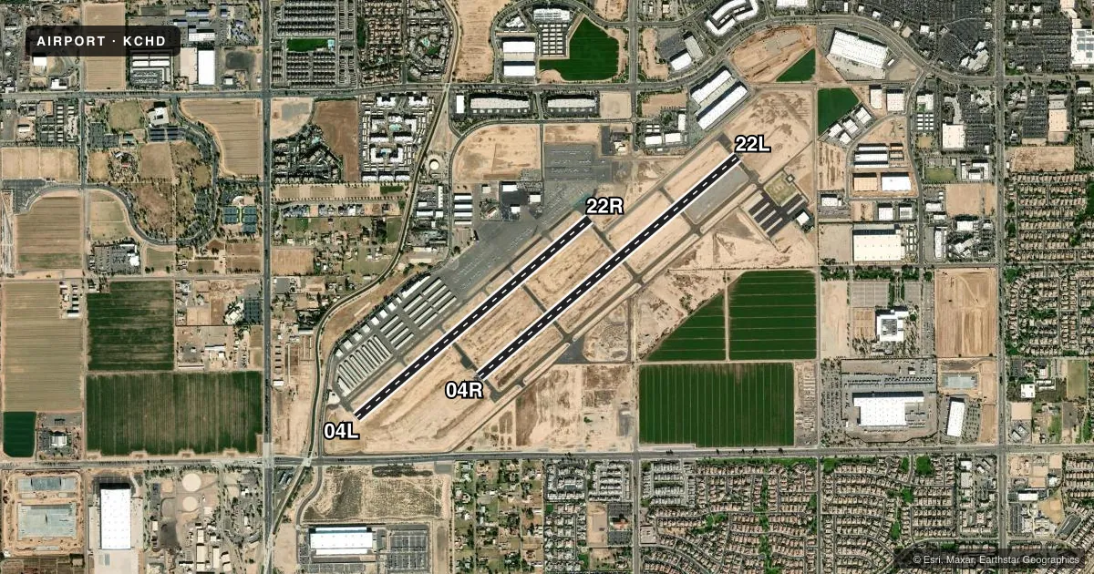
Runways & pattern
Full pagePattern entry · RWY 04R
RIGHT TRAFFIC| Runway | Heading (°M) | Length | Surface | Traffic |
|---|---|---|---|---|
| 04R/22L | 38° / 218° | 4,870 ft | ASPH | 04R R |
| 04L/22R | 38° / 218° | 4,401 ft | ASPH | 22R R |
Runway end performance
| End | TORA | TODA | ASDA | LDA | VGSI | Approach lights | Obstruction |
|---|---|---|---|---|---|---|---|
| 04R | — | — | — | — | PAPI 4-box left(3°) | — | — |
| 22L | — | — | — | — | PAPI 4-box left(3°) | — | — |
| 04L | — | — | — | — | PAPI 4-box left(3.5°) | — | — |
| 22R | — | — | — | — | PAPI 4-box left(3°) | — | — |
Declared distances in feet. TORA = takeoff run available, TODA = takeoff distance, ASDA = accelerate-stop, LDA = landing distance.
Airport sketch
Runways drawn to scale from FAA survey coordinates, rendered over satellite imagery. Not for navigation.
Approaches & charts
Services on the field
Fuel grades, oxygen, maintenance, ramp storage and lighting — as declared to the FAA by the airport operator.
Fuel & services
- Fuel
- 100LLA+
- Oxygen (bottled)
- HIGH/LOW
- Oxygen (bulk)
- HIGH/LOW
- Airframe repair
- Major
- Power plant repair
- Major
- Other services
- AVNCS,CHTR,INSTR,RNTL,SALES
Ramp & ground
- Transient storage
- Tie-down
- Landing fee
- No fee published
- Customs
- Not available
- Lighting schedule
- SEE RMK
- Beacon schedule
- SS-SR
- Beacon
- White / Green (civil land)(WG)
- Wind indicator
- Lighted
- Segmented circle
- Yes
Fuel & FBOs
Cheapest 100LL and Jet A on the field and nearby. Always confirm with the FBO before taxi.
Airport notes
Surface conditions, obstructions, local procedures, lighting outages and other notes published with each FAA cycle.
General notes
- BIRDS & WILDLIFE ON & INVOF OF ARPT.
- AVOID OTFC OF HIGH SCHOOL; 2 NM SW.
- 135 FT LGTD PWR POLES & LINES N-S 1.5 MI W.
- 135 FT UNLGTD PWR POLES & LINES E-W 1 MI S.
- TWY A BTN TWY D & F NOT VIS FM ATCT.
- TSNT HELI PRKG & PAX PUP N SIDE BY TWY N.
- HOPS ON TWY C; CHARLIE PAT FOR HEL TRNG.
- WHEN ATCT CLSD, FOR CD CTC PHOENIX APCH - 602-306-2565.
- GA TSNT FIXED WING PRKG BOXES IN FRONT OF TRML.
- PARL RWYS; STAGGERED APCH ENDS.
Lighting notes
- WHEN ATCT CLSD ACTVT PAPI RWY 04L, 04R, 22L & 22R; MIRL RWY 04R/22L & 04L/22R - CTAF. REIL RWY 4R & 22L ON CONSLY.
Runway surface & condition
- 04L/22RRWY 4L CALM WIND RWY.
- 04R/22LRWY 4R CALM WIND RWY.
Approach & departure obstructions
- 22LSHORT APCH NA.
- 22R85 FT ANT 1/4 MI N OF THR.
Other notes
- THIS AIRPORT HAS BEEN SURVEYED BY THE NATIONAL GEODETIC SURVEY.
- FIXED WING - 2300 FT MSL. ROTORWING - 1900 FT MSL.
VFR map & nearby airports
VFR sectional. Tap any ICAO chip to open that airport.
Key facts · KCHD
Answer card- ICAO
- KCHD
- Name
- CHANDLER MUNI
- Location
- CHANDLER, ARIZONA
- Elevation
- 1,243.4 ft MSL
- Traffic pattern altitude
- 2,300.4 ft MSL (1,057 AGL)
- Control tower
- Towered · 0600-2100
- Total runways
- 2
- Longest runway
- 04R/22L · 4,870 ft
- Published ILS approaches
- 0
- Published frequencies
- 10
- Magnetic variation
- 12°
- Current flight rules
- VFR
- Current wind
- 000° at 0 kt
- Favored runway now
- –
Chandler Muni sits in Chandler, Arizona. The field elevation is 1,243.4 ft MSL. It has two asphalt runways. The longest is 4,870 ft on 04R/22L. The airport is towered from 0600 to 2100. No ILS approaches are published here.
Pattern altitude is 2,300.4 ft MSL for fixed wing. That is 1,057 ft AGL. Rotorwing pattern altitude is 1,900 ft MSL. Chandler Air Service is on the field. It carries 100LL, Jet A and Jet A Prist. Call them at (480) 963-6420 for current service details.
A few local items matter here. Runway 4L is the calm wind runway. The parallel runways have staggered approach ends. There are 135 ft lighted power poles and lines 1.5 miles west of the field. An 85 ft antenna sits one quarter mile north of the 22R threshold. Birds and wildlife are reported on and near the airport. When the tower is closed, use the PAPI for 04L, 04R, 22L and 22R. Medium intensity runway lights are available on both runways and are controlled by CTAF. For clearance delivery when the tower is closed, contact Phoenix Approach. Avoid overflight of the high school 2 NM southwest.