METAR & TAF P08
Current METAR
Observed 02:15Z
KP08 270215Z AUTO 28006KT 10SM CLR 40/14 A2985 RMK AO2
- Wind
- 280° @ 6 kt
- Visibility
- 10 SM
- Temp / Dew
- 40°C / 14°C
- Altimeter
- 29.85 inHg
- Clouds
- CLR
- Density alt
- 5,041 ft
- Ceiling
- Unlimited
- Rules
- VFR
Airport info & contacts
Manager on record, flight service, ARTCC, attendance schedule and pattern altitude — published by the FAA and refreshed every 28 days.
Location
- From city
- 5 NM SE
- VFR sectional
- PHOENIX
- ARTCC
- ZAB · ALBUQUERQUE
- NOTAM facility
- PRC (NOTAM-D)
Airport manager
- Name
- JAMES MYERS
- Phone
- 520-723-6075
- Address
- CITY OF COOLIDGE MUNI ARPT, 131 WEST PINKLEY, COOLIDGE AZ 85128
Flight service · Hours
- FSS PRC
- PRESCOTT1-800-WX-BRIEF
- Attendance
- MON-FRI · 0800-1700
Frequencies
Tap any row to copy the frequency to your clipboard.
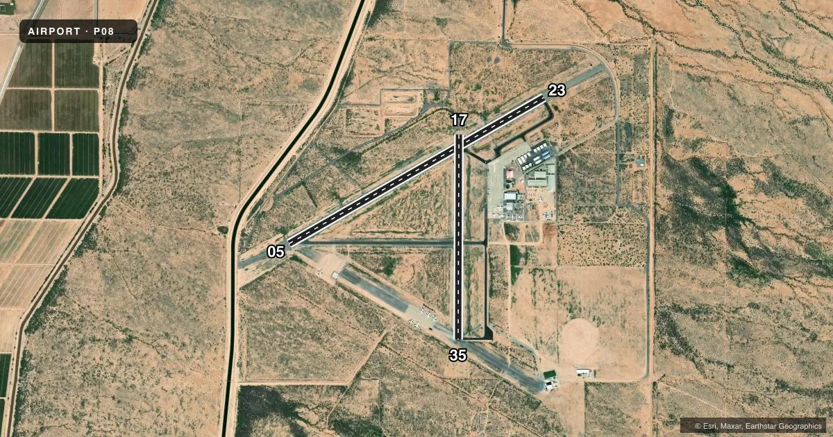
Runways & pattern
Full pagePattern entry · RWY 23
RIGHT TRAFFIC| Runway | Heading (°M) | Length | Surface | Traffic |
|---|---|---|---|---|
| 05/23Favored | 48° / 228° | 5,564 ft | ASPH | 23 R |
| 17/35 | 168° / 348° | 3,872 ft | ASPH | 17 R |
Runway end performance
| End | TORA | TODA | ASDA | LDA | VGSI | Approach lights | Obstruction |
|---|---|---|---|---|---|---|---|
| 05 | — | — | — | — | PAPI 2-box left(3°) | — | — |
| 23 | — | — | — | — | PAPI 2-box left(3°) | — | — |
| 17 | — | — | — | — | — | — | 12', brush, 327' from thr, 75' R of cntrln, slope 10 |
Declared distances in feet. TORA = takeoff run available, TODA = takeoff distance, ASDA = accelerate-stop, LDA = landing distance.
Airport sketch
Runways drawn to scale from FAA survey coordinates, rendered over satellite imagery. Not for navigation.
Approaches & charts
Services on the field
Fuel grades, oxygen, maintenance, ramp storage and lighting — as declared to the FAA by the airport operator.
Fuel & services
- Fuel
- 100LLA
Ramp & ground
- Transient storage
- Tie-down
- Landing fee
- No fee published
- Customs
- Not available
- Lighting schedule
- SEE RMK
- Beacon schedule
- SS-SR
- Beacon
- White / Green (civil land)(WG)
- Wind indicator
- Yes
- Segmented circle
- Yes
Fuel & FBOs
Cheapest 100LL and Jet A on the field and nearby. Always confirm with the FBO before taxi.
Airport notes
Surface conditions, obstructions, local procedures, lighting outages and other notes published with each FAA cycle.
General notes
- PAJA TRNG ON ARPT; DROP ZONE ESE RWY 35. AEROBATIC ACT SFC-4500 FT 0.5 NM E.
- LIVESTOCK & LRG MIL ACFT ON & INVOF ARPT.
- R2310 OPS - AZARNG 138.15
- FOR CD CTC ALBUQUERQUE ARTCC AT 505-856-4861.
Lighting notes
- DUSK-DAWN: ACTVT MIRL RWY 05/23 & 17/35 - CTAF. PAPI RWY 05 & 23; REIL 05 & 23 OPR CONSLY.
Fuel notes
- 100LLSELF SVC WITH CREDIT CARD
Runway surface & condition
- 05/2325 FT PAVED SHOULDERS EACH SIDE.
Approach & departure obstructions
- 17CTLG OBSTN EXCEEDS 45 DEG SLOPE.
VFR map & nearby airports
VFR sectional. Tap any ICAO chip to open that airport.
Key facts · P08
Answer card- ICAO
- P08
- Name
- COOLIDGE MUNI
- Location
- COOLIDGE, ARIZONA
- Elevation
- 1,576.1 ft MSL
- Traffic pattern altitude
- 2,576.1 ft MSL (1,000 AGL)
- Control tower
- Non-towered (use CTAF)
- Total runways
- 2
- Longest runway
- 05/23 · 5,564 ft
- Published ILS approaches
- 0
- Published frequencies
- 2
- Magnetic variation
- 12°
- Current flight rules
- VFR
- Current wind
- 280° at 6 kt
- Favored runway now
- RWY 23
Coolidge Muni is in Coolidge, Arizona. The field elevation is 1,576.1 ft MSL. It has two asphalt runways. The longest is runway 05/23 at 5,564 ft. There is no control tower. CTAF and UNICOM are both 123.075.
No ILS approaches are published here. Pattern altitude is not published, so a light piston pilot should plan on the standard 1,000 ft AGL pattern unless the current Chart Supplement says otherwise. SkyFlight Services is on the field. It carries 100LL and Jet A. Self-serve 100LL is available with credit card. Runway 05/23 has 25 ft paved shoulders on each side. Medium intensity runway lights are activated from dusk to dawn by CTAF on both runways. PAPI is available on runway 05 and runway 23. REILs operate continuously on runway 05 and runway 23.
This is a field to brief carefully. Livestock and large military aircraft are reported in the area. Parachute jump training occurs here. The drop zone is east-southeast of runway 35. Aerobatic activity occurs from the surface to 4,500 ft within 0.5 NM east. There is also a cataloged obstruction near runway 17 that exceeds a 45 degree slope. For clearance delivery, contact Albuquerque ARTCC. Check the current FAA Chart Supplement for any noise or curfew restrictions before flying in.