METAR & TAF KMZJ
Current METAR
Observed 05:55Z
KMZJ 270555Z AUTO 28004KT 10SM CLR 35/15 A2992 RMK AO2
- Wind
- 280° @ 4 kt
- Visibility
- 10 SM
- Temp / Dew
- 35°C / 15°C
- Altimeter
- 29.92 inHg
- Clouds
- CLR
- Density alt
- 4,747 ft
- Ceiling
- Unlimited
- Rules
- VFR
Airport info & contacts
Manager on record, flight service, ARTCC, attendance schedule and pattern altitude — published by the FAA and refreshed every 28 days.
Location
- From city
- 7 NM NW
- VFR sectional
- PHOENIX
- ARTCC
- ZAB · ALBUQUERQUE
- NOTAM facility
- MZJ (NOTAM-D)
Airport manager
- Name
- JIM PETTY
- Phone
- 520-866-6545
- Address
- P.O. BOX 749, BOX #91, FLORENCE AZ 85132
Flight service · Hours
- FSS PRC
- PRESCOTT1-800-WX-BRIEF
- Attendance
- 0700-1530
Frequencies
Tap any row to copy the frequency to your clipboard.
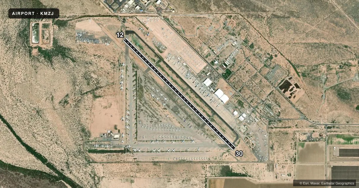
Runways & pattern
Full pagePattern entry · RWY 30
RIGHT TRAFFICAirport sketch
Runways drawn to scale from FAA survey coordinates, rendered over satellite imagery. Not for navigation.
Approaches & charts
Services on the field
Fuel grades, oxygen, maintenance, ramp storage and lighting — as declared to the FAA by the airport operator.
Fuel & services
- Fuel
- 100LLA
- Oxygen (bulk)
- HIGH/LOW
- Airframe repair
- Major
- Power plant repair
- Major
Ramp & ground
- Transient storage
- Tie-down
- Landing fee
- No fee published
- Customs
- Not available
- Beacon schedule
- SS-SR
- Beacon
- White / Green (civil land)(WG)
- Wind indicator
- Lighted
- Segmented circle
- Yes
Fuel & FBOs
Cheapest 100LL and Jet A on the field and nearby. Always confirm with the FBO before taxi.
Airport notes
Surface conditions, obstructions, local procedures, lighting outages and other notes published with each FAA cycle.
General notes
- NMRS CTLD VEHICLES XNG RWY 12/30.
- MIL PJE ALL ALTS & HRS. MIL HEL T 0700-2300; EXCEPT HOL.
- SI CTC UNICOM 5 MI OUT.
- STORAGE/OVNGT FEE - 520-682-4181 EXT 5755.
- MIL: NG COMPLEX TSNT PPR - SILVER BELL D853-5931/C520-750-5931.
- TWY C CLSD INDEFLY.
- WILDLIFE ON OR INVOF ARPT.
- FOR CD CTC TUCSON APCH AT 520-829-6121.
- FUEL & GND SUPPORT SVC AFT HR & HOL PPR - 520-682-4181 X5755; CALL IN FEE.
Runway surface & condition
- 12/30DOUBLE/TRIPLE DUAL TANDEM WHEEL MAX 500000 LB; EXC PPR - 520 682 4181 EXT 5755.
- 12/30RWY 12 CALM WIND RWY. PAJA SW OF RWY. NMRS CTLD VEHICLES XNG RWY.
- 12/3020 FT PAVED SHOULDERS.
Approach & departure obstructions
- 1210 FT OPN CHNL 1000 FT FM RWY END.
Other notes
- THIS AIRPORT HAS BEEN SURVEYED BY THE NATIONAL GEODETIC SURVEY.
- TPA 1109 FT AGL FIXED WING; 709 FT AGL ROTARY WING.
- UNICOM MNT INTMTY DURG BUS HR.
VFR map & nearby airports
VFR sectional. Tap any ICAO chip to open that airport.
Key facts · KMZJ
Answer card- ICAO
- KMZJ
- Name
- PINAL AIRPARK
- Location
- MARANA, ARIZONA
- Elevation
- 1,893.1 ft MSL
- Traffic pattern altitude
- 2,893.1 ft MSL (1,000 AGL)
- Control tower
- Non-towered (use CTAF)
- Total runways
- 1
- Longest runway
- 12/30 · 6,849 ft
- Published ILS approaches
- 0
- Published frequencies
- 2
- Magnetic variation
- 12°
- Current flight rules
- VFR
- Current wind
- 280° at 4 kt
- Favored runway now
- RWY 30
Pinal Airpark is in Marana, Arizona. Field elevation is 1,893.1 ft MSL. The airport has one runway, 12/30, which is 6,849 ft long with asphalt pavement and 20 ft paved shoulders. There is no control tower. CTAF and UNICOM are both 123.05. UNICOM is monitored intermittently during business hours.
No ILS approaches are published here. The published fixed-wing pattern altitude is 1,109 ft AGL. That puts the pattern at 3,002.1 ft MSL based on the field elevation. The runway is marked as the calm wind runway on 12. Taxiway C is closed indefinitely. Wildlife is reported on or near the airport. Numerous controlled vehicles also cross runway 12/30, so keep your head on a swivel in the pattern and on the taxi.
Ascent Aviation Services is on the field. It carries 100LL, Jet A and Jet A Prist. For clearance delivery, contact Tucson Approach. If you need after-hours fuel or ground support, call ahead for prior permission. A call-in fee applies. Pilots should also check the current FAA Chart Supplement for any updated operating notes before arrival.