METAR & TAF E60
E60 does not publish a METAR.
Showing the nearest reporting station: KCGZ (CASA GRANDE MUNI) · 12.7 NM away. Conditions at E60 may differ.
METAR · KCGZ
Observed 10:56Z
KCGZ 211056Z AUTO 11005KT 10SM BKN075 BKN100 27/22 RMK AO2 LTG DSNT S SLPNO T02670217 PNO $
- Wind
- 110° @ 5 kt
- Visibility
- 10 SM
- Temp / Dew
- 27°C / 22°C
- Altimeter
- —
- Clouds
- BKN
- Density alt
- 3,314 ft
- Ceiling
- 7,500 ft AGL
- Rules
- VFR
Airport info & contacts
Manager on record, flight service, ARTCC, attendance schedule and pattern altitude — published by the FAA and refreshed every 28 days.
Location
- From city
- 3 NM NW
- VFR sectional
- PHOENIX
- Pattern altitude
- 800 ft AGL · 2,311 ft MSL
- ARTCC
- ZAB · ALBUQUERQUE
- NOTAM facility
- PRC (NOTAM-D)
Airport manager
- Name
- KRISTINA WASINIAK
- Phone
- 520-466-9201
- Address
- C/O CITY OF ELOY, 595 NORTH C ST, ELOY AZ 85131
Flight service · Hours
- FSS PRC
- PRESCOTT1-800-WX-BRIEF
- Attendance
- 0700-1600
Frequencies
Tap any row to copy the frequency to your clipboard.
Runways & pattern
Full pagePattern entry · RWY 02
LEFT TRAFFICRunway end performance
| End | TORA | TODA | ASDA | LDA | VGSI | Approach lights | Obstruction |
|---|---|---|---|---|---|---|---|
| 02 | — | — | — | — | PAPI 2-box left(3°) | — | — |
| 20 | — | — | — | — | PAPI 2-box left(3°) | — | — |
Declared distances in feet. TORA = takeoff run available, TODA = takeoff distance, ASDA = accelerate-stop, LDA = landing distance.
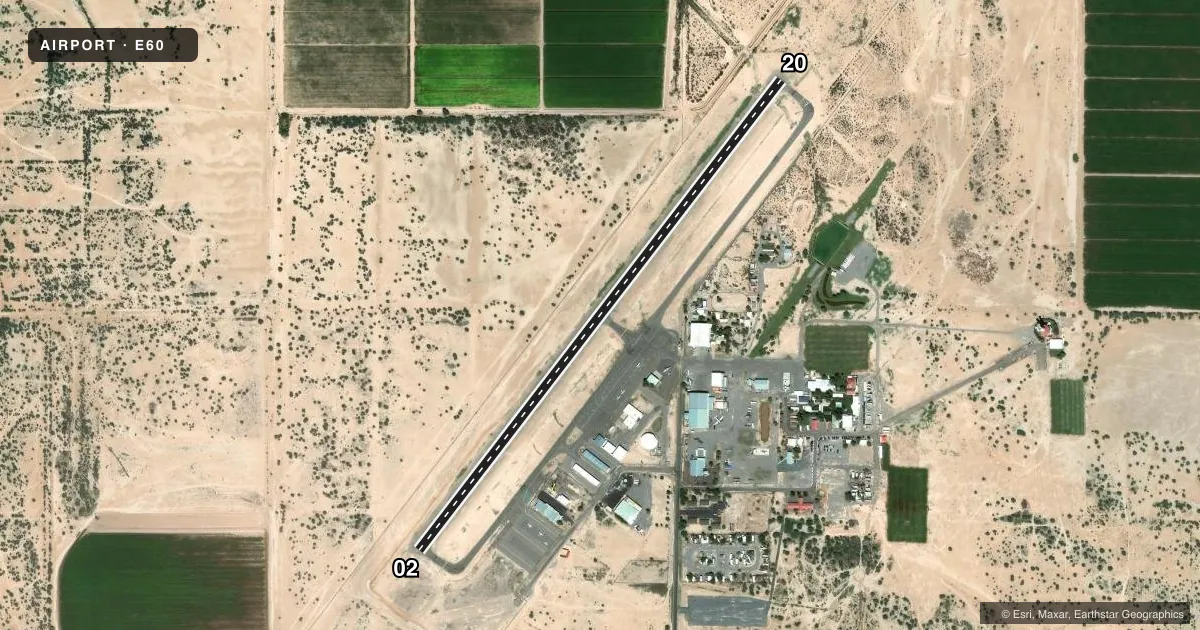
Airport sketch
Runways drawn to scale from FAA survey coordinates, rendered over satellite imagery. Not for navigation.
Approaches & charts
Services on the field
Fuel grades, oxygen, maintenance, ramp storage and lighting — as declared to the FAA by the airport operator.
Fuel & services
- Fuel
- 100LLA
- Airframe repair
- Minor
- Power plant repair
- Minor
- Other services
- AGRI,AMB,PAJA
Ramp & ground
- Transient storage
- Tie-down
- Hangar
- Landing fee
- No fee published
- Customs
- Not available
- Lighting schedule
- SEE RMK
- Beacon schedule
- SS-SR
- Beacon
- White / Green (civil land)(WG)
- Wind indicator
- Lighted
- Segmented circle
- Yes
Fuel & FBOs
Cheapest 100LL and Jet A on the field and nearby. Always confirm with the FBO before taxi.
Airport notes
Surface conditions, obstructions, local procedures, lighting outages and other notes published with each FAA cycle.
General notes
- CTN: SEASONAL CROP DUST OPS.
- APCH FM W; OVR FLT OF ARPT NA. HVY PAJA SR-SS E SIDE.
- FOR CD CTC ALBUQUERQUE ARTCC AT 505-856-4861.
Lighting notes
- ACTVT MIRL RWY 02/20 - CTAF; REIL RWY 02 & 20; PAPI RWY 02 & 20 - OPR CONSLY.
Fuel notes
- 100LLSELF SVC H24 WITH CREDIT CARD.
Runway surface & condition
- 02/20WIND 10 KT OR LESS; ARR RWY 20 & DEP RWY 02.
Approach & departure obstructions
- 021-2 FT BRUSH 0-200 FT FM RWY END ACRS THR.
- 203 FT BRUSH 0-200 FT FM THR 75-250 FT L OF CNTRLN; 4 FT BRUSH 100-200 FM THR 75-250 FT R OF CNTRLN.
Other notes
- AVBL - 520-466-3733.
- MANAGERFRANK FRASSETTO - 520-466-3753.
VFR map & nearby airports
VFR sectional. Tap any ICAO chip to open that airport.
Key facts · E60
Answer card- ICAO
- E60
- Name
- ELOY MUNI
- Location
- ELOY, ARIZONA
- Elevation
- 1,511.1 ft MSL
- Traffic pattern altitude
- 2,311.1 ft MSL (800 AGL)
- Control tower
- Non-towered (use CTAF)
- Total runways
- 1
- Longest runway
- 02/20 · 3,901 ft
- Published ILS approaches
- 0
- Published frequencies
- 2
- Magnetic variation
- 12°
- Current flight rules
- VFR
- Current wind
- 110° at 5 kt
- Favored runway now
- RWY 02
Eloy Muni sits in Eloy, Arizona. Field elevation is 1,511.1 ft MSL. The airport has one runway. Runway 02/20 is 3,901 ft long with asphalt pavement. The field is not towered. CTAF and UNICOM are both 122.8. No ILS approaches are published here.
Pattern altitude is 800 ft AGL. That works out to 2,311.1 ft MSL at this field. The published remarks matter here. When wind is 10 knots or less, arrivals use runway 20 and departures use runway 02. Self-serve 100LL is available 24 hours with a credit card. Bel America is on the field and carries 100LL and Jet A.
This is a place to brief the runway environment before you go in. There is brush near the runway 20 threshold. There is also brush near the threshold of runway 02. Approach from the west. Overflight of the airport is not authorized. Seasonal crop dusting operations are also a factor, so keep a sharp scan in the pattern and on arrival. Medium intensity runway lights are CTAF-activated. Runway end identifier lights are installed on both ends. PAPI is published on runway 02 and runway 20. If you need clearance delivery, contact Albuquerque ARTCC.