METAR & TAF KIWA
Current METAR
Observed 08:35Z
KIWA 270835Z AUTO 27007KT 10SM CLR 36/16 A2987 RMK AO2 T03580157
- Wind
- 270° @ 7 kt
- Visibility
- 10 SM
- Temp / Dew
- 36°C / 16°C
- Altimeter
- 29.87 inHg
- Clouds
- CLR
- Density alt
- 4,298 ft
- Ceiling
- Unlimited
- Rules
- VFR
Airport info & contacts
Manager on record, flight service, ARTCC, attendance schedule and pattern altitude — published by the FAA and refreshed every 28 days.
Location
- From city
- 20 NM SE
- VFR sectional
- PHOENIX
- Pattern altitude
- 1,218 ft AGL · 2,602 ft MSL
- ARTCC
- ZAB · ALBUQUERQUE
- NOTAM facility
- IWA (NOTAM-D)
Airport manager
- Name
- IVAN SMITH
- Phone
- 480-988-7708
- Address
- 5835 S. SOSSAMAN ROAD, MESA AZ 85212-0919
Flight service · Hours
- FSS PRC
- PRESCOTT1-800-WX-BRIEF
- Attendance
- ALL
Frequencies
Tap any row to copy the frequency to your clipboard.
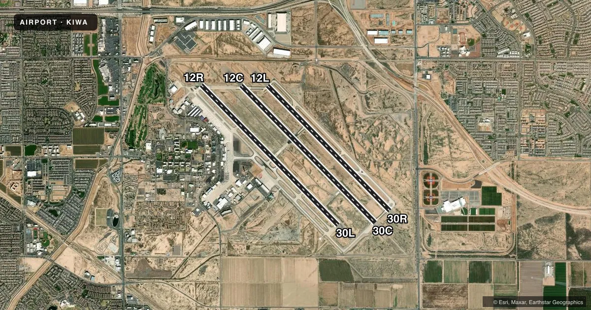
Runways & pattern
Full pagePattern entry · RWY 30L
LEFT TRAFFIC| Runway | Heading (°M) | Length | Surface | Traffic |
|---|---|---|---|---|
| 12R/30LFavored | 123° / 303° | 10,401 ft | CONC | 12R R |
| 12C/30C | 123° / 303° | 10,201 ft | ASPH-CONC | Standard L |
| 12L/30R | 123° / 303° | 9,300 ft | CONC | 30R R |
Runway end performance
| End | TORA | TODA | ASDA | LDA | VGSI | Approach lights | Obstruction |
|---|---|---|---|---|---|---|---|
| 12R | 10,401' | 10,401' | 10,401' | 10,401' | PAPI 4-box left(3°) | — | — |
| 30L | 10,401' | 10,401' | 10,401' | 10,401' | PAPI 4-box left(3°) | — | — |
| 12C | 10,201' | 10,201' | 10,201' | 10,201' | PAPI 4-box left(3°) | — | — |
| 30C | 10,201' | 10,201' | 10,201' | 10,201' | PAPI 4-box left(3°) | — | — |
| 12L | 9,300' | 9,300' | 9,300' | 9,300' | PAPI 4-box left(3°) | — | — |
| 30R | 9,300' | 9,300' | 9,300' | 9,300' | PAPI 4-box left(3°) | — | — |
Declared distances in feet. TORA = takeoff run available, TODA = takeoff distance, ASDA = accelerate-stop, LDA = landing distance.
Airport sketch
Runways drawn to scale from FAA survey coordinates, rendered over satellite imagery. Not for navigation.
Approaches & charts
ILS · 1
Services on the field
Fuel grades, oxygen, maintenance, ramp storage and lighting — as declared to the FAA by the airport operator.
Fuel & services
- Fuel
- 100LLA
- Oxygen (bottled)
- HIGH/LOW
- Airframe repair
- Minor
- Power plant repair
- Major
- Other services
- AMB,AVNCS,CARGO,CHTR,INSTR,RNTL
Ramp & ground
- Transient storage
- Tie-down
- Hangar
- Landing fee
- Yes
- Customs
- Not available
- Lighting schedule
- SEE RMK
- Beacon schedule
- SS-SR
- Beacon
- White / Green (civil land)(WG)
- Wind indicator
- Yes
- Segmented circle
- Yes
Fuel & FBOs
Cheapest 100LL and Jet A on the field and nearby. Always confirm with the FBO before taxi.
Airport notes
Surface conditions, obstructions, local procedures, lighting outages and other notes published with each FAA cycle.
General notes
- WILDLIFE INVOF ARPT.
- NOISE ABATEMENT PROC IN EFCT; AVOID LOW OVR FLT OF NOISE SENSITIVE AREAS SRNDG ARPT.
- TWY Y RSTD TO WINGSPAN LESS THAN 79 FT.
- 7 FT FENCE S PORTION OF TWY W APRON.
- LRG/HVY INBOARD ENGINE TAX ONLY.
- NON EMERG AV-8 MODEL OPS LMTD TO RWY 12L/30R.
- 24 HR PPR FOR UNSKED ACR GTR THAN 30 PAX SEATS - ARPT OPS.
- FOR CD WHEN ATCT CLSD, CTC PHOENIX APCH AT 602-306-2565.
- FUEL AVBL H24 - 480-988-7700 OR 129.875.
Lighting notes
- WHEN ATCT CLSD LGTS ON CONSLY.
Runway surface & condition
- 12C/30CPCR VALUE: 692/R/D/W/T
- 12L/30RPCR VALUE: 858/R/C/W/T
- 12R/30LPCR VALUE: 605/R/C/W/T
Approach & departure obstructions
- 30RSPORT FIELD LGTG E OF APCH.
Other notes
- US GOV OWNED, NON REVENUE & FLT TRNG UP TO 12500 LB LNDG FEE NA.
- TPA FIXED WING 1218 FT AGL, JET 1718 FT AGL, ROTORCRAFT 718 FT AGL.
VFR map & nearby airports
VFR sectional. Tap any ICAO chip to open that airport.
Key facts · KIWA
Answer card- ICAO
- KIWA
- Name
- MESA GATEWAY
- Location
- PHOENIX, ARIZONA
- Elevation
- 1,384.1 ft MSL
- Traffic pattern altitude
- 2,602.1 ft MSL (1,218 AGL)
- Control tower
- Towered · 0500-2400
- Total runways
- 3
- Longest runway
- 12R/30L · 10,401 ft
- Published ILS approaches
- 1
- Published frequencies
- 12
- Magnetic variation
- 13°
- Current flight rules
- VFR
- Current wind
- 270° at 7 kt
- Favored runway now
- RWY 30L
Mesa Gateway Airport is in Phoenix, Arizona. The field elevation is 1,384.1 ft MSL. It has three runways. The longest is runway 12R/30L at 10,401 ft. The airport has a control tower. Tower hours are 0500 to 2400. One ILS approach is published for runway 30C.
Pattern altitude is 1,218 ft AGL. That puts the traffic pattern at 2,602.1 ft MSL. Gateway Aviation Services is on the field. It carries 100LL, Jet A and Jet A Prist. Fuel is available 24 hours a day. The published remarks also say noise abatement procedures are in effect. Avoid low overflight of noise sensitive areas around the airport.
This is a busy Phoenix-area field with three long paved runways. Runway headings are 136° and 316° magnetic. Taxiway Y is restricted to aircraft with a wingspan under 79 ft. Non-emergency AV-8 model operations are limited to runway 12L/30R. When the tower is closed, the lights stay on continuously. If you are planning a large aircraft arrival or anything outside the routine flow, check the current FAA Chart Supplement or call airport operations before you go.