METAR & TAF E77
Current METAR
Observed 17:15Z
KE77 271715Z AUTO 25008KT 230V300 10SM 35/16 A3014 RMK AO2
- Wind
- 250° @ 8 kt
- Visibility
- 10 SM
- Temp / Dew
- 35°C / 16°C
- Altimeter
- 30.14 inHg
- Clouds
- Clear
- Density alt
- 6,184 ft
- Ceiling
- Unlimited
- Rules
- VFR
Airport info & contacts
Manager on record, flight service, ARTCC, attendance schedule and pattern altitude — published by the FAA and refreshed every 28 days.
Location
- From city
- 2 NM NW
- VFR sectional
- PHOENIX
- ARTCC
- ZAB · ALBUQUERQUE
- NOTAM facility
- PRC (NOTAM-D)
Airport manager
- Name
- JIM PETTY
- Phone
- 520-866-6545
- Address
- PO BOX 749, FLORENCE AZ 85132
Flight service · Hours
- FSS PRC
- PRESCOTT1-800-WX-BRIEF
- Attendance
- Unattended
Frequencies
Tap any row to copy the frequency to your clipboard.
Runways & pattern
Full pagePattern entry · RWY 29
RIGHT TRAFFICRunway end performance
| End | TORA | TODA | ASDA | LDA | VGSI | Approach lights | Obstruction |
|---|---|---|---|---|---|---|---|
| 11 | — | — | — | — | PAPI 2-box left(3°) | — | — |
| 29 | — | — | — | — | PAPI 2-box right(3°) | — | 6', brush, 205' from thr, 115' R of cntrln, slope 0 |
Declared distances in feet. TORA = takeoff run available, TODA = takeoff distance, ASDA = accelerate-stop, LDA = landing distance.
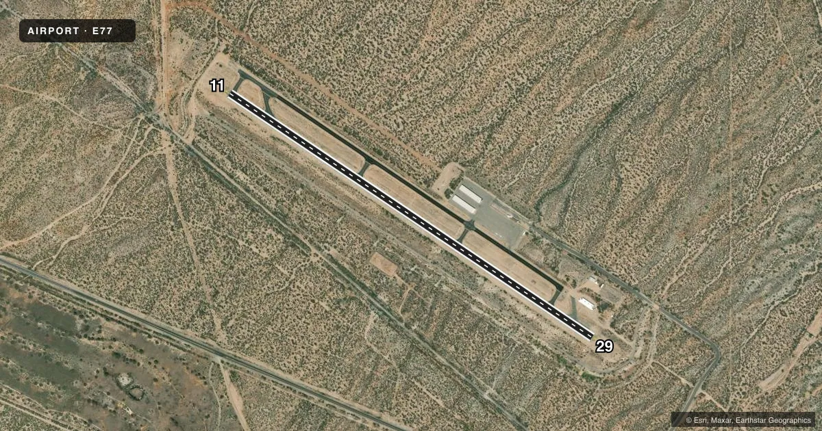
Airport sketch
Runways drawn to scale from FAA survey coordinates, rendered over satellite imagery. Not for navigation.
Approaches & charts
Services on the field
Fuel grades, oxygen, maintenance, ramp storage and lighting — as declared to the FAA by the airport operator.
Fuel & services
- Fuel
- 100LL
- Other services
- INSTR
Ramp & ground
- Transient storage
- Tie-down
- Landing fee
- No fee published
- Customs
- Not available
- Lighting schedule
- SEE RMK
- Beacon schedule
- SS-SR
- Beacon
- White / Green (civil land)(WG)
- Wind indicator
- Lighted
- Segmented circle
- Yes
Fuel & FBOs
Cheapest 100LL and Jet A on the field and nearby. Always confirm with the FBO before taxi.
Airport notes
Surface conditions, obstructions, local procedures, lighting outages and other notes published with each FAA cycle.
General notes
- RISING TRRN W; 75 FT HILL 500-1000 FT FM RWY END 350-500 FT R OF CNTRLN.
- FOR CD CTC ALBUQUERQUE ARTCC AT 505-856-4861.
Lighting notes
- ACTVT PAPI RWY 11 & 29; MIRL RWY 11/29 - CTAF.
Fuel notes
- 100LLAVBL H24 WITH CREDIT CARD; EXC AMERICAN EXPRESS.
Runway surface & condition
- 11/292-4 FT BRUSH IN PRIM SFC 45-75 FT FM CNTRLN.
Approach & departure obstructions
- 293-6 FT BRUSH 0-200 FT FM THR 90-125 FT L OF CNTRLN; 3-5 FT BRUSH 50-200 FT FM THR 90-125 FT R OF CNTRLN.
- 116 FT GULLY 300 FT FM THR.
- 296 FT DROP OFF 90 FT R OF CNTRLN 165 - 325 FT FM THR.
- 11CTL OBSTN EXCEEDS 45 DEG SLOPE.
Other notes
- ESTABD PRIOR TO 5/15/59.
- MANAGEREMERG - SHERIFF 800-420-8689.
VFR map & nearby airports
VFR sectional. Tap any ICAO chip to open that airport.
Key facts · E77
Answer card- ICAO
- E77
- Name
- SAN MANUEL
- Location
- SAN MANUEL, ARIZONA
- Elevation
- 3,271.8 ft MSL
- Traffic pattern altitude
- 4,271.8 ft MSL (1,000 AGL)
- Control tower
- Non-towered (use CTAF)
- Total runways
- 1
- Longest runway
- 11/29 · 4,207 ft
- Published ILS approaches
- 0
- Published frequencies
- 1
- Magnetic variation
- 12°
- Current flight rules
- VFR
- Current wind
- 250° at 8 kt
- Favored runway now
- RWY 29
San Manuel Airport sits in San Manuel, Arizona. The field elevation is 3,271.8 ft MSL. It has one runway. Runway 11/29 is 4,207 ft long with an asphalt surface. There is no control tower. CTAF is 122.9. No ILS approaches are published here.
Pattern altitude is not published. Use 1,000 ft AGL as the standard light-piston pattern unless local conditions or published guidance say otherwise. That puts the pattern at about 4,271.8 ft MSL. San Manuel Airport is a good place to pay attention to terrain and runway environment. Rising terrain is west of the field. There is also a 75-foot hill near the runway end on the west side. Brush is reported in the primary surface near runway 11/29. Runway 29 also has brush near the threshold plus a drop-off off to the right. Runway 11 has a gully near the threshold.
San Manuel Airport on the field carries 100LL. It is available 24 hours with credit card, except American Express. PAPI lighting is available on runways 11 and 29. Medium intensity runway lights are on runway 11/29 and are controlled by CTAF. For clearance delivery, contact Albuquerque ARTCC. For emergencies, the published contact is the sheriff. Check the current FAA Chart Supplement before flight for any updated operational notes.