METAR & TAF E67
E67 does not publish a METAR.
Showing the nearest reporting station: KMZJ (PINAL AIRPARK) · 38.5 NM away. Conditions at E67 may differ.
METAR · KMZJ
Observed 01:15Z
KMZJ 270115Z AUTO 32006KT 10SM CLR 40/14 A2987 RMK AO2
- Wind
- 320° @ 6 kt
- Visibility
- 10 SM
- Temp / Dew
- 40°C / 14°C
- Altimeter
- 29.87 inHg
- Clouds
- CLR
- Density alt
- 5,335 ft
- Ceiling
- Unlimited
- Rules
- VFR
Airport info & contacts
Manager on record, flight service, ARTCC, attendance schedule and pattern altitude — published by the FAA and refreshed every 28 days.
Location
- From city
- 1 NM S
- VFR sectional
- PHOENIX
- ARTCC
- ZAB · ALBUQUERQUE
- NOTAM facility
- PRC (NOTAM-D)
Airport manager
- Name
- AMANDA KENNEY
- Phone
- 520-363-5547
- Address
- 374 ALDEN ROAD, KEARNY AZ 85137
Flight service · Hours
- FSS PRC
- PRESCOTT1-800-WX-BRIEF
- Attendance
- MON-FRI · 0900-1700
Frequencies
Tap any row to copy the frequency to your clipboard.
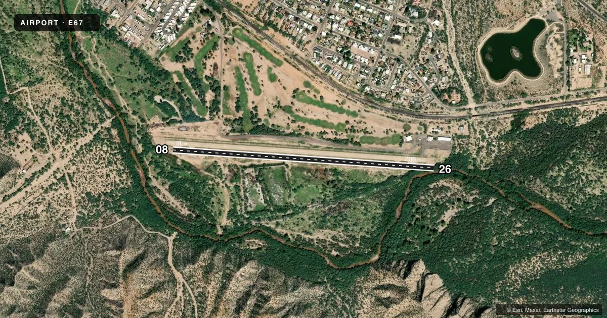
Runways & pattern
Full pagePattern entry · RWY 26
LEFT TRAFFICRunway end performance
| End | TORA | TODA | ASDA | LDA | VGSI | Approach lights | Obstruction |
|---|---|---|---|---|---|---|---|
| 08 | — | — | — | — | — | — | 14', tree, 240' from thr, 35' R of cntrln, slope 2 |
| 26 | — | — | — | — | — | — | 20', tree, 215' from thr, 0' R of cntrln, slope 0 |
Declared distances in feet. TORA = takeoff run available, TODA = takeoff distance, ASDA = accelerate-stop, LDA = landing distance.
Airport sketch
Runways drawn to scale from FAA survey coordinates, rendered over satellite imagery. Not for navigation.
Approaches & charts
Services on the field
Fuel grades, oxygen, maintenance, ramp storage and lighting — as declared to the FAA by the airport operator.
Fuel & services
- Fuel
- Not available
- Airframe repair
- Major
- Power plant repair
- Major
Ramp & ground
- Transient storage
- Tie-down
- Landing fee
- No fee published
- Wind indicator
- Yes
Fuel & FBOs
Cheapest 100LL and Jet A on the field and nearby. Always confirm with the FBO before taxi.
Airport notes
Surface conditions, obstructions, local procedures, lighting outages and other notes published with each FAA cycle.
General notes
- BIRDS, WILDFLIFE & MIL OPS INVOF ARPT.
- RAPIDLY RISING TRRN ALL QUADS EXC SE.
- LGT NA; NIGHT OPS NOT RCMDD.
- NOISE ABATEMENT; AVOID SCHOOLS & HOMES.
- ARPT COND - 928-242-3417.
- FOR CD CTC ALBUQUERQUE ARTCC AT 505-856-4861.
Runway surface & condition
- 08/26RWY 08 CALM WIND RWY.
Approach & departure obstructions
- 08+15 FT BRUSH 100-200 FT FM THR 60-125 FT R OF CNTRLN.
- 2610-20 FT BRUSH & TREES 0-150 FT FM RWY END 90-125 FT L OF CNTRLN; 10-20 FT BRUSH & TREES 150-200 FT FM RWY END 35-125 FT L OF CNTRLN.
- 08FENCE 240 FT L & R OF RWY END. 6 FT DITCH BOTH SIDES OF RWY END 60 FT FM CNTRLN.
- 26APCH & DEP EXP TURB WHEN WIND FM NORTH. FENCE 270 FT L & R OF RWY END.
- 08APCH RATIO 31:1 TO DTHR; 14 FT TREE 435 FT FM DTHR 35 FT R OF CNTRLN.
- 26APCH RATIO 3:1 TO DTHR; 20 FT TREE 60 FT FM DTHR 100 FT L OF CNTRLN.
Other notes
- VFR CONDITIONS ONLY.
- 1EXC HOL.
VFR map & nearby airports
VFR sectional. Tap any ICAO chip to open that airport.
Key facts · E67
Answer card- ICAO
- E67
- Name
- KEARNY
- Location
- KEARNY, ARIZONA
- Elevation
- 1,833 ft MSL
- Traffic pattern altitude
- 2,833 ft MSL (1,000 AGL)
- Control tower
- Non-towered (use CTAF)
- Total runways
- 1
- Longest runway
- 08/26 · 3,400 ft
- Published ILS approaches
- 0
- Published frequencies
- 2
- Magnetic variation
- 12°
- Current flight rules
- VFR
- Current wind
- 320° at 6 kt
- Favored runway now
- RWY 26
Kearny Airport is in Kearny, Arizona. The field elevation is 1,833 ft MSL. It has one runway, 08/26, which is 3,400 ft long. There is no control tower. CTAF and UNICOM are both 122.95. No ILS approaches are published.
The pattern altitude is not published, so use the standard 1,000 ft AGL for light piston aircraft unless the current FAA Chart Supplement says otherwise. This is a VFR-only field. Lighting is not available, so night operations are not recommended. Runway 08 is listed as the calm wind runway. The airport also has terrain close in all quadrants except southeast. That matters here. Expect a tighter feel than a flat desert strip.
There are no on-field FBOs listed. Plan to verify services with the airport operator or call the field directly before arrival. Published remarks also call out birds, wildlife and military operations in the area. Runway 08 has obstacle notes near the displaced threshold. Runway 26 also has trees, brush and fence notes near the runway end. For clearance delivery, contact Albuquerque ARTCC at 505-856-4861. Check the current FAA Chart Supplement for any holiday-related notes before you go.