METAR & TAF P13
P13 does not publish a METAR.
Showing the nearest reporting station: KIWA (MESA GATEWAY) · 49.6 NM away. Conditions at P13 may differ.
METAR · KIWA
Observed 15:49Z
KIWA 271549Z 28005KT 240V360 10SM CLR 36/18 A2994
- Wind
- 280° @ 5 kt
- Visibility
- 10 SM
- Temp / Dew
- 36°C / 18°C
- Altimeter
- 29.94 inHg
- Clouds
- CLR
- Density alt
- 6,539 ft
- Ceiling
- Unlimited
- Rules
- VFR
Airport info & contacts
Manager on record, flight service, ARTCC, attendance schedule and pattern altitude — published by the FAA and refreshed every 28 days.
Location
- From city
- 7 NM SE
- VFR sectional
- PHOENIX
- ARTCC
- ZAB · ALBUQUERQUE
- NOTAM facility
- PRC (NOTAM-D)
Airport manager
- Name
- MARVIN MULL
- Phone
- 928-475-3222
- Address
- C/O SAN CARLOS APACHE TRIBE, P.O. BOX O, SAN CARLOS AZ 85550
Flight service · Hours
- FSS PRC
- PRESCOTT1-800-WX-BRIEF
- Attendance
- Unattended
Frequencies
Tap any row to copy the frequency to your clipboard.
Runways & pattern
Full pagePattern entry · RWY 27
RIGHT TRAFFICRunway end performance
| End | TORA | TODA | ASDA | LDA | VGSI | Approach lights | Obstruction |
|---|---|---|---|---|---|---|---|
| 09 | — | — | — | — | PAPI 2-box left(3°) | — | — |
| 27 | — | — | — | — | PAPI 2-box left(3°) | — | — |
Declared distances in feet. TORA = takeoff run available, TODA = takeoff distance, ASDA = accelerate-stop, LDA = landing distance.
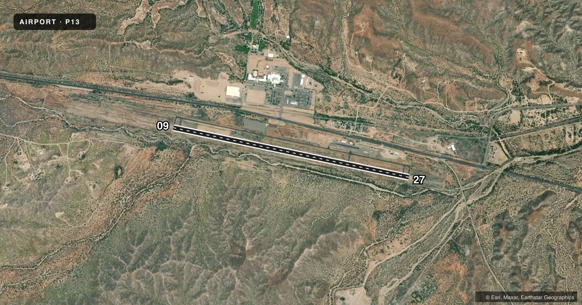
Airport sketch
Runways drawn to scale from FAA survey coordinates, rendered over satellite imagery. Not for navigation.
Approaches & charts
Services on the field
Fuel grades, oxygen, maintenance, ramp storage and lighting — as declared to the FAA by the airport operator.
Fuel & services
- Fuel
- 100LLA
Ramp & ground
- Transient storage
- Tie-down
- Landing fee
- No fee published
- Customs
- Not available
- Lighting schedule
- SEE RMK
- Beacon schedule
- SS-SR
- Beacon
- White / Green (civil land)(WG)
- Wind indicator
- Lighted
- Segmented circle
- Yes
Fuel & FBOs
Cheapest 100LL and Jet A on the field and nearby. Always confirm with the FBO before taxi.
Airport notes
Surface conditions, obstructions, local procedures, lighting outages and other notes published with each FAA cycle.
General notes
- TWO HILLS S.
- RWY HOLD & TWY EXIT SIGNS OTS INDEFLY.
- PARL TWY HAS 2-5 IN CRACKS.
Lighting notes
- ACTVT REIL RWY 09 & 27; PAPI RWY 09 & 27; MIRL RWY 09/27 - CTAF.
Runway surface & condition
- 09/27PRIM SFC 6-15 FT BRUSH 60-250 FT FM CNTRLN S OF RWY; BRUSH 75-250 FT FM CNTRLN N OF CNTRLN.
Approach & departure obstructions
- 092 FT BRUSH 50-200 FT FM THR ACRS CNTRLN.
- 27+2-7 FT BRUSH 0-200 FT FM THR ACRS CNTRLN.
Other notes
- THIS AIRPORT HAS BEEN SURVEYED BY THE NATIONAL GEODETIC SURVEY.
- RWY 27 R TFC ARMS NA.
- LGT OTS INDEF.
- MANAGER928-475-5563 & 928-812-5790.
VFR map & nearby airports
VFR sectional. Tap any ICAO chip to open that airport.
Key facts · P13
Answer card- ICAO
- P13
- Name
- SAN CARLOS APACHE
- Location
- GLOBE, ARIZONA
- Elevation
- 3,260.8 ft MSL
- Traffic pattern altitude
- 4,260.8 ft MSL (1,000 AGL)
- Control tower
- Non-towered (use CTAF)
- Total runways
- 1
- Longest runway
- 09/27 · 6,500 ft
- Published ILS approaches
- 0
- Published frequencies
- 2
- Magnetic variation
- 12°
- Current flight rules
- VFR
- Current wind
- 280° at 5 kt
- Favored runway now
- RWY 27
San Carlos Apache Airport (P13) is in Globe, Arizona. Field elevation is 3,260.8 ft MSL. The airport has one runway. Runway 09/27 is 6,500 ft asphalt and is the longest runway on the field. There is no control tower. CTAF and UNICOM are both 122.8. No ILS approaches are published.
Pattern altitude is not published. For light piston planning, use the standard 1,000 ft AGL unless the current Chart Supplement says otherwise. That puts the pattern near 4,260.8 ft MSL. Runway 27 right traffic pattern arms are not authorized. The field has published brush near both runway ends and along parts of the runway centerline area. Two hills are south of the airport. The lighted wind indicator is out of service indefinitely. Runway hold and taxiway exit signs are also out of service indefinitely.
There are no on-field FBOs listed. Check with the airport operator or call the field directly before arrival if you need fuel or ramp details. Runway end identifier lights, PAPI and medium intensity runway lights are published for both ends of 09/27. The lights are controlled by CTAF. The parallel taxiway has reported cracks, so expect a field that deserves a careful taxi and landing brief before you go in.