METAR & TAF E24
E24 does not publish a METAR.
Showing the nearest reporting station: KSOW (SHOW LOW RGNL) · 27.3 NM away. Conditions at E24 may differ.
METAR · KSOW
Observed 15:55Z
KSOW 271555Z AUTO 00000KT 10SM CLR 27/14 A3033 RMK AO2
- Wind
- 000° @ 0 kt
- Visibility
- 10 SM
- Temp / Dew
- 27°C / 14°C
- Altimeter
- 30.33 inHg
- Clouds
- CLR
- Density alt
- 7,321 ft
- Ceiling
- Unlimited
- Rules
- VFR
Airport info & contacts
Manager on record, flight service, ARTCC, attendance schedule and pattern altitude — published by the FAA and refreshed every 28 days.
Location
- From city
- 1 NM SW
- VFR sectional
- PHOENIX
- ARTCC
- ZAB · ALBUQUERQUE
- NOTAM facility
- E24 (NOTAM-D)
Airport manager
- Name
- LAREESA SANCHEZ
- Phone
- 928-338-5155
- Address
- P.O. BOX 1710, WHITERIVER AZ 85941
Flight service · Hours
- FSS PRC
- PRESCOTT1-800-WX-BRIEF
- Attendance
- APR-OCT · MON-FRI · 0700-1700
- NOV-MAR · MON-FRI · 0800-1700
Frequencies
Tap any row to copy the frequency to your clipboard.
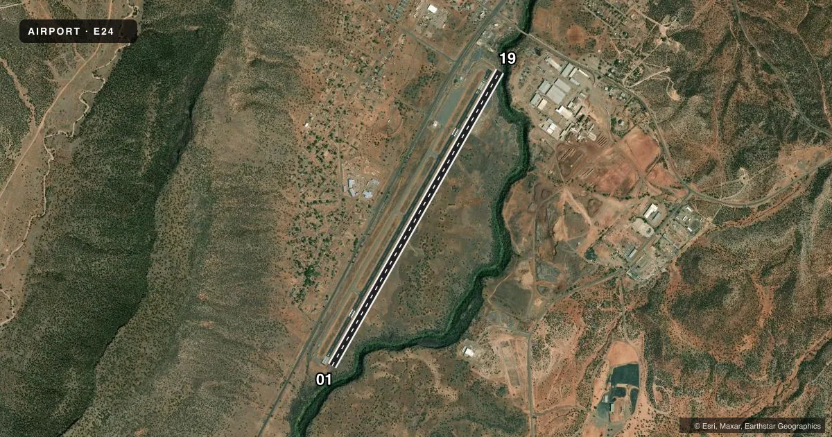
Runways & pattern
Full pagePattern entry · RWY 01
RIGHT TRAFFICRunway end performance
| End | TORA | TODA | ASDA | LDA | VGSI | Approach lights | Obstruction |
|---|---|---|---|---|---|---|---|
| 01 | 6,100' | 6,350' | 6,100' | 6,100' | PAPI 2-box left(3°) | — | — |
| 19 | 6,350' | 6,350' | 6,350' | 6,100' | — | — | 8', gnd, 201' from thr, 250' R of cntrln, slope 0 |
Declared distances in feet. TORA = takeoff run available, TODA = takeoff distance, ASDA = accelerate-stop, LDA = landing distance.
Airport sketch
Runways drawn to scale from FAA survey coordinates, rendered over satellite imagery. Not for navigation.
Approaches & charts
Services on the field
Fuel grades, oxygen, maintenance, ramp storage and lighting — as declared to the FAA by the airport operator.
Fuel & services
- Fuel
- Not available
Ramp & ground
- Transient storage
- Tie-down
- Landing fee
- No fee published
- Customs
- Not available
- Lighting schedule
- SEE RMK
- Beacon schedule
- SS-SR
- Beacon
- White / Green (civil land)(WG)
- Wind indicator
- No
- Segmented circle
- No
Fuel & FBOs
Cheapest 100LL and Jet A on the field and nearby. Always confirm with the FBO before taxi.
Airport notes
Surface conditions, obstructions, local procedures, lighting outages and other notes published with each FAA cycle.
General notes
- MTS ALL QUADS; HVY CANYON WINDS; MKD PWR LINES & WILDLIFE ON & INVOF ARPT.
- FIRE SUPPRESSION OPS MAR-OCT.
- FOR CD CTC ALBUQUERQUE ARTCC AT 505-856-4861.
- E SIDE RAMP CLSD.
Lighting notes
- ACTVT REIL RWY 01 & 19; MIRL RWY 01/19 - CTAF.
Runway surface & condition
- 01/19SVRL LGTS OTS.
Approach & departure obstructions
- 013 FT BRUSH 0-200 FT FM THR ACRS RWY END.
- 19+10 FT ROAD 0-100 FT FM THR BOTH SIDES; +10 FT BRUSH & TREES 105-150 FT FM THR 80-120 FT L OF CNTRLN; 8 FT BERM 0-200 FT FM THR 75-250 FT R OF CNTRLN.
- 01REIL OTS INDEF.
- 19REIL OTS INDEF.
- 01PAPI OTS INDEF.
- 19APCH RATIO 20:1 TO DTHR.
Other notes
- ESTABD PRIOR TO 15 MAY 1959.
VFR map & nearby airports
VFR sectional. Tap any ICAO chip to open that airport.
Key facts · E24
Answer card- ICAO
- E24
- Name
- WHITERIVER
- Location
- WHITERIVER, ARIZONA
- Elevation
- 5,153 ft MSL
- Traffic pattern altitude
- 6,153 ft MSL (1,000 AGL)
- Control tower
- Non-towered (use CTAF)
- Total runways
- 1
- Longest runway
- 01/19 · 6,350 ft
- Published ILS approaches
- 0
- Published frequencies
- 2
- Magnetic variation
- 12°
- Current flight rules
- VFR
- Current wind
- 000° at 0 kt
- Favored runway now
- –
Whiteriver Airport (E24) sits in Whiteriver, Arizona at 5,153 ft MSL. It has one runway, 01/19, which is 6,350 ft long and asphalt. The field is not towered. CTAF and UNICOM are both 122.8. No ILS approaches are published here.
Pattern altitude is not published. Use the standard 1,000 ft AGL pattern for light piston operations unless the current Chart Supplement says otherwise. That puts the normal pattern reference at 6,153 ft MSL. There are no on-field FBOs listed, so plan to verify services with the airport operator or by calling ahead before you go.
The published remarks matter here. The east side ramp is closed. Mountains are in all quadrants. Heavy canyon winds are common. Marked power lines and wildlife are also noted near the airport. Several runway lights are out of service. The PAPI is out of service indefinitely. Runway end identifier lights are also out of service indefinitely. Clearance delivery is handled through Albuquerque ARTCC at 505-856-4861. Expect a high-elevation mountain strip with terrain and wind to think about on every arrival and departure.