METAR & TAF KSOW
Current METAR
Observed 13:35Z
KSOW 271335Z AUTO 20004KT 10SM CLR 21/14 A3031 RMK AO2
- Wind
- 200° @ 4 kt
- Visibility
- 10 SM
- Temp / Dew
- 21°C / 14°C
- Altimeter
- 30.31 inHg
- Clouds
- CLR
- Density alt
- 8,192 ft
- Ceiling
- Unlimited
- Rules
- VFR
Airport info & contacts
Manager on record, flight service, ARTCC, attendance schedule and pattern altitude — published by the FAA and refreshed every 28 days.
Location
- From city
- 2 NM E
- VFR sectional
- PHOENIX
- Pattern altitude
- 800 ft AGL · 7,216 ft MSL
- ARTCC
- ZAB · ALBUQUERQUE
- NOTAM facility
- SOW (NOTAM-D)
Airport manager
- Name
- JACOB ALLEN
- Phone
- 928-532-4190
- Address
- 3150 AIRPORT LOOP, #100, SHOW LOW AZ 85901
Flight service · Hours
- FSS PRC
- PRESCOTT1-800-WX-BRIEF
- Attendance
- JAN-DEC · 0700-1900
Frequencies
Tap any row to copy the frequency to your clipboard.
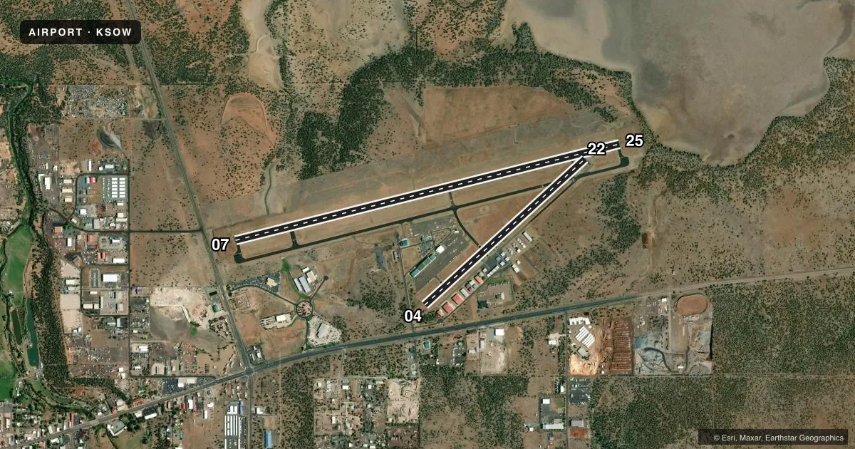
Runways & pattern
Full pagePattern entry · RWY 22
LEFT TRAFFIC| Runway | Heading (°M) | Length | Surface | Traffic |
|---|---|---|---|---|
| 07/25 | 66° / 246° | 7,202 ft | ASPH | 25 R |
| 04/22Favored | 38° / 218° | 3,938 ft | ASPH | 04 R |
Runway end performance
| End | TORA | TODA | ASDA | LDA | VGSI | Approach lights | Obstruction |
|---|---|---|---|---|---|---|---|
| 07 | 7,200' | 7,200' | 7,200' | 6,500' | PAPI 2-box left(3°) | — | — |
| 25 | 7,200' | 7,200' | 7,200' | 7,200' | PAPI 2-box left(3°) | — | — |
| 04 | 3,938' | 3,938' | 3,938' | 3,938' | — | — | — |
| 22 | 3,938' | 3,938' | 3,938' | 3,938' | — | — | — |
Declared distances in feet. TORA = takeoff run available, TODA = takeoff distance, ASDA = accelerate-stop, LDA = landing distance.
Airport sketch
Runways drawn to scale from FAA survey coordinates, rendered over satellite imagery. Not for navigation.
Approaches & charts
Services on the field
Fuel grades, oxygen, maintenance, ramp storage and lighting — as declared to the FAA by the airport operator.
Fuel & services
- Fuel
- 100LLA
- Airframe repair
- Minor
- Power plant repair
- Minor
- Other services
- CHTR,INSTR,RNTL
Ramp & ground
- Transient storage
- Tie-down
- Landing fee
- No fee published
- Customs
- Not available
- Lighting schedule
- SEE RMK
- Beacon schedule
- SS-SR
- Beacon
- White / Green (civil land)(WG)
- Wind indicator
- Lighted
- Segmented circle
- Yes
Fuel & FBOs
Cheapest 100LL and Jet A on the field and nearby. Always confirm with the FBO before taxi.
Airport notes
Surface conditions, obstructions, local procedures, lighting outages and other notes published with each FAA cycle.
General notes
- PART 77 OBSTNS & WIND SOCK IN 7-1 TRSN.
- MIL TFC INVOF ARPT.
- OVNGT TSNT & COML OPS LNDG FEE.
- RWY 04/22 & 07/25 NOT CONNECTED BY PAVEMENT AT APCH END RWY 22.
- RWY 22 & 25 SIMUL OPS NA.
- FOR CD CTC ALBUQUERQUE ARTCC AT 505-856-4861.
Lighting notes
- ACTVT REIL RWY 07 & 25; PAPI RWY 07 & 25; MIRL RWY 07/25 - CTAF.
Fuel notes
- 100LLSELF SVC FUEL H24.
Runway surface & condition
- 04/22PCR VALUE: 65/F/D/Y/T
- 07/25PCR VALUE: 269/F/D/X/T
- 04/22RWY 04/22 NOT AVBL FOR PART 121/PART 380 OPS WITH SKED PAX CARRYING OPS MORE THAN 9 PAX SEATS AND NON-SKED PAX CARRYING OPS MORE THAN 30 PAX SEATS.
Approach & departure obstructions
- 07APCH RATIO 40:1 TO DTHR.
VFR map & nearby airports
VFR sectional. Tap any ICAO chip to open that airport.
Key facts · KSOW
Answer card- ICAO
- KSOW
- Name
- SHOW LOW RGNL
- Location
- SHOW LOW, ARIZONA
- Elevation
- 6,415.5 ft MSL
- Traffic pattern altitude
- 7,215.5 ft MSL (800 AGL)
- Control tower
- Non-towered (use CTAF)
- Total runways
- 2
- Longest runway
- 07/25 · 7,202 ft
- Published ILS approaches
- 0
- Published frequencies
- 2
- Magnetic variation
- 10°
- Current flight rules
- VFR
- Current wind
- 200° at 4 kt
- Favored runway now
- RWY 22
Show Low Regional Airport sits in Show Low, Arizona. The field elevation is 6,415.5 ft MSL. It has two asphalt runways. The longest is 7,202 ft on runway 07/25. There is no control tower. CTAF and UNICOM are both 123.0.
No ILS approaches are published here. Runway 07 and runway 25 have REILs, PAPI and medium intensity runway lights that are controlled on CTAF. The pattern altitude is 800 ft AGL, which puts the traffic pattern at 7,215.5 ft MSL. That matters here because the airport is already high elevation. Expect performance planning to matter on warm days.
The on-field FBO is Show Low Regional Airport. It carries 100LL and Jet A Prist. Self-serve 100LL is available 24 hours a day. There is a landing fee for overnight transient and commercial operations, so verify the current details with the airport operator before arrival. The published remarks also note military traffic in the vicinity and Part 77 obstructions, including a wind sock in the 7-1 transition surface. Runway 22 and runway 25 simultaneous operations are not authorized. If you need clearance delivery, contact Albuquerque ARTCC at 505-856-4861.