METAR & TAF KSJN
Current METAR
Observed 14:54Z
KSJN 271454Z AUTO 27005KT 10SM CLR 27/13 A3023 RMK AO2 SLP122 T02670133 51008
- Wind
- 270° @ 5 kt
- Visibility
- 10 SM
- Temp / Dew
- 27°C / 13°C
- Altimeter
- 30.23 inHg
- Clouds
- CLR
- Density alt
- 8,169 ft
- Ceiling
- Unlimited
- Rules
- VFR
Airport info & contacts
Manager on record, flight service, ARTCC, attendance schedule and pattern altitude — published by the FAA and refreshed every 28 days.
Location
- From city
- 1 NM N
- VFR sectional
- PHOENIX
- ARTCC
- ZAB · ALBUQUERQUE
- NOTAM facility
- SJN (NOTAM-D)
Airport manager
- Name
- GARY LISTON
- Phone
- 928-337-4254
- Address
- P.O. BOX 455, ST. JOHNS AZ 85936
Flight service · Hours
- FSS PRC
- PRESCOTT1-800-WX-BRIEF
- Attendance
- 0700-1700
Frequencies
Tap any row to copy the frequency to your clipboard.
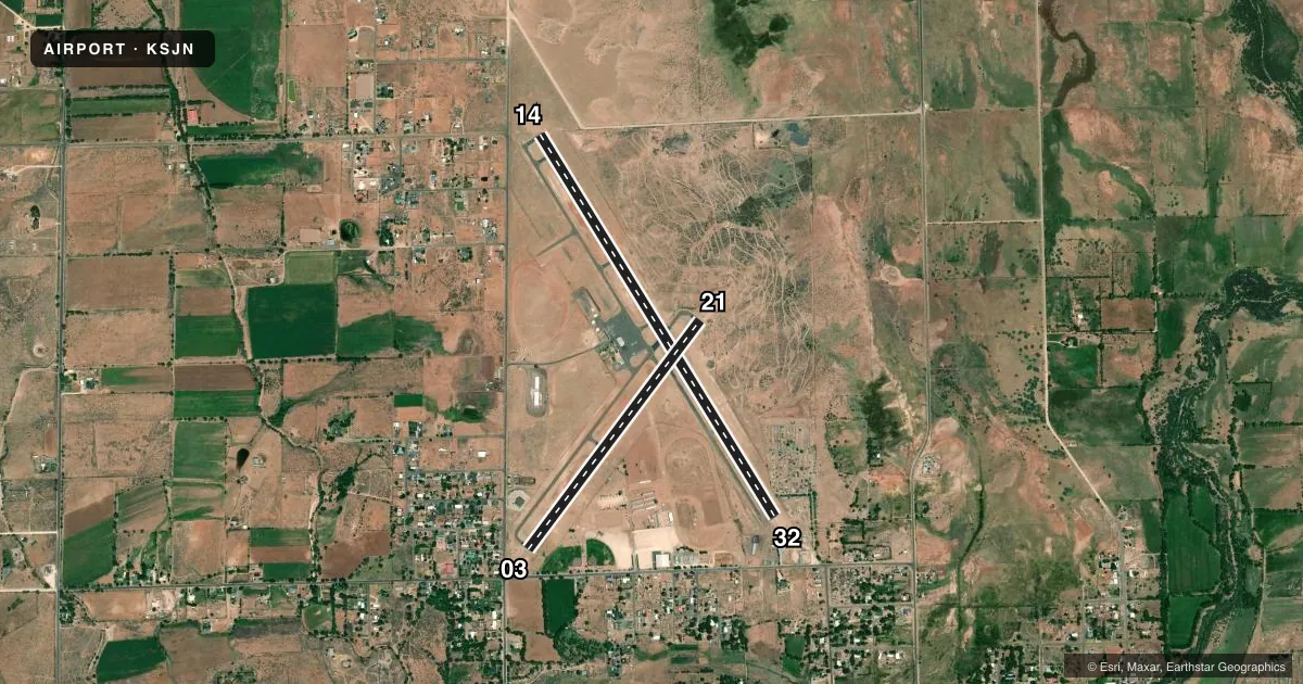
Runways & pattern
Full pagePattern entry · RWY 21
LEFT TRAFFIC| Runway | Heading (°M) | Length | Surface | Traffic |
|---|---|---|---|---|
| 14/32 | 136° / 316° | 5,322 ft | ASPH | Standard L |
| 03/21Favored | 25° / 205° | 3,400 ft | ASPH | Standard L |
Runway end performance
| End | TORA | TODA | ASDA | LDA | VGSI | Approach lights | Obstruction |
|---|---|---|---|---|---|---|---|
| 14 | — | — | — | — | PAPI 2-box left(3°) | — | — |
| 32 | — | — | — | — | PAPI 2-box right(3°) | — | 17', pole, 375' from thr, 135' R of cntrln, slope 10 |
| 03 | — | — | — | — | — | — | 58', tree, 440' from thr, 50' R of cntrln, slope 4 |
Declared distances in feet. TORA = takeoff run available, TODA = takeoff distance, ASDA = accelerate-stop, LDA = landing distance.
Airport sketch
Runways drawn to scale from FAA survey coordinates, rendered over satellite imagery. Not for navigation.
Approaches & charts
Services on the field
Fuel grades, oxygen, maintenance, ramp storage and lighting — as declared to the FAA by the airport operator.
Fuel & services
- Fuel
- 100LLA+
Ramp & ground
- Transient storage
- Tie-down
- Hangar
- Customs
- Not available
- Lighting schedule
- SEE RMK
- Beacon schedule
- SS-SR
- Beacon
- White / Green (civil land)(WG)
- Wind indicator
- Lighted
- Segmented circle
- Yes
Fuel & FBOs
Cheapest 100LL and Jet A on the field and nearby. Always confirm with the FBO before taxi.
Airport notes
Surface conditions, obstructions, local procedures, lighting outages and other notes published with each FAA cycle.
General notes
- MIL TFC INVOF ARPT.
- RWY 14/32 PARL TWY REFLECTORS FULL LEN BOTH SIDES.
- FOR CD IF UNA TO CTC ON FSS FREQ, CTC ALBUQUERQUE ARTCC AT 505-856-4561.
Lighting notes
- ACTVT REIL RWY 14 & 32; PAPI RWY 14 & 32; MIRL RWY 03/21 & 14/32 - CTAF.
Runway surface & condition
- 14/32RWY 32 CALM WIND RWY.
Approach & departure obstructions
- 215 FT DIRT PILE 100 FT FM THR 85 FT R OF CNTRLN.
- 320-12 FT FENCE 0-200 FT FM THR 135-150 FT R OF CNTRLN. +10 FT ROAD 0-150 FT FM RWY END ACRS THR.
- 03200 FT GRAVEL CLEAR AREA.
- 03FADED & MISG.
- 21FADED & MISG.
- 03APCH RATIO 10:1 TO DTHR; 58 FT TREE 630 FT FM RWY END 50 FT L OF CNTRLN.
- 32APCH RATIO 27:1 AT DTHR.
Other notes
- AVBL - AMGR.
- MANAGEREMERG - 928-245-0391
VFR map & nearby airports
VFR sectional. Tap any ICAO chip to open that airport.
Key facts · KSJN
Answer card- ICAO
- KSJN
- Name
- ST JOHNS INDUSTRIAL AIR PARK
- Location
- ST JOHNS, ARIZONA
- Elevation
- 5,736.5 ft MSL
- Traffic pattern altitude
- 6,736.5 ft MSL (1,000 AGL)
- Control tower
- Non-towered (use CTAF)
- Total runways
- 2
- Longest runway
- 14/32 · 5,322 ft
- Published ILS approaches
- 0
- Published frequencies
- 2
- Magnetic variation
- 12°
- Current flight rules
- VFR
- Current wind
- 270° at 5 kt
- Favored runway now
- RWY 21
St Johns Industrial Air Park is in St Johns, Arizona. The field elevation is 5,736.5 ft MSL. It has two asphalt runways. The longest is 14/32 at 5,322 ft. There is no control tower. CTAF and UNICOM are both 122.8. No ILS approaches are published.
Pattern altitude is not published. Use 1,000 ft AGL for light piston operations unless the current Chart Supplement says otherwise. That puts the standard pattern at 6,736.5 ft MSL. The airport sits in high terrain, so density altitude will matter on warm days. Plan for longer takeoff rolls and reduced climb performance.
The on-field FBO is St. Johns Industrial Air Park. It carries 100LL and Jet A. The airport remarks also note military traffic in the vicinity. Runway 14/32 has REILs, PAPI and medium intensity runway lights. Runways 03/21 and 14/32 have medium intensity runway lights. Lighting is controlled on the common traffic advisory frequency. There is also a transient storage hangar available through the airport manager.
First-time visitors should pay attention to the published runway remarks. Runway 03 has faded and missing markings. Runway 21 has faded and missing markings. Runway 32 has a fence and a road near the threshold. Check the current Chart Supplement and make a close visual inspection on arrival.