METAR & TAF 13Q
13Q does not publish a METAR.
Showing the nearest reporting station: KJTC (SPRINGERVILLE MUNI) · 32.3 NM away. Conditions at 13Q may differ.
METAR · KJTC
Observed 13:30Z
KJTC 271330Z AUTO 00000KT 10SM CLR 19/13 A3036 RMK AO2
- Wind
- 000° @ 0 kt
- Visibility
- 10 SM
- Temp / Dew
- 19°C / 13°C
- Altimeter
- 30.36 inHg
- Clouds
- CLR
- Density alt
- 9,459 ft
- Ceiling
- Unlimited
- Rules
- VFR
Airport info & contacts
Manager on record, flight service, ARTCC, attendance schedule and pattern altitude — published by the FAA and refreshed every 28 days.
Location
- From city
- 10 NM N
- VFR sectional
- ALBUQUERQUE
- ARTCC
- ZAB · ALBUQUERQUE
- NOTAM facility
- ABQ (NOTAM-D)
Airport manager
- Name
- RANDALL CHEVEZ
- Phone
- 575-773-4678
- Address
- PO BOX 159, QUEMADO NM 87829
Flight service · Hours
- FSS ABQ
- ALBUQUERQUE1-800-WX-BRIEF
- Attendance
- Unattended
Frequencies
Tap any row to copy the frequency to your clipboard.
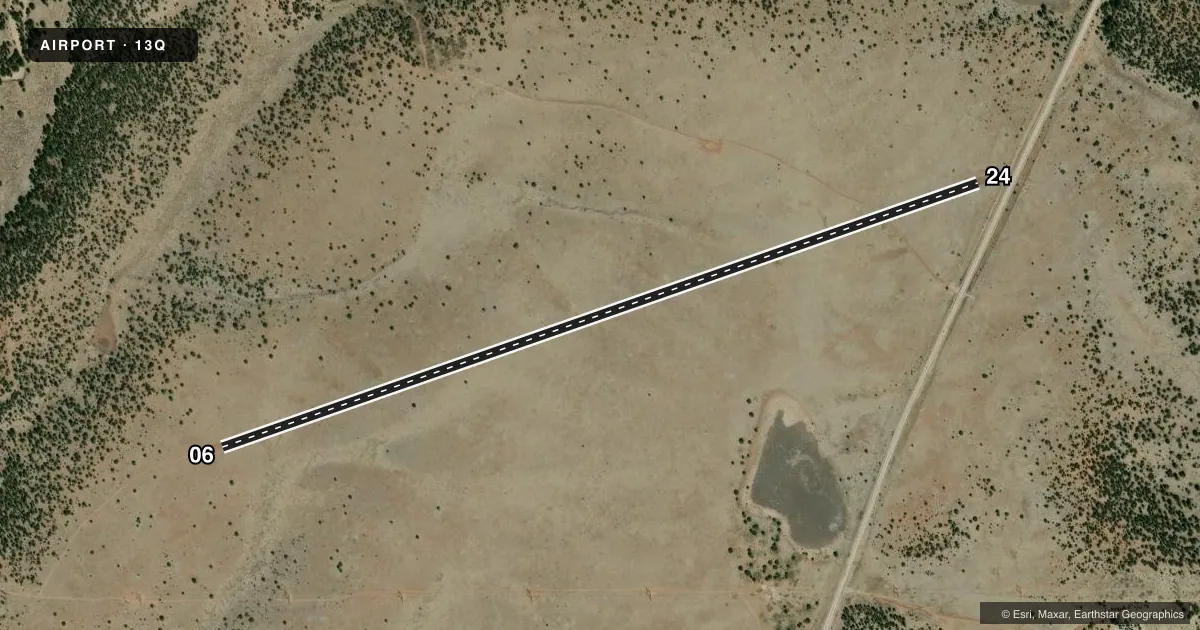
Runways & pattern
Full pagePattern entry · RWY 06
LEFT TRAFFICRunway end performance
| End | TORA | TODA | ASDA | LDA | VGSI | Approach lights | Obstruction |
|---|---|---|---|---|---|---|---|
| 06 | — | — | — | — | — | — | 75', pline, 1183' from thr, 104' R of cntrln, slope 15 |
| 24 | — | — | — | — | — | — | 4', fence, 55' from thr, 125' R of cntrln, slope 13 |
Declared distances in feet. TORA = takeoff run available, TODA = takeoff distance, ASDA = accelerate-stop, LDA = landing distance.
Airport sketch
Runways drawn to scale from FAA survey coordinates, rendered over satellite imagery. Not for navigation.
Approaches & charts
Services on the field
Fuel grades, oxygen, maintenance, ramp storage and lighting — as declared to the FAA by the airport operator.
Fuel & services
- Fuel
- Not available
Ramp & ground
- Transient storage
- Not published
- Landing fee
- No fee published
- Wind indicator
- Yes
- Segmented circle
- No
Fuel & FBOs
Cheapest 100LL and Jet A on the field and nearby. Always confirm with the FBO before taxi.
Airport notes
Surface conditions, obstructions, local procedures, lighting outages and other notes published with each FAA cycle.
General notes
- RCMND VISUAL INSP BFR USE. WILDLIFE & LIVESTOCK ON RWY. CONFIRM RWY COND PRIOR TO LNDG - 1-800-538-1644.
- CLSD WINTER MONTHS.
- FOR CD CTC ALBUQUERQUE ARTCC AT 505-856-4861.
Runway surface & condition
- 06/24ACES ROAD CROSSES RWY NEAR ENTRANCE ROAD. LRG ROCKS 30-45 FT FM CNTRLN BOTH SIDES ENTIRE LEN.
Approach & departure obstructions
- 06RY MRKD WITH TIRES 28 FT. LEFT AND 33 FT. RIGHT OF CNTRLN.
- 24RY MARKED WITH SINGLE TIRES 30 FT. LEFT AND RIGHT OF CENTERLINE.
Other notes
- ARPT OPEN MAY-SEP; OTHER TIMES CLSD.
- MANAGERDISTRICT RANGER
- 06/24RWY 6-24 ROUGH WITH SOME SCATTERED ROCKS AND VEGETATION.
VFR map & nearby airports
VFR sectional. Tap any ICAO chip to open that airport.
Key facts · 13Q
Answer card- ICAO
- 13Q
- Name
- JEWETT MESA
- Location
- APACHE CREEK, NEW MEXICO
- Elevation
- 7,681 ft MSL
- Traffic pattern altitude
- 8,681 ft MSL (1,000 AGL)
- Control tower
- Non-towered (use CTAF)
- Total runways
- 1
- Longest runway
- 06/24 · 5,200 ft
- Published ILS approaches
- 0
- Published frequencies
- 1
- Magnetic variation
- 12°
- Current flight rules
- VFR
- Current wind
- 000° at 0 kt
- Favored runway now
- –
Jewett Mesa sits at Apache Creek, New Mexico. Field elevation is 7,681 ft MSL. The airport has one runway. Runway 06/24 is 5,200 ft long and is dirt. There is no control tower. No ILS approaches are published. Pattern altitude is not published, so use standard 1,000 ft AGL unless local guidance says otherwise.
This is a high-elevation strip. That matters for performance. Expect thinner air and plan your takeoff and landing distances with care. The field is also seasonal. It is open May through September. It is closed at other times, including the winter months. The runway remarks are not casual. Aces Road crosses near the entrance road. Large rocks sit close to both sides of the runway. The surface is reported as extremely rough with ruts, rocks and vegetation. Wildlife and livestock may be on the runway. A visual inspection before use is recommended. Confirm runway condition before landing by calling 1-800-538-1644.
No on-field FBOs are listed. CTAF is 122.9. For clearance delivery, contact Albuquerque ARTCC at 505-856-4861. If you are planning a first visit, treat this as a remote backcountry-style field. Verify current conditions before you go. The airport manager is the district ranger.