METAR & TAF KXNI
Current METAR
Observed 20:15Z
KXNI 262015Z AUTO 19010KT 10SM CLR 33/12 A3026 RMK AO2 LTG DSNT N AND NE
- Wind
- 190° @ 10 kt
- Visibility
- 10 SM
- Temp / Dew
- 33°C / 12°C
- Altimeter
- 30.26 inHg
- Clouds
- CLR
- Density alt
- 9,639 ft
- Ceiling
- Unlimited
- Rules
- VFR
Airport info & contacts
Manager on record, flight service, ARTCC, attendance schedule and pattern altitude — published by the FAA and refreshed every 28 days.
Location
- From city
- 4 NM W
- VFR sectional
- ALBUQUERQUE
- ARTCC
- ZAB · ALBUQUERQUE
- NOTAM facility
- XNI (NOTAM-D)
Airport manager
- Name
- ROYCE GCHACHU
- Phone
- 505-870-8533
- Address
- PO BOX 339, ZUNI NM 87327-0339
Flight service · Hours
- FSS ABQ
- ALBUQUERQUE1-800-WX-BRIEF
- Attendance
- Unattended
Frequencies
Tap any row to copy the frequency to your clipboard.
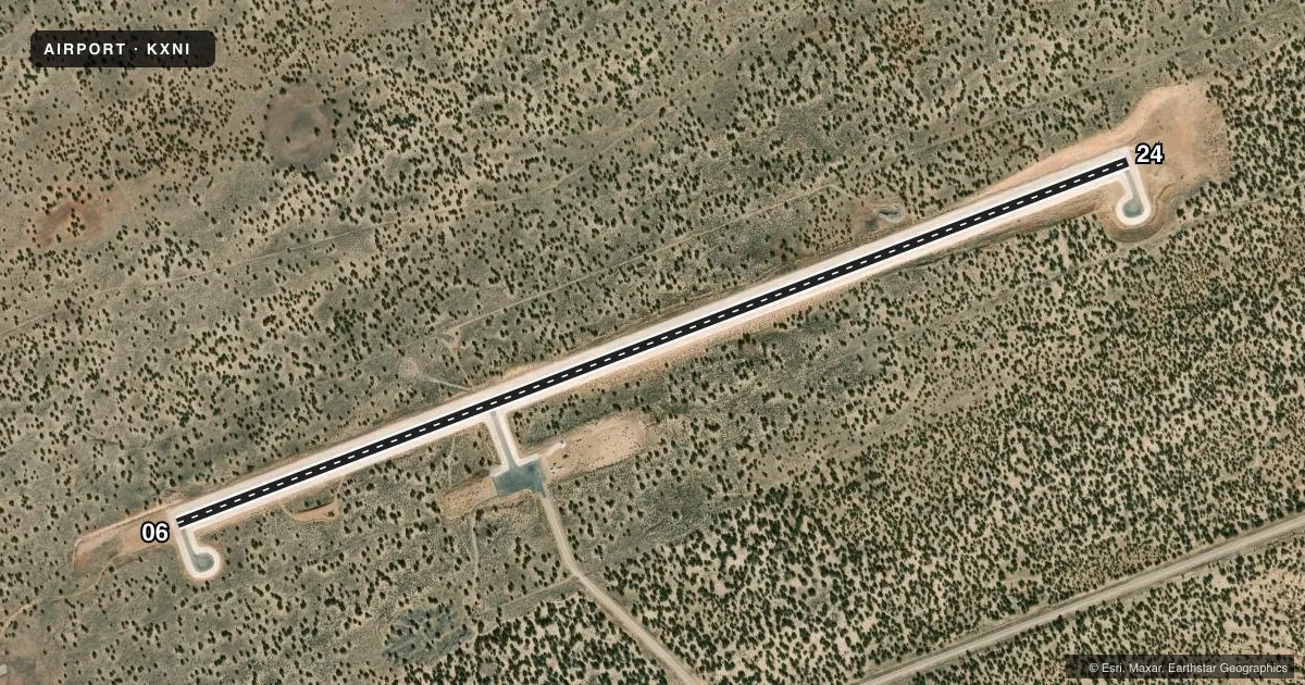
Runways & pattern
Full pagePattern entry · RWY 24
LEFT TRAFFICAirport sketch
Runways drawn to scale from FAA survey coordinates, rendered over satellite imagery. Not for navigation.
Approaches & charts
Services on the field
Fuel grades, oxygen, maintenance, ramp storage and lighting — as declared to the FAA by the airport operator.
Fuel & services
- Fuel
- Not available
Ramp & ground
- Transient storage
- Tie-down
- Lighting schedule
- SEE RMK
- Beacon schedule
- SS-SR
- Beacon
- White / Green (civil land)(WG)
- Wind indicator
- Lighted
Fuel & FBOs
Cheapest 100LL and Jet A on the field and nearby. Always confirm with the FBO before taxi.
Airport notes
Surface conditions, obstructions, local procedures, lighting outages and other notes published with each FAA cycle.
General notes
- BOTH GATES ACES: 5149.
- FOR CD CTC ALBUQUERQUE ARTCC AT 505-856-4861.
- RAMP LGT SWITCHES ON POST BY ROADWAY.
Lighting notes
- ACTVT MIRL RWY 06/24 - CTAF.
Other notes
- MANAGERALTN CTC: LENNY CHUYATE 505-906-4002.
VFR map & nearby airports
VFR sectional. Tap any ICAO chip to open that airport.
Key facts · KXNI
Answer card- ICAO
- KXNI
- Name
- ANDREW OTHOLE MEML
- Location
- ZUNI, NEW MEXICO
- Elevation
- 6,371.2 ft MSL
- Traffic pattern altitude
- 7,371.2 ft MSL (1,000 AGL)
- Control tower
- Non-towered (use CTAF)
- Total runways
- 1
- Longest runway
- 06/24 · 6,000 ft
- Published ILS approaches
- 0
- Published frequencies
- 1
- Magnetic variation
- 9°
- Current flight rules
- VFR
- Current wind
- 190° at 10 kt
- Favored runway now
- RWY 24
Andrew Othole Meml sits in Zuni, New Mexico. The field elevation is 6,371.2 ft MSL. It has one runway. Runway 06/24 is 6,000 ft asphalt. There is no control tower. CTAF is 122.9.
No ILS approaches are published here. Pattern altitude is not published, so use the current FAA Chart Supplement before you go. For light piston traffic, a standard 1,000 ft AGL pattern is often used when no local value is published, but verify the current procedure before arrival. The runway lights for 06/24 are medium intensity and are activated by the CTAF. Ramp light switches are on the post by the roadway. Both gates use access code 5149.
There are no on-field FBOs listed. Contact the airport operator directly or call the field on CTAF for current services before you launch. Clearance delivery is handled through Albuquerque ARTCC at 505-856-4861. At this elevation, expect high-density-altitude performance to matter on warm days. Plan your takeoff and climb with that in mind. The runway length is workable for many light aircraft. Performance planning still matters in the high desert.