METAR & TAF KRQE
Current METAR
Observed 12:53Z
KRQE 271253Z AUTO 00000KT 10SM CLR 15/14 A3030 RMK AO2 SLP146 T01500139 $
- Wind
- 000° @ 0 kt
- Visibility
- 10 SM
- Temp / Dew
- 15°C / 14°C
- Altimeter
- 30.30 inHg
- Clouds
- CLR
- Density alt
- 7,889 ft
- Ceiling
- Unlimited
- Rules
- VFR
Airport info & contacts
Manager on record, flight service, ARTCC, attendance schedule and pattern altitude — published by the FAA and refreshed every 28 days.
Location
- From city
- 1 NM S
- VFR sectional
- DENVER
- ARTCC
- ZAB · ALBUQUERQUE
- NOTAM facility
- RQE (NOTAM-D)
Airport manager
- Name
- KYRON HARDY
- Phone
- 505-371-8323
- Address
- P.O. BOX 706, WINDOW ROCK AZ 86515
Flight service · Hours
- FSS PRC
- PRESCOTT1-800-WX-BRIEF
- Attendance
- MON-FRI · 0800-1700
Frequencies
Tap any row to copy the frequency to your clipboard.
Runways & pattern
Full pagePattern entry · RWY 03
LEFT TRAFFICRunway end performance
| End | TORA | TODA | ASDA | LDA | VGSI | Approach lights | Obstruction |
|---|---|---|---|---|---|---|---|
| 03 | — | — | — | — | PAPI 2-box left(3°) | — | 5', fence, 202' from thr, 0' R of cntrln, slope 0 |
Declared distances in feet. TORA = takeoff run available, TODA = takeoff distance, ASDA = accelerate-stop, LDA = landing distance.
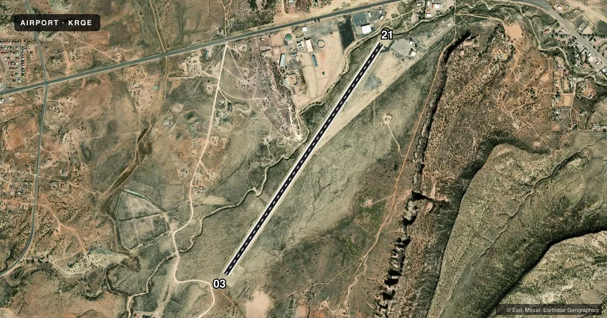
Airport sketch
Runways drawn to scale from FAA survey coordinates, rendered over satellite imagery. Not for navigation.
Approaches & charts
Services on the field
Fuel grades, oxygen, maintenance, ramp storage and lighting — as declared to the FAA by the airport operator.
Fuel & services
- Fuel
- Not available
Ramp & ground
- Transient storage
- Tie-down
- Landing fee
- No fee published
- Customs
- Not available
- Lighting schedule
- SEE RMK
- Beacon schedule
- SS-SR
- Beacon
- Yellow(Y)
- Wind indicator
- Lighted
- Segmented circle
- No
Fuel & FBOs
Cheapest 100LL and Jet A on the field and nearby. Always confirm with the FBO before taxi.
Airport notes
Surface conditions, obstructions, local procedures, lighting outages and other notes published with each FAA cycle.
General notes
- TRRN ALL QUADS.
- CTN: TURB INVOF ARPT.
- FOR CD CTC ALBUQUERQUE ARTCC AT 505-856-4861.
Lighting notes
- ACTVT REIL RWY 03 & 21; MIRL RWY 03/21 - CTAF.
Runway surface & condition
- 03/21RWY 03 TURN AROUND UNUSBL.
Approach & departure obstructions
- 03+6 FT FENCE 0-200 FT FM THR 125 FT L OF CNTRLN.
- 214 FT FENCE 200 FT FM THR BOTH SIDES.
- 03FADED OR MISG.
- 03CTLG OBS EXCEEDS 45 DEG SLOPE.
Other notes
- THIS AIRPORT HAS BEEN SURVEYED BY THE NATIONAL GEODETIC SURVEY.
- 03/21S HALF ROUGH.
VFR map & nearby airports
VFR sectional. Tap any ICAO chip to open that airport.
Key facts · KRQE
Answer card- ICAO
- KRQE
- Name
- WINDOW ROCK
- Location
- WINDOW ROCK, ARIZONA
- Elevation
- 6,742 ft MSL
- Traffic pattern altitude
- 7,742 ft MSL (1,000 AGL)
- Control tower
- Non-towered (use CTAF)
- Total runways
- 1
- Longest runway
- 03/21 · 7,000 ft
- Published ILS approaches
- 0
- Published frequencies
- 2
- Magnetic variation
- 9°
- Current flight rules
- VFR
- Current wind
- 000° at 0 kt
- Favored runway now
- –
Window Rock Airport (KRQE) sits in Window Rock, Arizona. Field elevation is 6,742 ft MSL. The airport has one runway, 03/21, which is 7,000 ft asphalt. It is a non-towered field. CTAF and UNICOM are both 122.8. No ILS approaches are published.
Pattern altitude is not published. Use the standard 1,000 ft AGL pattern unless local guidance says otherwise. That puts the light piston pattern around 7,742 ft MSL. The field sits in terrain in all quadrants. Expect turbulence near the airport. The airport is surveyed by the National Geodetic Survey. Runway 03 has a 6 ft fence near the threshold on the left side. Runway 21 has 4 ft fences near the threshold on both sides. The south half of runway 03/21 is rough. Runway 03 markings are faded or missing. Runway 03 turn around is unusable.
There are no on-field FBOs listed. Plan on confirming services with the airport operator before arrival. For clearance delivery, contact Albuquerque ARTCC at 505-856-4861. The runway lights and REILs on 03 and 21 are pilot controlled on CTAF.