METAR & TAF 0E8
0E8 does not publish a METAR.
Showing the nearest reporting station: KGUP (GALLUP MUNI) · 31.3 NM away. Conditions at 0E8 may differ.
METAR · KGUP
Observed 21:53Z
KGUP 262153Z AUTO 10006KT 10SM CLR 26/13 A3026 RMK AO2 LTG DSNT W SLP069 T02560133
- Wind
- 100° @ 6 kt
- Visibility
- 10 SM
- Temp / Dew
- 26°C / 13°C
- Altimeter
- 30.26 inHg
- Clouds
- CLR
- Density alt
- 9,201 ft
- Ceiling
- Unlimited
- Rules
- VFR
Airport info & contacts
Manager on record, flight service, ARTCC, attendance schedule and pattern altitude — published by the FAA and refreshed every 28 days.
Location
- From city
- 3 NM NW
- VFR sectional
- DENVER
- ARTCC
- ZAB · ALBUQUERQUE
- NOTAM facility
- ABQ (NOTAM-D)
Airport manager
- Name
- TOM PLATERO
- Phone
- 505-371-8354
- Address
- PO BOX 4620, WINDOW ROCK AZ 86515
Flight service · Hours
- FSS ABQ
- ALBUQUERQUE1-800-WX-BRIEF
- Attendance
- Unattended
Frequencies
Tap any row to copy the frequency to your clipboard.
Runways & pattern
Full pagePattern entry · RWY 36
LEFT TRAFFICRunway end performance
| End | TORA | TODA | ASDA | LDA | VGSI | Approach lights | Obstruction |
|---|---|---|---|---|---|---|---|
| 18 | — | — | — | — | PSIL(3°) | — | — |
Declared distances in feet. TORA = takeoff run available, TODA = takeoff distance, ASDA = accelerate-stop, LDA = landing distance.
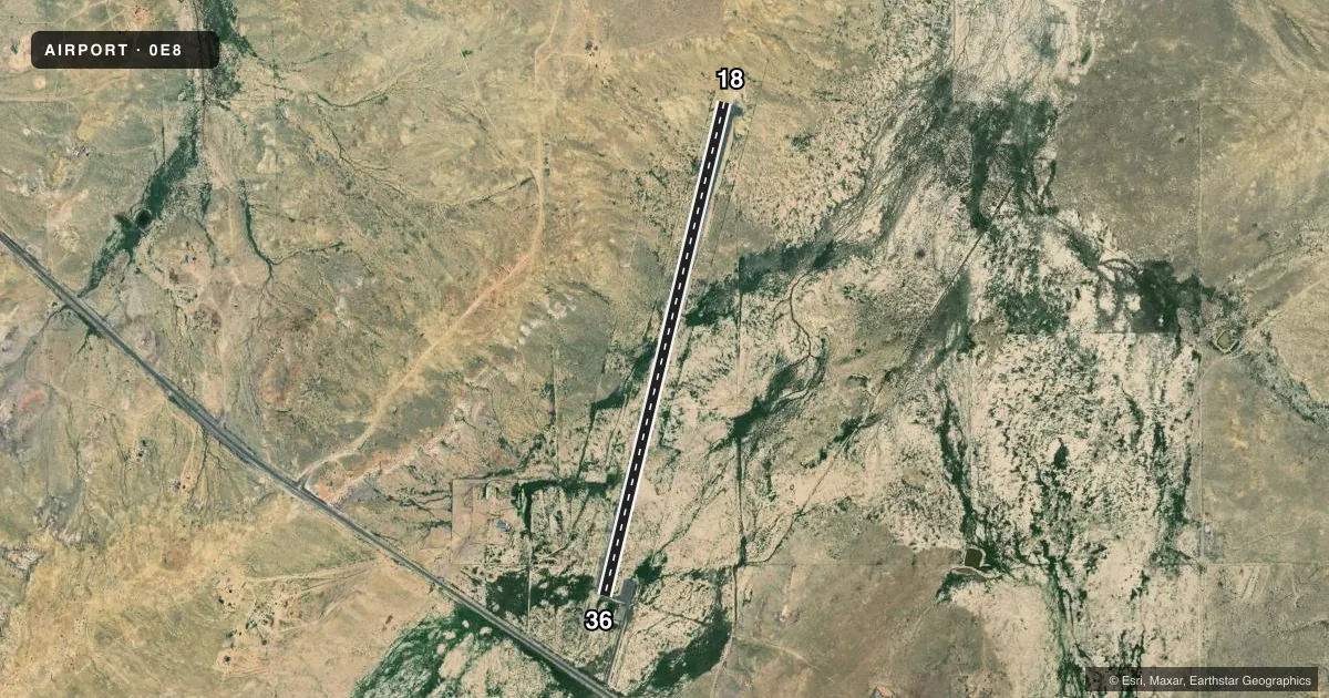
Airport sketch
Runways drawn to scale from FAA survey coordinates, rendered over satellite imagery. Not for navigation.
Approaches & charts
Services on the field
Fuel grades, oxygen, maintenance, ramp storage and lighting — as declared to the FAA by the airport operator.
Fuel & services
- Fuel
- Not available
Ramp & ground
- Transient storage
- Not published
- Landing fee
- No fee published
- Lighting schedule
- SEE RMK
- Beacon schedule
- SS-SR
- Beacon
- White / Green (civil land)(WG)
- Wind indicator
- Lighted
- Segmented circle
- Yes
Fuel & FBOs
Cheapest 100LL and Jet A on the field and nearby. Always confirm with the FBO before taxi.
Airport notes
Surface conditions, obstructions, local procedures, lighting outages and other notes published with each FAA cycle.
General notes
- WILDLIFE ON OR INVOF ARPT.
Lighting notes
- ACTVT MIRL RWY 18/36 - 122.9.
Approach & departure obstructions
- 18+8 FT BERM 0-200 FT FM THR 81 FT R.
- 18FADED OR MISSING.
- 36FADED OR MISSING.
Other notes
- PRVDD RWY LCTD TO PRVD 20:1 APCH/DEP CLNC OVER ELECTRICAL TRANSMISSION LINE SOUTH END.
VFR map & nearby airports
VFR sectional. Tap any ICAO chip to open that airport.
Key facts · 0E8
Answer card- ICAO
- 0E8
- Name
- CROWNPOINT
- Location
- CROWNPOINT, NEW MEXICO
- Elevation
- 6,696 ft MSL
- Traffic pattern altitude
- 7,696 ft MSL (1,000 AGL)
- Control tower
- Non-towered (use CTAF)
- Total runways
- 1
- Longest runway
- 18/36 · 5,820 ft
- Published ILS approaches
- 0
- Published frequencies
- 1
- Magnetic variation
- 12°
- Current flight rules
- VFR
- Current wind
- 100° at 6 kt
- Favored runway now
- RWY 36
Crownpoint Airport (0E8) is in Crownpoint, New Mexico. The field elevation is 6,696 ft MSL. It has one runway. Runway 18/36 is 5,820 ft long with an asphalt surface. There is no control tower. CTAF is 122.9.
No ILS approaches are published here. The pattern altitude is not published, so use the standard 1,000 ft AGL unless the current Chart Supplement says otherwise. At this elevation, performance planning matters. Density altitude can get high fast. Expect longer takeoff rolls and reduced climb. The published remarks also call out runway environment details that matter on short final. There is an 8-foot berm near the south end of the field. The runway location is set to protect 20 to 1 clearance over the electrical transmission line at the south end. Wildlife is also reported on or near the airport.
There are no on-field FBOs listed. Plan on confirming services with the airport operator or the FBO directly by phone before you go. Runway 18 and runway 36 markings are faded or missing. The runway lights for 18/36 are medium intensity and are activated on 122.9. That makes a radio check on CTAF important if you expect to arrive after dark.