METAR & TAF NM2
NM2 does not publish a METAR.
Showing the nearest reporting station: KLAM (LOS ALAMOS) · 33.8 NM away. Conditions at NM2 may differ.
METAR · KLAM
Observed 03:35Z
KLAM 270335Z AUTO 27004KT 10SM BKN110 OVC130 28/10 A3027 RMK AO2 T02780101 PWINO $
- Wind
- 270° @ 4 kt
- Visibility
- 10 SM
- Temp / Dew
- 28°C / 10°C
- Altimeter
- 30.27 inHg
- Clouds
- OVC
- Density alt
- 9,608 ft
- Ceiling
- 11,000 ft AGL
- Rules
- VFR
Airport info & contacts
Manager on record, flight service, ARTCC, attendance schedule and pattern altitude — published by the FAA and refreshed every 28 days.
Location
- From city
- 4 NM S
- VFR sectional
- DENVER
- ARTCC
- ZAB · ALBUQUERQUE
- NOTAM facility
- ABQ (NOTAM-D)
Airport manager
- Name
- JACKIE LEYBA
- Phone
- 505-249-8548
- Address
- 100 SUN AVE NE SUITE 330, ALBUQUERQUE NM 87109
Flight service · Hours
- FSS ABQ
- ALBUQUERQUE1-800-WX-BRIEF
- Attendance
- UNATTENDED
Frequencies
Tap any row to copy the frequency to your clipboard.
Runways & pattern
Full pagePattern entry · RWY 24
LEFT TRAFFICRunway end performance
| End | TORA | TODA | ASDA | LDA | VGSI | Approach lights | Obstruction |
|---|---|---|---|---|---|---|---|
| 06 | — | — | — | — | — | — | 3', brush, 0' from thr, 20' R of cntrln, slope 0 |
| 24 | — | — | — | — | — | — | 3', brush, 0' from thr, 20' R of cntrln, slope 0 |
Declared distances in feet. TORA = takeoff run available, TODA = takeoff distance, ASDA = accelerate-stop, LDA = landing distance.
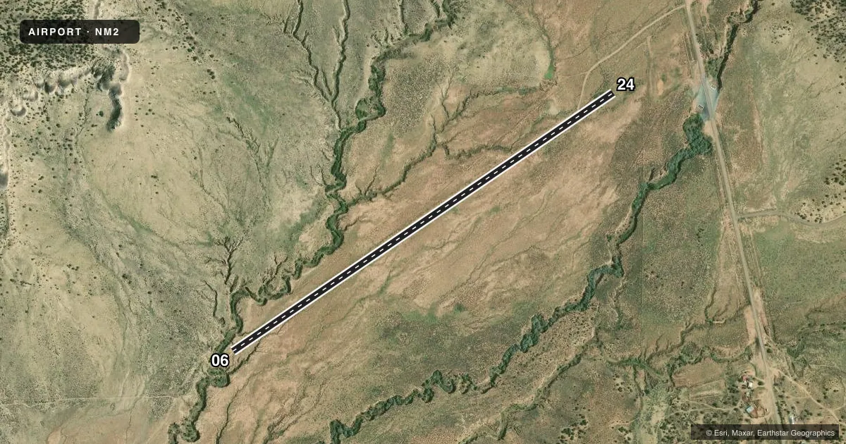
Airport sketch
Runways drawn to scale from FAA survey coordinates, rendered over satellite imagery. Not for navigation.
Approaches & charts
Services on the field
Fuel grades, oxygen, maintenance, ramp storage and lighting — as declared to the FAA by the airport operator.
Fuel & services
- Fuel
- Not available
Ramp & ground
- Transient storage
- Not published
- Wind indicator
- Yes
- Segmented circle
- No
Fuel & FBOs
Cheapest 100LL and Jet A on the field and nearby. Always confirm with the FBO before taxi.
Airport notes
Surface conditions, obstructions, local procedures, lighting outages and other notes published with each FAA cycle.
General notes
- LIVESTOCK, ELK & DEER ON OR INVOF ARPT.
- USE CTAF WITHIN 5 NM OF ARPT.
Approach & departure obstructions
- 06CTLG OBSTN EXCEEDS A 45 DEG SLOPE.
Other notes
- MANAGERACTING FLD MGR FOR THE PUERCO FLD OFC.
- 06/242-4 IN SCATTERED ROCK & 3-5 IN RUTTS DUE TO VEHICLE TFC ON RWY.
VFR map & nearby airports
VFR sectional. Tap any ICAO chip to open that airport.
Key facts · NM2
Answer card- ICAO
- NM2
- Name
- CUBA LANDING STRIP
- Location
- CUBA, NEW MEXICO
- Elevation
- 6,840 ft MSL
- Traffic pattern altitude
- 7,840 ft MSL (1,000 AGL)
- Control tower
- Non-towered (use CTAF)
- Total runways
- 1
- Longest runway
- 06/24 · 4,137 ft
- Published ILS approaches
- 0
- Published frequencies
- 1
- Magnetic variation
- 9°
- Current flight rules
- VFR
- Current wind
- 270° at 4 kt
- Favored runway now
- RWY 24
Cuba Landing Strip sits in Cuba, New Mexico. The field elevation is 6,840 ft MSL. It has one runway. Runway 06/24 is 4,137 ft long and is dirt. The airport is uncontrolled. CTAF is 122.9. No ILS approaches are published here. The pattern altitude is not published. Use the standard 1,000 ft AGL pattern unless the current Chart Supplement says otherwise.
This is a high-elevation strip. Expect performance to be different than you are used to at lower fields. The published remarks also call out scattered rock and ruts on the runway from vehicle traffic. There is also an obstruction near runway 06 that exceeds a 45 degree slope. Livestock, elk and deer may be on or near the airport, so keep a sharp lookout on arrival and departure.
No on-field FBOs are listed. Plan on self-sufficiency and verify current field status with the airport operator before you go. Use the common traffic advisory frequency within 5 nautical miles of the airport. For a first trip, the main things to brief are the dirt surface, the high density altitude risk, the wildlife and the runway condition near 06.