METAR & TAF KLAM
Current METAR
Observed 14:55Z
KLAM 271455Z AUTO VRB06KT 10SM CLR 24/11 A3031 RMK AO2 T02400111 53006 $
- Wind
- VAR @ 6 kt
- Visibility
- 10 SM
- Temp / Dew
- 24°C / 11°C
- Altimeter
- 30.31 inHg
- Clouds
- CLR
- Density alt
- 9,488 ft
- Ceiling
- Unlimited
- Rules
- VFR
Airport info & contacts
Manager on record, flight service, ARTCC, attendance schedule and pattern altitude — published by the FAA and refreshed every 28 days.
Location
- From city
- 1 NM E
- VFR sectional
- DENVER
- ARTCC
- ZAB · ALBUQUERQUE
- NOTAM facility
- LAM (NOTAM-D)
Airport manager
- Name
- GARY GODDARD
- Phone
- 505-709-8687
- Address
- 1040 AIRPORT RD, LOS ALAMOS NM 87544-3308
Flight service · Hours
- FSS ABQ
- ALBUQUERQUE1-800-WX-BRIEF
- Attendance
- MON-FRI · 0800-1700
Frequencies
Tap any row to copy the frequency to your clipboard.
Runways & pattern
Full pagePattern entry · RWY 27
RIGHT TRAFFICRunway end performance
| End | TORA | TODA | ASDA | LDA | VGSI | Approach lights | Obstruction |
|---|---|---|---|---|---|---|---|
| 09 | — | — | — | — | — | — | 8', fence, 201' from thr, 145' R of cntrln, slope 0 |
| 27 | — | — | — | — | PAPI 2-box left(3°) | — | — |
Declared distances in feet. TORA = takeoff run available, TODA = takeoff distance, ASDA = accelerate-stop, LDA = landing distance.
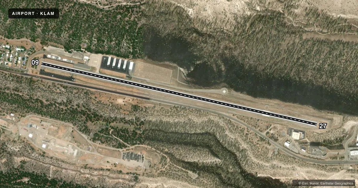
Airport sketch
Runways drawn to scale from FAA survey coordinates, rendered over satellite imagery. Not for navigation.
Approaches & charts
Services on the field
Fuel grades, oxygen, maintenance, ramp storage and lighting — as declared to the FAA by the airport operator.
Fuel & services
- Fuel
- 100LLA1+
- Airframe repair
- Not available
- Power plant repair
- Not available
Ramp & ground
- Transient storage
- Tie-down
- Landing fee
- No fee published
- Lighting schedule
- SEE RMK
- Beacon schedule
- SS-SR
- Beacon
- White / Green (civil land)(WG)
- Wind indicator
- Lighted
- Segmented circle
- Yes
Fuel & FBOs
Cheapest 100LL and Jet A on the field and nearby. Always confirm with the FBO before taxi.
Airport notes
Surface conditions, obstructions, local procedures, lighting outages and other notes published with each FAA cycle.
General notes
- RADIO COMM RCMDD BFR TFC PAT ENTRY.
- RSTRD AREA ADJ TO S SIDE OF ARPT.
- WILDLIFE ON & INVOF ARPT.
- ARFF INDEX B AVBL; 24 HR PPR.
- FOR CD CTC ALBUQUERQUE ARTCC AT 505-856-4861.
Lighting notes
- ACTVT REILS RWY 27; MIRL RWY 09/27 - CTAF.
Fuel notes
- 100LL100LL AND JET-A FUEL SVC AVBL 24 HRS WITH MAJ CREDIT CARD.
Runway surface & condition
- 09/27LND W; TKOF E.
Approach & departure obstructions
- 09+8 FT BLAST BARRIER 75 FT FM THR 50 FT L & R OF CNTRLN; +25 FT LIGHT POLE 198 FT FM THR 135 FT L OF CNTRLN; +4-15 FT BRUSH & TREES 80-200 FT FM THR 125 FT L & R OF CNTRLN.
- 27VFR TFC RMN 5 MI E OF ARPT TIL TURNING FINAL; R TURN ON GO AROUND OR MISSED APCH.
- 271.5 UP TO W.
- 09CTLG OBSTN EXCEEDS A 45 DEG SLOPE.
Other notes
- PRVDD APCH SLOPES TO RWY ENDS AT LEAST 20:1 & EXCEPTIONS TO THE ONE WAY OPNS ARE PRVDD IN THE CASE OF ADVERSE TAIL WINDS WHICH WOULD EXCEED A GIVEN ACFT'S TAIL WIND LIMITATIONS.
- TIE DOWNS AVBL ON RAMP NEAR FUEL FARM.
- 1CLOSED HOL; AFT HRS - 505-709-8687.
VFR map & nearby airports
VFR sectional. Tap any ICAO chip to open that airport.
Key facts · KLAM
Answer card- ICAO
- KLAM
- Name
- LOS ALAMOS
- Location
- LOS ALAMOS, NEW MEXICO
- Elevation
- 7,170.9 ft MSL
- Traffic pattern altitude
- 8,170.9 ft MSL (1,000 AGL)
- Control tower
- Non-towered (use CTAF)
- Total runways
- 1
- Longest runway
- 09/27 · 6,000 ft
- Published ILS approaches
- 0
- Published frequencies
- 2
- Magnetic variation
- 10°
- Current flight rules
- VFR
- Current wind
- 000° at 6 kt
- Favored runway now
- RWY 27
Los Alamos Airport (KLAM) is in Los Alamos, New Mexico. The field elevation is 7,170.9 ft MSL. It has one runway, 09/27, which is 6,000 ft long. There is no control tower. CTAF and UNICOM are both 123.0. No ILS approaches are published here.
The pattern altitude is not published, so use the standard 1,000 ft AGL for light piston operations unless the current FAA Chart Supplement says otherwise. That puts you at about 8,170.9 ft MSL. Los Alamos Avgas is on the field. It carries 100LL and Jet A. Fuel service is listed as available 24 hours with a major credit card. The airport also notes that runway 27 has runway end identifier lights and medium intensity runway lighting on 09/27 is CTAF controlled.
This is a high-elevation field, so performance planning matters. The published remarks also call out wildlife on and near the airport. There are obstacles near runway 09, including a blast barrier, a light pole and brush and trees close to the threshold. Runway 27 has a 1.5 percent upslope to the west. Radio contact is recommended before entering the pattern. Clearance delivery is handled through Albuquerque ARTCC. Check the current FAA Chart Supplement for any current restrictions. A restricted area lies south of the airport.