METAR & TAF KSAF
Current METAR
Observed 07:53Z
KSAF 270753Z AUTO 36018G28KT 10SM CLR 23/12 A3022 RMK AO2 PK WND 34030/0718 SLP102 T02280122
- Wind
- 360° @ 18G28 kt
- Visibility
- 10 SM
- Temp / Dew
- 23°C / 12°C
- Altimeter
- 30.22 inHg
- Clouds
- CLR
- Density alt
- 8,460 ft
- Ceiling
- Unlimited
- Rules
- VFR
Airport info & contacts
Manager on record, flight service, ARTCC, attendance schedule and pattern altitude — published by the FAA and refreshed every 28 days.
Location
- From city
- 9 NM SW
- VFR sectional
- ALBUQUERQUE
- ARTCC
- ZAB · ALBUQUERQUE
- NOTAM facility
- SAF (NOTAM-D)
Airport manager
- Name
- JIMMY GUNN
- Phone
- 505-955-2910
- Address
- 121 AVIATION DR, SANTA FE NM 87507-0909
Flight service · Hours
- FSS ABQ
- ALBUQUERQUE1-800-WX-BRIEF
- Attendance
- 0600-2200
Frequencies
Tap any row to copy the frequency to your clipboard.
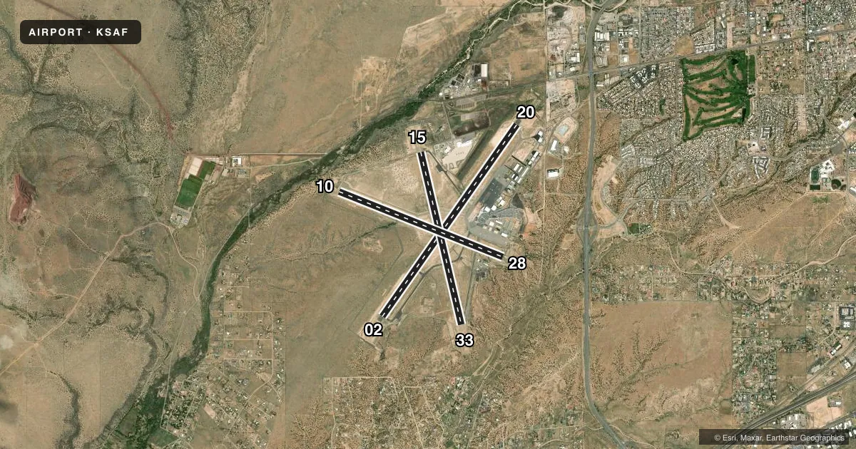
Runways & pattern
Full pagePattern entry · RWY 33
LEFT TRAFFIC| Runway | Heading (°M) | Length | Surface | Traffic |
|---|---|---|---|---|
| 02/20 | 27° / 207° | 8,366 ft | ASPH | Standard L |
| 15/33Favored | 159° / 339° | 6,316 ft | ASPH | Standard L |
| 10/28 | 104° / 284° | 6,301 ft | ASPH | Standard L |
Runway end performance
| End | TORA | TODA | ASDA | LDA | VGSI | Approach lights | Obstruction |
|---|---|---|---|---|---|---|---|
| 02 | — | — | — | — | VASI 4-box left(3°) | — | 6', hill, 225' from thr, 226' R of cntrln, slope 4 |
| 20 | — | — | — | — | VASI 4-box left(3°) | — | — |
| 15 | 6,316' | 6,316' | 5,221' | 5,221' | — | — | — |
| 33 | — | — | — | — | VASI 4-box right(3°) | — | — |
| 28 | — | — | — | — | — | — | 11', road, 250' from thr, 260' R of cntrln, slope 4 |
Declared distances in feet. TORA = takeoff run available, TODA = takeoff distance, ASDA = accelerate-stop, LDA = landing distance.
Airport sketch
Runways drawn to scale from FAA survey coordinates, rendered over satellite imagery. Not for navigation.
Approaches & charts
ILS · 1
Services on the field
Fuel grades, oxygen, maintenance, ramp storage and lighting — as declared to the FAA by the airport operator.
Fuel & services
- Fuel
- 100LLAA+
- Oxygen (bottled)
- HIGH/LOW
- Oxygen (bulk)
- HIGH/LOW
- Airframe repair
- Major
- Power plant repair
- Major
- Other services
- AMB,AVNCS,CHTR,INSTR,RNTL,SALES,SURV
Ramp & ground
- Transient storage
- Tie-down
- Hangar
- Landing fee
- No fee published
- Customs
- Not available
- Lighting schedule
- SEE RMK
- Beacon schedule
- SS-SR
- Beacon
- White / Green (civil land)(WG)
- Wind indicator
- Lighted
- Segmented circle
- Yes
Fuel & FBOs
Cheapest 100LL and Jet A on the field and nearby. Always confirm with the FBO before taxi.
Airport notes
Surface conditions, obstructions, local procedures, lighting outages and other notes published with each FAA cycle.
General notes
- RNG ON FLD.
- NOISE ABATEMENT PROC - AMGR.
- FOR CD IF UNA TO CTC ON FSS FREQ, CTC ALBUQUERQUE ARTCC AT 505-856-4561.
Lighting notes
- WHEN ATCT CLSD ACTVT MIRL RWY 02/20, 15/33 - CTAF; MIRL RWY 02/20 PRESET LOW INTST; INCR INTST - CTAF.
Runway surface & condition
- 02/20PCR VALUE: 170/F/D/X/T
- 10/28PCR VALUE: 80/F/D/X/T
- 15/33PCR VALUE: 80/F/D/X/T
- 02/20MIDFIELD LGT COLORED.
Other notes
- 24 HR PPR FOR ACR OPS WITH MORE THAN 30 PAX SEATS - 505-955-2900. ARFF INDEX B AVBL ON REQ.
- R/W TFC PAT ALT 7000 FT MSL.
- 1AFT HR SVC - 505-577-7256 OR 505-471-2255.
- MANAGERAMGR: 505-955-2910, 505-955-2903.
VFR map & nearby airports
VFR sectional. Tap any ICAO chip to open that airport.
Key facts · KSAF
Answer card- ICAO
- KSAF
- Name
- SANTA FE RGNL
- Location
- SANTA FE, NEW MEXICO
- Elevation
- 6,348.7 ft MSL
- Traffic pattern altitude
- 7,348.7 ft MSL (1,000 AGL)
- Control tower
- Towered · 0700-2100
- Total runways
- 3
- Longest runway
- 02/20 · 8,366 ft
- Published ILS approaches
- 1
- Published frequencies
- 8
- Magnetic variation
- 8°
- Current flight rules
- VFR
- Current wind
- 360° at 18 kt
- Favored runway now
- RWY 33
Santa Fe Rgnl sits in Santa Fe, New Mexico at 6,348.7 ft MSL. It has three asphalt runways. The longest is 02/20 at 8,366 ft. The airport is towered from 0700 to 2100. Runway 02 has the ILS. The published traffic pattern altitude is 7,000 ft MSL, which is 700 ft AGL at this field.
This is a high-elevation airport, so performance planning matters. Expect density altitude to be a real factor in warm weather. The field also has three runway options. That gives you flexibility for wind and traffic. It also means you should brief the runway layout before arrival. Published remarks note noise abatement procedures are available from the airport manager. Check those before you go if you are operating a piston or turboprop into the area.
Signature Aviation is on the field. It carries 100LL and Jet A. Atlantic Aviation is also on the field. It carries 100LL, Jet A and Jet A Prist. When the tower is closed, medium intensity runway lights for 02/20 and 15/33 are activated on CTAF. Runway 02/20 is preset to low intensity, so you may need to increase it on CTAF if needed. The airport also has range facilities on the field. For current local procedures, use the FAA Chart Supplement or call the airport operator directly.