METAR & TAF 24N
24N does not publish a METAR.
Showing the nearest reporting station: KPSO (STEVENS FLD) · 28.7 NM away. Conditions at 24N may differ.
METAR · KPSO
Observed 12:35Z
KPSO 271235Z AUTO 32002KT 10SM CLR 13/11 A3039 RMK AO2
- Wind
- 320° @ 2 kt
- Visibility
- 10 SM
- Temp / Dew
- 13°C / 11°C
- Altimeter
- 30.39 inHg
- Clouds
- CLR
- Density alt
- 8,624 ft
- Ceiling
- Unlimited
- Rules
- VFR
Airport info & contacts
Manager on record, flight service, ARTCC, attendance schedule and pattern altitude — published by the FAA and refreshed every 28 days.
Location
- From city
- 10 NM S
- VFR sectional
- DENVER
- ARTCC
- ZDV · DENVER
- NOTAM facility
- ABQ (NOTAM-D)
Airport manager
- Name
- CHRISTOPHER CHAVEZ
- Phone
- 505-215-5640
- Address
- PO BOX 188, DULCE NM 87528
Flight service · Hours
- FSS ABQ
- ALBUQUERQUE1-800-WX-BRIEF
- Attendance
- Unattended
Frequencies
Tap any row to copy the frequency to your clipboard.
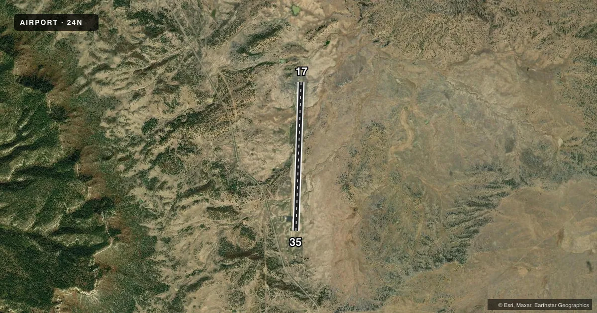
Runways & pattern
Full pagePattern entry · RWY 35
LEFT TRAFFICAirport sketch
Runways drawn to scale from FAA survey coordinates, rendered over satellite imagery. Not for navigation.
Approaches & charts
Services on the field
Fuel grades, oxygen, maintenance, ramp storage and lighting — as declared to the FAA by the airport operator.
Fuel & services
- Fuel
- Not available
Ramp & ground
- Transient storage
- Tie-down
- Wind indicator
- No
- Segmented circle
- Yes
Fuel & FBOs
Cheapest 100LL and Jet A on the field and nearby. Always confirm with the FBO before taxi.
Airport notes
Surface conditions, obstructions, local procedures, lighting outages and other notes published with each FAA cycle.
General notes
- RISING TERRAIN IN ALL DIRECTIONS.
- MAIN GATE LOCKED AT ALL TIMES; CTC AMGR TO ENTER/EXIT 505-215-5640.
- RWY 17 WIND SOCK LGTS OTS INDEFLY.
- WILDLIFE ON & INVOF AIRPORT.
- POWERLINE MARKED AND LIGHTED .4 NM WEST OF RY 17/35.
- FOR CD CTC DENVER ARTCC AT 303-651-4257.
- ACTVT ARPT BCN AND RAMP LTS - CTAF. RWY ONLY HAS RETROREFLECTORS.
Other notes
- CHAINS, CABLES OR ROPES NOT SUPPLIED.
VFR map & nearby airports
VFR sectional. Tap any ICAO chip to open that airport.
Key facts · 24N
Answer card- ICAO
- 24N
- Name
- JICARILLA APACHE NATION
- Location
- DULCE, NEW MEXICO
- Elevation
- 7,618 ft MSL
- Traffic pattern altitude
- 8,618 ft MSL (1,000 AGL)
- Control tower
- Non-towered (use CTAF)
- Total runways
- 1
- Longest runway
- 17/35 · 7,500 ft
- Published ILS approaches
- 0
- Published frequencies
- 1
- Magnetic variation
- 11°
- Current flight rules
- VFR
- Current wind
- 320° at 2 kt
- Favored runway now
- RWY 35
Jicarilla Apache Nation Airport (24N) sits near Dulce, New Mexico. The field elevation is 7,618 ft MSL. It has one runway. Runway 17/35 is 7,500 ft long with asphalt pavement. The airport is not towered. CTAF is 122.9.
No ILS approaches are published here. Pattern altitude is not published, so verify the current Chart Supplement before you fly. The airport sits in high terrain. Rising terrain exists in all directions. Wildlife is also reported on and near the airport, so plan your arrival and departure with that in mind.
Published remarks matter here. A marked and lighted powerline sits 0.4 NM west of runway 17/35. Runway 17 wind sock lights are out of service indefinitely. The runway uses retroreflectors only. Airport beacon and ramp lights are activated by CTAF. Clearance delivery is handled through Denver ARTCC at 303-651-4257. The main gate is locked at all times. Contact the manager at 505-215-5640 to enter or exit. No on-field FBOs are listed, so verify services with the airport operator or call the field directly before arrival.