METAR & TAF 1V0
1V0 does not publish a METAR.
Showing the nearest reporting station: KDRO (DURANGO-LA PLATA COUNTY) · 21.2 NM away. Conditions at 1V0 may differ.
METAR · KDRO
Observed 05:53Z
KDRO 270553Z AUTO 33005KT 10SM CLR 21/14 A3028 RMK AO2 SLP144 60000 T02060139 10239 20194 58007
- Wind
- 330° @ 5 kt
- Visibility
- 10 SM
- Temp / Dew
- 21°C / 14°C
- Altimeter
- 30.28 inHg
- Clouds
- CLR
- Density alt
- 8,307 ft
- Ceiling
- Unlimited
- Rules
- VFR
Airport info & contacts
Manager on record, flight service, ARTCC, attendance schedule and pattern altitude — published by the FAA and refreshed every 28 days.
Location
- From city
- 3 NM NE
- VFR sectional
- DENVER
- ARTCC
- ZDV · DENVER
- NOTAM facility
- ABQ (NOTAM-D)
Airport manager
- Name
- JESSI LITZ-ROWDEN
- Phone
- 505-618-0301
- Address
- 3501 ACCESS RD C, ALBUQUERQUE NM 87106
Flight service · Hours
- FSS ABQ
- ALBUQUERQUE1-800-WX-BRIEF
- Attendance
- Unattended
Frequencies
Tap any row to copy the frequency to your clipboard.
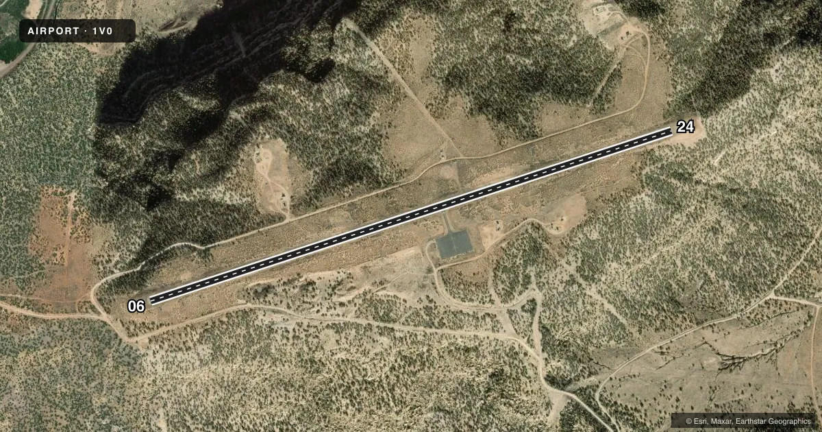
Runways & pattern
Full pagePattern entry · RWY 24
LEFT TRAFFICAirport sketch
Runways drawn to scale from FAA survey coordinates, rendered over satellite imagery. Not for navigation.
Approaches & charts
Services on the field
Fuel grades, oxygen, maintenance, ramp storage and lighting — as declared to the FAA by the airport operator.
Fuel & services
- Fuel
- Not available
- Oxygen (bottled)
- Not available
- Oxygen (bulk)
- Not available
- Airframe repair
- Not available
- Power plant repair
- Not available
Ramp & ground
- Transient storage
- Tie-down
- Landing fee
- No fee published
- Customs
- Not available
- Wind indicator
- Yes
- Segmented circle
- Yes
Fuel & FBOs
Cheapest 100LL and Jet A on the field and nearby. Always confirm with the FBO before taxi.
Airport notes
Surface conditions, obstructions, local procedures, lighting outages and other notes published with each FAA cycle.
General notes
- NO SNOW REMOVAL; PPR WHEN SNOW OR ICE ON RWY CALL 505-417-8368.
- GATE ALWAYS LOCKED; COMBINATION SET TO FIELD ELEVATION LISTED ON ENTRANCE SIGN.
- LIVESTOCK ON ARPT.
- ARPT CLSD AT NIGHT.
- ARPT LCTD ATOP MESA; STRONG DOWNDRAFTS ARE POSSIBLE ON SHORT FINAL TO RWY 06/24.
- FOR CD CTC DENVER ARTCC AT 303-651-4257.
Approach & departure obstructions
- 062 TO 3 FT BRUSH 50-200 FT FM THR; 6 FT POLE 70 FT FM THR, 65 FT RIGHT.
Other notes
- CABLES ONLY, CHAIN OR ROPE REQUIRED.
VFR map & nearby airports
VFR sectional. Tap any ICAO chip to open that airport.
Key facts · 1V0
Answer card- ICAO
- 1V0
- Name
- NAVAJO LAKE
- Location
- NAVAJO DAM, NEW MEXICO
- Elevation
- 6,478.2 ft MSL
- Traffic pattern altitude
- 7,478.2 ft MSL (1,000 AGL)
- Control tower
- Non-towered (use CTAF)
- Total runways
- 1
- Longest runway
- 06/24 · 5,022 ft
- Published ILS approaches
- 0
- Published frequencies
- 1
- Magnetic variation
- 12°
- Current flight rules
- VFR
- Current wind
- 330° at 5 kt
- Favored runway now
- RWY 24
Navajo Lake Airport sits in Navajo Dam, New Mexico. The field elevation is 6,478.2 ft MSL. It has one runway, 06/24, which is 5,022 ft long and paved. There is no control tower. CTAF is 122.9. No ILS approaches are published here.
The pattern altitude is not published. Use 1,000 ft AGL for light piston operations unless the current Chart Supplement says otherwise. That puts the standard pattern at about 7,478.2 ft MSL. The airport sits atop a mesa. Expect strong downdrafts on short final to runway 06/24. That matters here more than it would at a lower field. The airport is also closed at night. Livestock are on the airport. The gate is always locked. The combination is set to the field elevation shown on the entrance sign.
There are no on-field FBOs listed. Plan on self-sufficiency and verify current services with the airport operator before you go. Published remarks also note brush near the threshold of runway 06, plus a pole close to the right side of the approach path. There is no snow removal. Prior permission is required when snow or ice is on the runway. For clearance delivery, contact Denver ARTCC. This is a high-elevation mesa strip, so performance planning and a careful approach matter.