METAR & TAF 5V5
5V5 does not publish a METAR.
Showing the nearest reporting station: KFMN (FOUR CORNERS RGNL) · 22.8 NM away. Conditions at 5V5 may differ.
METAR · KFMN
Observed 05:53Z
KFMN 270553Z AUTO 09005KT 10SM CLR 26/14 A3019 RMK AO2 SLP146 60000 T02560139 10367 20250 51008 TSNO $
- Wind
- 090° @ 5 kt
- Visibility
- 10 SM
- Temp / Dew
- 26°C / 14°C
- Altimeter
- 30.19 inHg
- Clouds
- CLR
- Density alt
- 7,523 ft
- Ceiling
- Unlimited
- Rules
- VFR
Airport info & contacts
Manager on record, flight service, ARTCC, attendance schedule and pattern altitude — published by the FAA and refreshed every 28 days.
Location
- From city
- 5 NM S
- VFR sectional
- DENVER
- ARTCC
- ZDV · DENVER
- NOTAM facility
- ABQ (NOTAM-D)
Airport manager
- Name
- RAINEY CRAWFORD
- Phone
- (505) 728-2804
- Address
- NAVAJO DIV. OF TRANSPORTATION, PO BOX 4620, WINDOW ROCK AZ 86515
Flight service · Hours
- FSS ABQ
- ALBUQUERQUE1-800-WX-BRIEF
- Attendance
- Unattended
Frequencies
Tap any row to copy the frequency to your clipboard.
Runways & pattern
Full pagePattern entry · RWY 02
LEFT TRAFFICRunway end performance
| End | TORA | TODA | ASDA | LDA | VGSI | Approach lights | Obstruction |
|---|---|---|---|---|---|---|---|
| 02 | — | — | — | — | PAPI 2-box left(3°) | — | 50', pole, 1400' from thr, 125' R of cntrln, slope 24 |
| 20 | — | — | — | — | PAPI 2-box left(3°) | — | — |
Declared distances in feet. TORA = takeoff run available, TODA = takeoff distance, ASDA = accelerate-stop, LDA = landing distance.
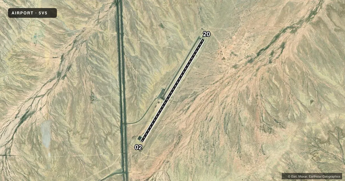
Airport sketch
Runways drawn to scale from FAA survey coordinates, rendered over satellite imagery. Not for navigation.
Approaches & charts
Services on the field
Fuel grades, oxygen, maintenance, ramp storage and lighting — as declared to the FAA by the airport operator.
Fuel & services
- Fuel
- Not available
Ramp & ground
- Transient storage
- Tie-down
- Landing fee
- No fee published
- Lighting schedule
- SEE RMK
- Beacon schedule
- SS-SR
- Beacon
- White / Green (civil land)(WG)
- Wind indicator
- Lighted
- Segmented circle
- Yes
Fuel & FBOs
Cheapest 100LL and Jet A on the field and nearby. Always confirm with the FBO before taxi.
Airport notes
Surface conditions, obstructions, local procedures, lighting outages and other notes published with each FAA cycle.
General notes
- FOR CD CTC DENVER ARTCC AT 303-651-4257.
- PARL TWY A: COND POOR; UNMKD; SFC CRACKS WITH GRASS & LOOSE AGGREGATE.
Lighting notes
- ACTVT MIRL RWY 02/20 - CTAF.
Runway surface & condition
- 02/20DITCH NW OF RWY ENTIRE LEN.
Approach & departure obstructions
- 0250 FT LGT POLES IN APCH AREA.
Other notes
- MANAGEREMERG & MAINT COORD - GARRETT SILVERSMITH 505-606-6357/505-371-8354/505-908-7961.
VFR map & nearby airports
VFR sectional. Tap any ICAO chip to open that airport.
Key facts · 5V5
Answer card- ICAO
- 5V5
- Name
- SHIPROCK AIRSTRIP
- Location
- SHIPROCK, NEW MEXICO
- Elevation
- 5,272.6 ft MSL
- Traffic pattern altitude
- 6,272.6 ft MSL (1,000 AGL)
- Control tower
- Non-towered (use CTAF)
- Total runways
- 1
- Longest runway
- 02/20 · 5,214 ft
- Published ILS approaches
- 0
- Published frequencies
- 1
- Magnetic variation
- 12°
- Current flight rules
- VFR
- Current wind
- 090° at 5 kt
- Favored runway now
- RWY 02
Shiprock Airstrip sits in Shiprock, New Mexico. Field elevation is 5,272.6 ft MSL. The airport has one runway. Runway 02/20 is 5,214 ft long with an asphalt surface. There is no control tower. CTAF is 122.9. No ILS approaches are published here.
Pattern altitude is not published. Use the standard 1,000 ft AGL pattern unless the current Chart Supplement or local procedures say otherwise. The field is in high desert country at a fairly high elevation. Expect density altitude to matter, especially on warm days. Runway 02 has 50-foot light poles in the approach area. There is also a ditch northwest of the runway along its full length. Taxiway A is reported in poor condition. It is unmarked. It has cracks, grass and loose aggregate.
Medium intensity runway lights for 02/20 are activated by CTAF. There are no on-field FBOs listed. For clearance delivery, contact Denver ARTCC at 303-651-4257. The emergency and maintenance coordinator is Garrett Silversmith at 505-606-6357, 505-371-8354, or 505-908-7961. Check the current FAA Chart Supplement for any published noise or curfew restrictions before flying in.