METAR & TAF 00C
00C does not publish a METAR.
Showing the nearest reporting station: KDRO (DURANGO-LA PLATA COUNTY) · 6.3 NM away. Conditions at 00C may differ.
METAR · KDRO
Observed 11:53Z
KDRO 271153Z AUTO 13004KT 10SM CLR 16/13 A3029 RMK AO2 SLP169 T01610128 10206 20156 53003
- Wind
- 130° @ 4 kt
- Visibility
- 10 SM
- Temp / Dew
- 16°C / 13°C
- Altimeter
- 30.29 inHg
- Clouds
- CLR
- Density alt
- 7,949 ft
- Ceiling
- Unlimited
- Rules
- VFR
Airport info & contacts
Manager on record, flight service, ARTCC, attendance schedule and pattern altitude — published by the FAA and refreshed every 28 days.
Location
- From city
- 4 NM S
- VFR sectional
- DENVER
- ARTCC
- ZDV · DENVER
- NOTAM facility
- DEN (NOTAM-D)
Airport manager
- Name
- DELVIN GREGG
- Phone
- 970-247-4632
- Address
- PO BOX 1797, DURANGO CO 81302
Flight service · Hours
- FSS DEN
- DENVER1-800-WX-BRIEF
- Attendance
- DALGT
Frequencies
Tap any row to copy the frequency to your clipboard.
Runways & pattern
Full pagePattern entry · RWY 19
LEFT TRAFFICRunway end performance
| End | TORA | TODA | ASDA | LDA | VGSI | Approach lights | Obstruction |
|---|---|---|---|---|---|---|---|
| 19 | — | — | — | — | — | — | 20', brush, 333' from thr, 98' R of cntrln, slope 5 |
Declared distances in feet. TORA = takeoff run available, TODA = takeoff distance, ASDA = accelerate-stop, LDA = landing distance.
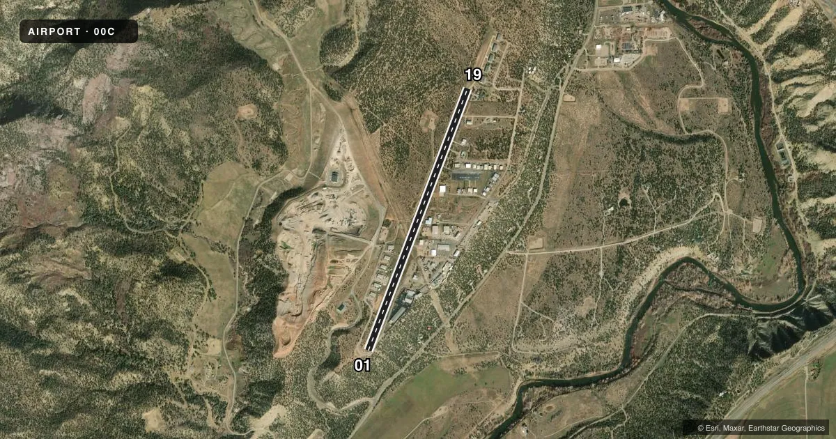
Airport sketch
Runways drawn to scale from FAA survey coordinates, rendered over satellite imagery. Not for navigation.
Approaches & charts
Services on the field
Fuel grades, oxygen, maintenance, ramp storage and lighting — as declared to the FAA by the airport operator.
Fuel & services
- Fuel
- 100LL
- Oxygen (bottled)
- Not available
- Oxygen (bulk)
- High pressure
- Airframe repair
- Major
- Power plant repair
- Major
- Other services
- AGRI,AMB,CARGO,CHTR,INSTR,RNTL,SURV
Ramp & ground
- Transient storage
- Tie-down
- Hangar
- Landing fee
- No fee published
- Lighting schedule
- SEE RMK
- Wind indicator
- Yes
- Segmented circle
- Yes
Fuel & FBOs
Cheapest 100LL and Jet A on the field and nearby. Always confirm with the FBO before taxi.
Airport notes
Surface conditions, obstructions, local procedures, lighting outages and other notes published with each FAA cycle.
General notes
- CTN: HEL HOSP OPS 2.4 NM NE.
- FOR CD CTC DENVER ARTCC AT 303-651-4257.
Lighting notes
- ACTVT MIRL RWY 01/19 - 122.9.
Runway surface & condition
- 01/19-1 TO - 2 FT DRAINAGE DITCHES 35 FT W & 30 FT E ALG CNTRLN; +4 FT FENCE 87 FT W ALG CNTRLN; +10 FT ROAD 105 FT W ALG CNTRLN.
- 01/19THR LGTS N END 162 FT FM PAVEMENT END.
Approach & departure obstructions
- 01+32 FT HNGR 1495 FT FM THR 100 FT R OF CNTRLN.
- 19+10 FT ROAD AT THR 25 L OF CNTRLN; +16 FT TREE 116 FT FM THR 90 FT R OF CNTRLN; +11 FT TREE 41 FT FM THR 78 FT R OF CNTRLN; +9 FT TREE 73 FT FM THR 74 L OF CNTRLN.
- 01200 FT DROPOFF 120 FT FM & PARALLEL THR; +15 FT TREES 1817 FT FM THR 105 FT L OF CNTRLN.
Other notes
- THIS AIRPORT HAS BEEN SURVEYED BY THE NATIONAL GEODETIC SURVEY.
VFR map & nearby airports
VFR sectional. Tap any ICAO chip to open that airport.
Key facts · 00C
Answer card- ICAO
- 00C
- Name
- ANIMAS AIR PARK
- Location
- DURANGO, COLORADO
- Elevation
- 6,684 ft MSL
- Traffic pattern altitude
- 7,684 ft MSL (1,000 AGL)
- Control tower
- Non-towered (use CTAF)
- Total runways
- 1
- Longest runway
- 01/19 · 5,010 ft
- Published ILS approaches
- 0
- Published frequencies
- 2
- Magnetic variation
- 12°
- Current flight rules
- VFR
- Current wind
- 130° at 4 kt
- Favored runway now
- RWY 19
Animas Air Park sits in Durango, Colorado at 6,684 ft MSL. It has one runway, 01/19, which is 5,010 ft long and paved. There is no control tower. CTAF and UNICOM are both 122.8. No ILS approaches are published here.
Pattern altitude is not published. Use the standard 1,000 ft AGL pattern unless the current Chart Supplement or local guidance says otherwise. Gregg Flying Service is on the field. It carries 100LL. Call (970) 247-4632 for current service details before you go.
This is a high-elevation airport, so performance planning matters. Expect the field to feel different than a lowland strip, especially on warm days. The published remarks also call out several obstructions near the runway. There is a hangar near the 01 end. The 19 end has roads and trees close to the threshold. Threshold lights are at the north end, 162 ft from the pavement end. Medium intensity runway lights on 01/19 are activated on 122.9. Clearance delivery is handled through Denver ARTCC at 303-651-4257. Helicopter hospital traffic is reported 2.4 NM northeast, so keep your scan sharp in the pattern and on departure.