METAR & TAF E91
E91 does not publish a METAR.
Showing the nearest reporting station: KRQE (WINDOW ROCK) · 36.9 NM away. Conditions at E91 may differ.
METAR · KRQE
Observed 08:53Z
KRQE 270853Z AUTO 00000KT 10SM CLR 18/14 A3029 RMK AO2 SLP120 T01780144 58002 $
- Wind
- 000° @ 0 kt
- Visibility
- 10 SM
- Temp / Dew
- 18°C / 14°C
- Altimeter
- 30.29 inHg
- Clouds
- CLR
- Density alt
- 6,783 ft
- Ceiling
- Unlimited
- Rules
- VFR
Airport info & contacts
Manager on record, flight service, ARTCC, attendance schedule and pattern altitude — published by the FAA and refreshed every 28 days.
Location
- From city
- 3 NM SW
- VFR sectional
- DENVER
- ARTCC
- ZDV · DENVER
- NOTAM facility
- PRC (NOTAM-D)
Airport manager
- Name
- KYRON HARDY
- Phone
- 505-371-8323
- Address
- P.O. BOX 4620, WINDOW ROCK AZ 86515
Flight service · Hours
- FSS PRC
- PRESCOTT1-800-WX-BRIEF
- Attendance
- Unattended
Frequencies
Tap any row to copy the frequency to your clipboard.
Runways & pattern
Full pagePattern entry · RWY 18
LEFT TRAFFICRunway end performance
| End | TORA | TODA | ASDA | LDA | VGSI | Approach lights | Obstruction |
|---|---|---|---|---|---|---|---|
| 36 | — | — | — | — | PAPI 2-box left | — | — |
Declared distances in feet. TORA = takeoff run available, TODA = takeoff distance, ASDA = accelerate-stop, LDA = landing distance.
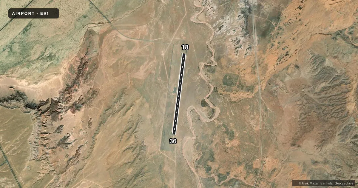
Airport sketch
Runways drawn to scale from FAA survey coordinates, rendered over satellite imagery. Not for navigation.
Approaches & charts
Services on the field
Fuel grades, oxygen, maintenance, ramp storage and lighting — as declared to the FAA by the airport operator.
Fuel & services
- Fuel
- Not available
- Other services
- AMB
Ramp & ground
- Transient storage
- Tie-down
- Lighting schedule
- SEE RMK
- Beacon schedule
- SS-SR
- Beacon
- Green(G)
- Wind indicator
- Lighted
- Segmented circle
- Yes
Fuel & FBOs
Cheapest 100LL and Jet A on the field and nearby. Always confirm with the FBO before taxi.
Airport notes
Surface conditions, obstructions, local procedures, lighting outages and other notes published with each FAA cycle.
General notes
- FOR CD CTC DENVER ARTCC AT 303-651-4257.
- PRKG APRON HAS LRG CRACKS & LOOSE AGGREGATE.
Lighting notes
- ACTVT PAPI RWY 36; MIRL RWY 18/36 - CTAF.
VFR map & nearby airports
VFR sectional. Tap any ICAO chip to open that airport.
Key facts · E91
Answer card- ICAO
- E91
- Name
- CHINLE MUNI
- Location
- CHINLE, ARIZONA
- Elevation
- 5,550 ft MSL
- Traffic pattern altitude
- 6,550 ft MSL (1,000 AGL)
- Control tower
- Non-towered (use CTAF)
- Total runways
- 1
- Longest runway
- 18/36 · 6,902 ft
- Published ILS approaches
- 0
- Published frequencies
- 1
- Magnetic variation
- 11°
- Current flight rules
- VFR
- Current wind
- 000° at 0 kt
- Favored runway now
- –
Chinle Muni is in Chinle, Arizona. The field elevation is 5,550 ft MSL. It has one runway, 18/36, which is 6,902 ft long. The airport is not towered. CTAF is 122.9.
No ILS approaches are published here. The pattern altitude is not published in the facts, so use the current Chart Supplement and standard local traffic procedures before you arrive. The runway lighting setup includes medium intensity runway lights on 18 and 36. Runway 36 also has a precision approach path indicator. That helps on night arrivals and on short final.
There are no on-field FBOs listed in the facts. Contact the airport operator directly or call the field on CTAF for current services before you go. The published remarks also note cracks and loose aggregate on the parking apron. Plan your taxi and parking with that in mind. For clearance delivery, contact Denver Air Route Traffic Control Center at 303-651-4257. This is a high-elevation airport in northern Arizona. Performance planning matters. Check density altitude, runway length and your takeoff numbers before departure.