METAR & TAF 0V7
0V7 does not publish a METAR.
Showing the nearest reporting station: KPGA (PAGE MUNI) · 60.0 NM away. Conditions at 0V7 may differ.
METAR · KPGA
Observed 18:53Z
KPGA 261853Z AUTO 10SM CLR 36/12 A3009 RMK AO2 SLP108 T03560122 $
- Wind
- Calm
- Visibility
- 10 SM
- Temp / Dew
- 36°C / 12°C
- Altimeter
- 30.09 inHg
- Clouds
- CLR
- Density alt
- 9,362 ft
- Ceiling
- Unlimited
- Rules
- VFR
Airport info & contacts
Manager on record, flight service, ARTCC, attendance schedule and pattern altitude — published by the FAA and refreshed every 28 days.
Location
- From city
- 2 NM SE
- VFR sectional
- DENVER
- ARTCC
- ZDV · DENVER
- NOTAM facility
- PRC (NOTAM-D)
Airport manager
- Name
- KURT CLAW
- Phone
- 928-697-8404
- Address
- PUBLIC WORKS DEPT, P.O. BOX 1490, KAYENTA AZ 86033
Flight service · Hours
- FSS PRC
- PRESCOTT1-800-WX-BRIEF
- Attendance
- Unattended
Frequencies
Tap any row to copy the frequency to your clipboard.
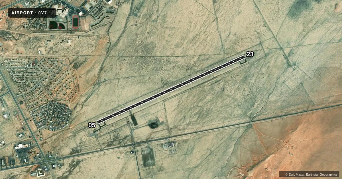
Runways & pattern
Full pagePattern entry · RWY 05
LEFT TRAFFICRunway end performance
| End | TORA | TODA | ASDA | LDA | VGSI | Approach lights | Obstruction |
|---|---|---|---|---|---|---|---|
| 05 | — | — | — | — | PAPI 2-box left(3°) | — | — |
| 23 | — | — | — | — | PAPI 2-box left(3°) | — | — |
Declared distances in feet. TORA = takeoff run available, TODA = takeoff distance, ASDA = accelerate-stop, LDA = landing distance.
Airport sketch
Runways drawn to scale from FAA survey coordinates, rendered over satellite imagery. Not for navigation.
Approaches & charts
Services on the field
Fuel grades, oxygen, maintenance, ramp storage and lighting — as declared to the FAA by the airport operator.
Fuel & services
- Fuel
- Not available
Ramp & ground
- Transient storage
- Tie-down
- Landing fee
- No fee published
- Customs
- Not available
- Lighting schedule
- SEE RMK
- Beacon schedule
- SS-SR
- Beacon
- White / Green (civil land)(WG)
- Wind indicator
- Yes
- Segmented circle
- Yes
Fuel & FBOs
Cheapest 100LL and Jet A on the field and nearby. Always confirm with the FBO before taxi.
Airport notes
Surface conditions, obstructions, local procedures, lighting outages and other notes published with each FAA cycle.
General notes
- NMRS RWY HOLD & TWY SIGNS INOP.
Lighting notes
- ACTVT PAPI RWY 05 & 23; MIRL RWY 05/23 - CTAF.
Approach & departure obstructions
- 05+3 FT BUSH 150 FT FM TH, 25 FT L OF CNTRLN.
Other notes
- ESTAB PRIOR 5/15/59.
- BRING OWN ROPES OR CHAINS.
VFR map & nearby airports
VFR sectional. Tap any ICAO chip to open that airport.
Key facts · 0V7
Answer card- ICAO
- 0V7
- Name
- KAYENTA
- Location
- KAYENTA, ARIZONA
- Elevation
- 5,687.5 ft MSL
- Traffic pattern altitude
- 6,687.5 ft MSL (1,000 AGL)
- Control tower
- Non-towered (use CTAF)
- Total runways
- 1
- Longest runway
- 05/23 · 7,101 ft
- Published ILS approaches
- 0
- Published frequencies
- 1
- Magnetic variation
- 13°
- Current flight rules
- VFR
- Current wind
- Calm / unavailable
- Favored runway now
- –
Kayenta Airport (0V7) sits in Kayenta, Arizona. The field elevation is 5,687.5 ft MSL. It has one runway. Runway 05/23 is 7,101 ft long and paved asphalt. There is no control tower. CTAF is 122.9.
No ILS approaches are published here. The pattern altitude is not published, so use the standard 1,000 ft AGL for light piston operations unless the current FAA Chart Supplement says otherwise. The airport sits at high elevation, so expect density altitude to matter on warm days. That affects takeoff roll, climb and go-around performance.
Published remarks say to bring your own ropes or chains. Several runway hold and taxiway signs are inoperative. The precision approach path indicators and medium intensity runway lights for runways 05 and 23 are activated on CTAF. There is also a small bush near the threshold of runway 05, 25 ft left of centerline and 150 ft from the threshold. No on-field FBOs are listed. Contact the airport operator directly or call the field on CTAF for current services before arrival. The airport manager is Jarvis Williams at 928-697-8451.