METAR & TAF U96
Current METAR
Observed 09:55Z
KU96 270955Z AUTO 36006KT 10SM CLR 29/13 A3004 RMK AO2 T02890126
- Wind
- 360° @ 6 kt
- Visibility
- 10 SM
- Temp / Dew
- 29°C / 13°C
- Altimeter
- 30.04 inHg
- Clouds
- CLR
- Density alt
- 6,981 ft
- Ceiling
- Unlimited
- Rules
- VFR
Airport info & contacts
Manager on record, flight service, ARTCC, attendance schedule and pattern altitude — published by the FAA and refreshed every 28 days.
Location
- From city
- 10 NM E
- VFR sectional
- DENVER
- ARTCC
- ZDV · DENVER
- NOTAM facility
- CDC (NOTAM-D)
Airport manager
- Name
- MARK MCDONALD
- Phone
- 435-485-0024
- Address
- 117 S MAIN, PO BOX 9, MONTICELLO UT 84535
Flight service · Hours
- FSS CDC
- CEDAR CITY1-800-WX-BRIEF
- Attendance
- ALL
Frequencies
Tap any row to copy the frequency to your clipboard.
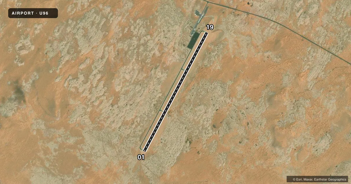
Runways & pattern
Full pagePattern entry · RWY 01
LEFT TRAFFICRunway end performance
| End | TORA | TODA | ASDA | LDA | VGSI | Approach lights | Obstruction |
|---|---|---|---|---|---|---|---|
| 01 | — | — | — | — | PAPI 2-box left(3°) | — | — |
| 19 | — | — | — | — | PAPI 2-box left(3°) | — | — |
Declared distances in feet. TORA = takeoff run available, TODA = takeoff distance, ASDA = accelerate-stop, LDA = landing distance.
Airport sketch
Runways drawn to scale from FAA survey coordinates, rendered over satellite imagery. Not for navigation.
Approaches & charts
Services on the field
Fuel grades, oxygen, maintenance, ramp storage and lighting — as declared to the FAA by the airport operator.
Fuel & services
- Fuel
- 100LLA
- Oxygen (bottled)
- Not available
- Oxygen (bulk)
- Not available
- Airframe repair
- Not available
- Power plant repair
- Not available
Ramp & ground
- Transient storage
- Tie-down
- Lighting schedule
- SEE RMK
- Beacon schedule
- SS-SR
- Beacon
- White / Green (civil land)(WG)
- Wind indicator
- Lighted
- Segmented circle
- Yes
Fuel & FBOs
Cheapest 100LL and Jet A on the field and nearby. Always confirm with the FBO before taxi.
Airport notes
Surface conditions, obstructions, local procedures, lighting outages and other notes published with each FAA cycle.
Lighting notes
- ACTVT REIL RWY 01 & 19; PAPI RWY 01 & 19; MIRL RWY 01/19 - CTAF.
Fuel notes
- 100LL24 HR SELF-SVC.
VFR map & nearby airports
VFR sectional. Tap any ICAO chip to open that airport.
Key facts · U96
Answer card- ICAO
- U96
- Name
- CAL BLACK MEML
- Location
- HALLS CROSSING, UTAH
- Elevation
- 4,394.6 ft MSL
- Traffic pattern altitude
- 5,394.6 ft MSL (1,000 AGL)
- Control tower
- Non-towered (use CTAF)
- Total runways
- 1
- Longest runway
- 01/19 · 5,700 ft
- Published ILS approaches
- 0
- Published frequencies
- 2
- Magnetic variation
- 13°
- Current flight rules
- VFR
- Current wind
- 360° at 6 kt
- Favored runway now
- RWY 01
Cal Black Meml Airport sits in Halls Crossing, Utah. The field elevation is 4,394.6 ft MSL. It has one runway. Runway 01/19 is 5,700 ft long with an asphalt surface. There is no control tower. CTAF and UNICOM are both 123.0.
No ILS approaches are published here. The runway lighting is pilot-controlled on the CTAF. Runway end identifier lights are installed on 01 and 19. PAPI is available on both ends. 100LL is available 24 hours by self-service. That helps if you are arriving outside normal fuel desk hours.
The published pattern altitude is not listed, so use standard traffic pattern planning unless the current FAA Chart Supplement says otherwise. For a light piston, that usually means 1,000 ft AGL. RoughRock Aviation is on the field. It carries AVGAS 100LL, JET A and MOGAS. Call them at (435) 485-0024 if you need current ramp or fuel availability details.
This is a high-elevation field, so performance planning matters. Check density altitude before departure, especially on warm days. If you are new to the area, verify the current Chart Supplement for any local remarks before you go.