METAR & TAF KHVE
Current METAR
Observed 15:35Z
KHVE 261535Z AUTO 00000KT 10SM CLR 32/10 A3014 RMK AO2
- Wind
- 000° @ 0 kt
- Visibility
- 10 SM
- Temp / Dew
- 32°C / 10°C
- Altimeter
- 30.14 inHg
- Clouds
- CLR
- Density alt
- 7,290 ft
- Ceiling
- Unlimited
- Rules
- VFR
Airport info & contacts
Manager on record, flight service, ARTCC, attendance schedule and pattern altitude — published by the FAA and refreshed every 28 days.
Location
- From city
- 3 NM N
- VFR sectional
- DENVER
- ARTCC
- ZLC · SALT LAKE CITY
- NOTAM facility
- HVE (NOTAM-D)
Airport manager
- Name
- UTAH DIVISION OF AERONAUTICS
- Phone
- 503-847-7176
- Address
- 135 N 2400 W, SALT LAKE CITY UT 84116
Flight service · Hours
- FSS CDC
- CEDAR CITY1-800-WX-BRIEF
- Attendance
- Unattended
Frequencies
Tap any row to copy the frequency to your clipboard.
Runways & pattern
Full pagePattern entry · RWY 09
LEFT TRAFFIC| Runway | Heading (°M) | Length | Surface | Traffic |
|---|---|---|---|---|
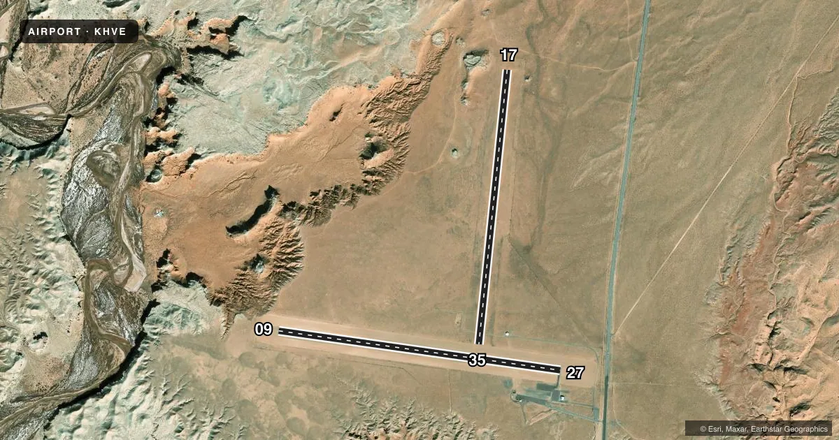
| 09/27 | 84° / 264° | 5,001 ft | ASPH | Standard L |
| 17/35 | 172° / 352° | 4,841 ft | DIRT | Standard L |
Runway end performance
| End | TORA | TODA | ASDA | LDA | VGSI | Approach lights | Obstruction |
|---|---|---|---|---|---|---|---|
| 09 | — | — | — | — | PAPI 4-box left(3°) | — | — |
| 27 | — | — | — | — | PAPI 4-box left(3°) | — | — |
Declared distances in feet. TORA = takeoff run available, TODA = takeoff distance, ASDA = accelerate-stop, LDA = landing distance.
Airport sketch
Runways drawn to scale from FAA survey coordinates, rendered over satellite imagery. Not for navigation.
Approaches & charts
Services on the field
Fuel grades, oxygen, maintenance, ramp storage and lighting — as declared to the FAA by the airport operator.
Fuel & services
- Fuel
- Not available
- Oxygen (bottled)
- Not available
- Oxygen (bulk)
- Not available
- Airframe repair
- Not available
- Power plant repair
- Not available
Ramp & ground
- Transient storage
- Tie-down
- Landing fee
- No fee published
- Lighting schedule
- SEE RMK
- Beacon schedule
- SS-SR
- Beacon
- White / Green (civil land)(WG)
- Wind indicator
- Yes
- Segmented circle
- No
Fuel & FBOs
Cheapest 100LL and Jet A on the field and nearby. Always confirm with the FBO before taxi.
Airport notes
Surface conditions, obstructions, local procedures, lighting outages and other notes published with each FAA cycle.
General notes
- FOR CD IF UNA TO CTC ON FSS FREQ, CTC SALT LAKE ARTCC AT 801-320-2568.
- RWY NOT PLOWED DRG WINTER MONTHS.
Lighting notes
- ACTVT PAPI RWY 09 & 27; MIRL RWY 09/27 - CTAF.
Other notes
- PRVDD RWY 17/35 IS RSTRD TO LNDG NORTH AND TKOF TO THE SOUTH ONLY.
- 17/35FIRST 1000 FT OF RWY 17 SOFT.
- 17/35UNUSBL S OF RWY 09/27; VEGETATION ON RWY.
VFR map & nearby airports
VFR sectional. Tap any ICAO chip to open that airport.
Key facts · KHVE
Answer card- ICAO
- KHVE
- Name
- HANKSVILLE
- Location
- HANKSVILLE, UTAH
- Elevation
- 4,453.6 ft MSL
- Traffic pattern altitude
- 5,453.6 ft MSL (1,000 AGL)
- Control tower
- Non-towered (use CTAF)
- Total runways
- 2
- Longest runway
- 09/27 · 5,001 ft
- Published ILS approaches
- 0
- Published frequencies
- 2
- Magnetic variation
- 14°
- Current flight rules
- VFR
- Current wind
- 000° at 0 kt
- Favored runway now
- –
Hanksville Airport sits in Hanksville, Utah. Field elevation is 4,453.6 ft MSL. The airport has two runways. The longest is runway 09/27 at 5,001 ft. Runway 17/35 is 4,841 ft and is dirt. There is no control tower. CTAF and UNICOM are both 122.8.
No ILS approaches are published here. Pattern altitude is not published, so a light piston pilot should plan on the standard 1,000 ft AGL unless the current Chart Supplement says otherwise. That puts the traffic pattern at 5,453.6 ft MSL by simple math. Verify the published pattern before you go.
The remarks matter here. Runway 17/35 is restricted to landing north and takeoff to the south only. The first 1,000 ft of runway 17 is soft. Vegetation makes runway 17/35 unusable south of runway 09/27. Winter operations can be limited because the runways are not plowed. For runway 09/27, the PAPI and medium intensity runway lights are activated on CTAF. No on-field FBOs are listed, so verify services with the airport operator or the FBO directly by phone before arrival. This is a high-elevation field in open country, so expect density altitude to matter on warm days.