METAR & TAF KCNY
Current METAR
Observed 08:53Z
KCNY 270853Z AUTO 22005KT CLR 26/15 A3007 RMK AO2 SLP106 T02610150 50001 $
- Wind
- 220° @ 5 kt
- Visibility
- —
- Temp / Dew
- 26°C / 15°C
- Altimeter
- 30.07 inHg
- Clouds
- CLR
- Density alt
- 6,812 ft
- Ceiling
- Unlimited
- Rules
- VFR
Airport info & contacts
Manager on record, flight service, ARTCC, attendance schedule and pattern altitude — published by the FAA and refreshed every 28 days.
Location
- From city
- 15 NM NW
- VFR sectional
- DENVER
- ARTCC
- ZDV · DENVER
- NOTAM facility
- CNY (NOTAM-D)
Airport manager
- Name
- STEVEN GLEASON
- Phone
- 435-259-4120
- Address
- 110 W. AVIATION WAY, MOAB UT 84532
Flight service · Hours
- FSS CDC
- CEDAR CITY1-800-WX-BRIEF
- Attendance
- MAR-OCT · 0800-1800
- NOV-FEB · 0900-1700
Frequencies
Tap any row to copy the frequency to your clipboard.
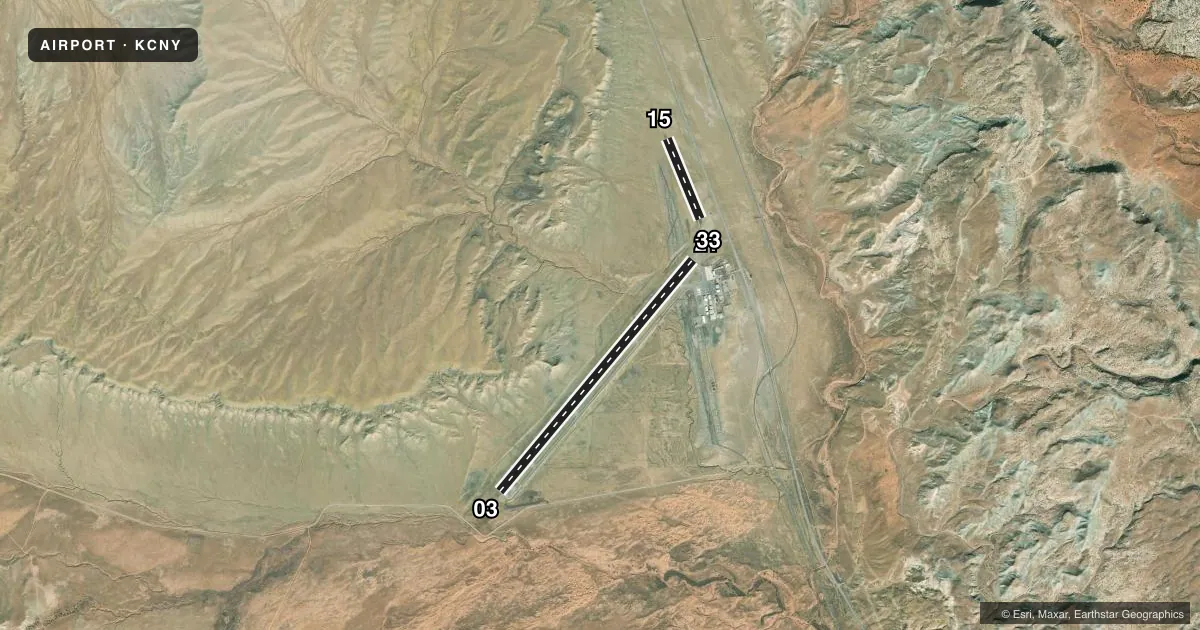
Runways & pattern
Full pagePattern entry · RWY 21
RIGHT TRAFFIC| Runway | Heading (°M) | Length | Surface | Traffic |
|---|---|---|---|---|
| 03/21Favored | 30° / 210° | 7,360 ft | ASPH | 21 R |
| 15/33 | 148° / 328° | 2,121 ft | GRAVEL | Standard L |
Runway end performance
| End | TORA | TODA | ASDA | LDA | VGSI | Approach lights | Obstruction |
|---|---|---|---|---|---|---|---|
| 03 | 7,101' | 7,361' | 7,101' | 7,101' | PAPI 4-box left(3.35°) | — | — |
| 21 | 7,361' | 7,361' | 7,361' | 7,101' | PAPI 4-box left(3°) | — | 36', pline, 912' from thr, 464' R of cntrln, slope 19 |
| 15 | 2,000' | 2,000' | 2,000' | 2,000' | — | — | — |
| 33 | 2,000' | 2,000' | 2,000' | 2,000' | — | — | — |
Declared distances in feet. TORA = takeoff run available, TODA = takeoff distance, ASDA = accelerate-stop, LDA = landing distance.
Airport sketch
Runways drawn to scale from FAA survey coordinates, rendered over satellite imagery. Not for navigation.
Approaches & charts
Services on the field
Fuel grades, oxygen, maintenance, ramp storage and lighting — as declared to the FAA by the airport operator.
Fuel & services
- Fuel
- 100LLA
- Oxygen (bulk)
- HIGH/LOW
- Airframe repair
- Minor
- Power plant repair
- Minor
- Other services
- CHTR,INSTR,RNTL
Ramp & ground
- Transient storage
- Tie-down
- Hangar
- Landing fee
- Yes
- Customs
- Not available
- Lighting schedule
- SEE RMK
- Beacon
- White / Green (civil land)(WG)
- Wind indicator
- Lighted
- Segmented circle
- Yes
Fuel & FBOs
Cheapest 100LL and Jet A on the field and nearby. Always confirm with the FBO before taxi.
Airport notes
Surface conditions, obstructions, local procedures, lighting outages and other notes published with each FAA cycle.
Lighting notes
- ACTVT REIL RWY 03 & 21; MIRL RWY 03/21 - CTAF. PAPI RWY 03 & 21 ON CONSLY DURG DALGT HRS; ACTVT SS-SR - CTAF.
Runway surface & condition
- 03/21PCR VALUE: 327/F/D/X/T
- 15/33RWY 15/33 NOT AVBL FOR PART 121/PART 380 OPS WITH SKED PAX CARRYING OPS MORE THAN 9 PAX SEATS AND NON-SKED PAX CARRYING OPS MORE THAN 30 PAX SEATS.
Approach & departure obstructions
- 21PAPI DOES NOT PROVD OBST CLNC BYD 2.9 NM FM RWY THLD.
VFR map & nearby airports
VFR sectional. Tap any ICAO chip to open that airport.
Key facts · KCNY
Answer card- ICAO
- KCNY
- Name
- CANYONLANDS RGNL
- Location
- MOAB, UTAH
- Elevation
- 4,579.2 ft MSL
- Traffic pattern altitude
- 5,579.2 ft MSL (1,000 AGL)
- Control tower
- Non-towered (use CTAF)
- Total runways
- 2
- Longest runway
- 03/21 · 7,360 ft
- Published ILS approaches
- 0
- Published frequencies
- 2
- Magnetic variation
- 10°
- Current flight rules
- VFR
- Current wind
- 220° at 5 kt
- Favored runway now
- RWY 21
Canyonlands Rgnl sits near Moab, Utah. Field elevation is 4,579.2 ft MSL. The airport has two runways. The longest is 03/21 at 7,360 ft. Runway 15/33 is 2,121 ft of gravel. There is no control tower. CTAF and UNICOM are both 122.8.
No ILS approaches are published here. Pattern altitude is not published, so use the standard 1,000 ft AGL for light piston operations unless current airport guidance says otherwise. Redtail Aviation is on the field. It carries 100LL and Jet A Prist. Call them at (435) 259-7421 for current service details.
The published remarks matter here. Runway 15/33 is not available for certain large passenger-carrying operations. Runway 03 and 21 have edge lights, runway end identifier lights and PAPI. The PAPI on 21 does not provide obstacle clearance beyond 2.9 NM from the threshold. The pavement classification number for 03/21 is 327/F/D/X/T.
This is a high-elevation desert airport. Expect density altitude to be a real factor, especially in warm weather. Review the current FAA Chart Supplement before departure for any changes to lighting, runway use, or local procedures.