METAR & TAF U34
U34 does not publish a METAR.
Showing the nearest reporting station: KCNY (CANYONLANDS RGNL) · 25.3 NM away. Conditions at U34 may differ.
METAR · KCNY
Observed 21:53Z
KCNY 262153Z AUTO 03004KT CLR 39/08 A2998 RMK AO2 LTG DSNT SE SLP072 T03940083 $
- Wind
- 030° @ 4 kt
- Visibility
- —
- Temp / Dew
- 39°C / 8°C
- Altimeter
- 29.98 inHg
- Clouds
- CLR
- Density alt
- 8,056 ft
- Ceiling
- Unlimited
- Rules
- VFR
Airport info & contacts
Manager on record, flight service, ARTCC, attendance schedule and pattern altitude — published by the FAA and refreshed every 28 days.
Location
- From city
- 4 NM SW
- VFR sectional
- DENVER
- ARTCC
- ZLC · SALT LAKE CITY
- NOTAM facility
- CDC (NOTAM-D)
Airport manager
- Name
- TYLER HUNT
- Phone
- 435-564-3448
- Address
- 460 E. MAIN ST., P.O. BOX 620, GREEN RIVER UT 84525
Flight service · Hours
- FSS CDC
- CEDAR CITY1-800-WX-BRIEF
- Attendance
- Unattended
Frequencies
Tap any row to copy the frequency to your clipboard.
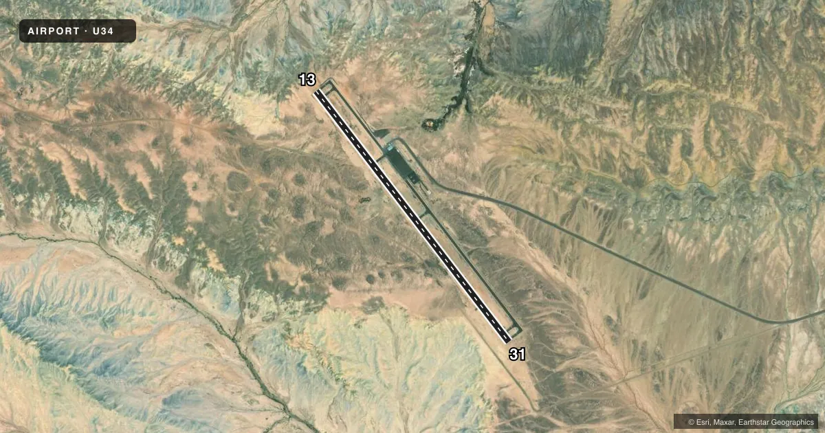
Runways & pattern
Full pagePattern entry · RWY 31
LEFT TRAFFICRunway end performance
| End | TORA | TODA | ASDA | LDA | VGSI | Approach lights | Obstruction |
|---|---|---|---|---|---|---|---|
| 13 | — | — | — | — | PAPI 2-box left(2.75°) | — | — |
| 31 | — | — | — | — | PAPI 2-box left(2.75°) | — | — |
Declared distances in feet. TORA = takeoff run available, TODA = takeoff distance, ASDA = accelerate-stop, LDA = landing distance.
Airport sketch
Runways drawn to scale from FAA survey coordinates, rendered over satellite imagery. Not for navigation.
Approaches & charts
Services on the field
Fuel grades, oxygen, maintenance, ramp storage and lighting — as declared to the FAA by the airport operator.
Fuel & services
- Fuel
- 100LL
- Oxygen (bottled)
- Not available
- Oxygen (bulk)
- Not available
- Airframe repair
- Not available
- Power plant repair
- Not available
Ramp & ground
- Transient storage
- Tie-down
- Landing fee
- No fee published
- Lighting schedule
- SEE RMK
- Beacon schedule
- SS-SR
- Beacon
- White / Green (civil land)(WG)
- Wind indicator
- Lighted
- Segmented circle
- Yes
Fuel & FBOs
Cheapest 100LL and Jet A on the field and nearby. Always confirm with the FBO before taxi.
Airport notes
Surface conditions, obstructions, local procedures, lighting outages and other notes published with each FAA cycle.
General notes
- FOR CD CTC SALT LAKE ARTCC AT 801-320-2568.
Lighting notes
- ACTVT REIL RWY 13 & 31; PAPI RWY 13 & 31; MIRL RWY 13/31 - CTAF.
Fuel notes
- 100LLFUEL 24 HR SELF SERVE.
Other notes
- DETERMINATION PENDING.
VFR map & nearby airports
VFR sectional. Tap any ICAO chip to open that airport.
Key facts · U34
Answer card- ICAO
- U34
- Name
- GREEN RIVER MUNI
- Location
- GREEN RIVER, UTAH
- Elevation
- 4,234.1 ft MSL
- Traffic pattern altitude
- 5,234.1 ft MSL (1,000 AGL)
- Control tower
- Non-towered (use CTAF)
- Total runways
- 1
- Longest runway
- 13/31 · 5,600 ft
- Published ILS approaches
- 0
- Published frequencies
- 2
- Magnetic variation
- 10°
- Current flight rules
- VFR
- Current wind
- 030° at 4 kt
- Favored runway now
- RWY 31
Green River Muni is in Green River, Utah. The field elevation is 4,234.1 ft MSL. It has one runway. Runway 13/31 is 5,600 ft long with asphalt pavement. This is an untowered field, so use CTAF 122.8 for traffic calls. Use UNICOM 122.8 for local coordination.
No ILS approaches are published here. Runway 13 and Runway 31 have REIL lighting and PAPI. The runway also has medium intensity runway lighting. Fuel is available 24 hours through self-service 100LL. There are no on-field FBOs listed in the facts, so verify services with the airport operator or call the field directly before arrival.
Pattern altitude is not published in the facts block. Use the current FAA Chart Supplement before flight for the correct traffic pattern altitude and any operational notes. The published remarks also say clearance delivery is handled through Salt Lake ARTCC at 801-320-2568. For a first-time arrival, the main things to plan for are the high field elevation, the single runway layout and the lack of tower service. Check the current Chart Supplement for any additional local procedures before you go.