METAR & TAF KPUC
Current METAR
Observed 09:53Z
KPUC 270953Z AUTO 07005KT 10SM CLR 25/12 A3020 RMK AO2 SLP090 T02500117 $
- Wind
- 070° @ 5 kt
- Visibility
- 10 SM
- Temp / Dew
- 25°C / 12°C
- Altimeter
- 30.20 inHg
- Clouds
- CLR
- Density alt
- 8,240 ft
- Ceiling
- Unlimited
- Rules
- VFR
Airport info & contacts
Manager on record, flight service, ARTCC, attendance schedule and pattern altitude — published by the FAA and refreshed every 28 days.
Location
- From city
- 3 NM E
- VFR sectional
- DENVER
- ARTCC
- ZLC · SALT LAKE CITY
- NOTAM facility
- PUC (NOTAM-D)
Airport manager
- Name
- DOUG BULLOCK
- Phone
- 205-910-7989
- Address
- 3095 AIRPORT ROAD, 3095 EAST AIRPORT ROAD, PRICE UT 84501
Flight service · Hours
- FSS CDC
- CEDAR CITY1-800-WX-BRIEF
- Attendance
- APRIL-OCT · 0800-1800
- NOV-MAR · MON-SAT · 0900-1700
Frequencies
Tap any row to copy the frequency to your clipboard.
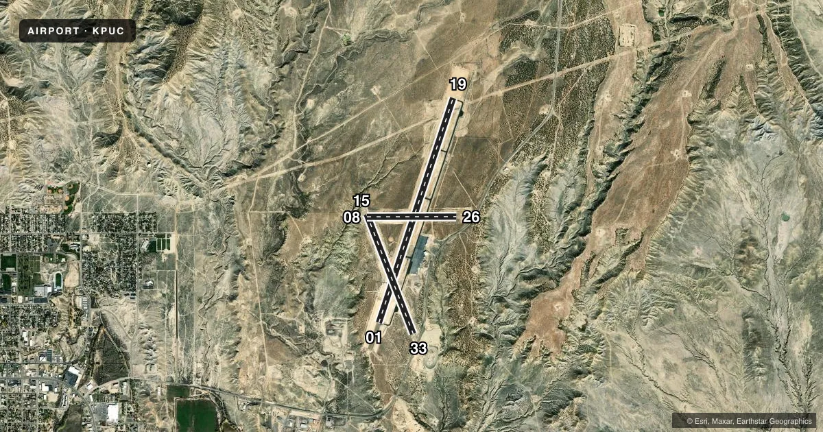
Runways & pattern
Full pagePattern entry · RWY 08
LEFT TRAFFIC| Runway | Heading (°M) | Length | Surface | Traffic |
|---|---|---|---|---|
| 01/19 | 7° / 187° | 8,316 ft | ASPH | Standard L |
| 15/33 | 147° / 327° | 4,513 ft | ASPH | Standard L |
| 08/26Favored | 79° / 259° | 3,151 ft | ASPH | Standard L |
Runway end performance
| End | TORA | TODA | ASDA | LDA | VGSI | Approach lights | Obstruction |
|---|---|---|---|---|---|---|---|
| 01 | — | — | — | — | PAPI 4-box left(3°) | MALSF | — |
| 19 | — | — | — | — | PAPI 2-box left(4°) | — | — |
| 33 | — | — | — | — | — | — | road, slope 20 |
| 08 | — | — | — | — | PAPI 2-box left(3°) | — | — |
| 26 | — | — | — | — | PAPI 2-box left(3°) | — | road, slope 18 |
Declared distances in feet. TORA = takeoff run available, TODA = takeoff distance, ASDA = accelerate-stop, LDA = landing distance.
Airport sketch
Runways drawn to scale from FAA survey coordinates, rendered over satellite imagery. Not for navigation.
Approaches & charts
ILS · 1
Services on the field
Fuel grades, oxygen, maintenance, ramp storage and lighting — as declared to the FAA by the airport operator.
Fuel & services
- Fuel
- 100LLA
- Oxygen (bottled)
- Not available
- Oxygen (bulk)
- Not available
- Airframe repair
- Minor
- Power plant repair
- Minor
- Other services
- AFRT,INSTR
Ramp & ground
- Transient storage
- Tie-down
- Hangar
- Landing fee
- Yes
- Customs
- Not available
- Lighting schedule
- SEE RMK
- Beacon schedule
- SS-SR
- Beacon
- White / Green (civil land)(WG)
- Wind indicator
- Yes
- Segmented circle
- No
Fuel & FBOs
Cheapest 100LL and Jet A on the field and nearby. Always confirm with the FBO before taxi.
Airport notes
Surface conditions, obstructions, local procedures, lighting outages and other notes published with each FAA cycle.
General notes
- FOR CD IF UNA TO CTC ON FSS FREQ, CTC SALT LAKE ARTCC AT 801-320-2568.
- RWY 15, 20 FT DROP OFF, 200 FT FM THLD.
- RWY 08, 60 FT DROP OFF, 520 FT FM RWY END.
Lighting notes
- ACTVT MALSF RWY 01; REIL RWY 19, 08 & 26; PAPI RWY 01 & 19, 08 & 26; HIRL RWY 01/19; MIRL RWY 15/33 - CTAF.
Fuel notes
- 100LL24 HR SELF SVC FUEL AVBL WITH CREDIT CARD.
Approach & departure obstructions
- 19PAPI UNUSBL BYD 3 NM DUE TO TRRN; BYD 9 DEGS RIGHT OF CNTRLN.
- 19HIGH VOLTAGE TRANS LINE ON EXTDD CNTRLN.
Other notes
- > 25K LBS $200 RAMP FEE. LNDG FEE WAIVED WITH MNM FUEL PURCHASE.
VFR map & nearby airports
VFR sectional. Tap any ICAO chip to open that airport.
Key facts · KPUC
Answer card- ICAO
- KPUC
- Name
- CARBON COUNTY RGNL/BUCK DAVIS FLD
- Location
- PRICE, UTAH
- Elevation
- 5,957.6 ft MSL
- Traffic pattern altitude
- 6,957.6 ft MSL (1,000 AGL)
- Control tower
- Non-towered (use CTAF)
- Total runways
- 3
- Longest runway
- 01/19 · 8,316 ft
- Published ILS approaches
- 1
- Published frequencies
- 2
- Magnetic variation
- 11°
- Current flight rules
- VFR
- Current wind
- 070° at 5 kt
- Favored runway now
- RWY 08
Carbon County Rgnl/Buck Davis Fld sits in Price, Utah. Field elevation is 5,957.6 ft MSL. The airport has three asphalt runways. The longest is runway 01/19 at 8,316 ft. There is no control tower. CTAF and UNICOM are both 122.8. Pattern altitude is not published, so plan on the standard 1,000 ft AGL unless the current Chart Supplement says otherwise.
KPUC has one ILS approach to runway 01. That is the main precision option here. Aggie Aviation Services is on the field. It carries 100LL, Jet A and Jet A Prist. Twenty-four hour self-serve 100LL is available with a credit card. The published remarks also note a high voltage transmission line on the extended centerline for runway 19. Runway 15 has a 20 ft drop-off 200 ft from the threshold. Runway 08 has a 60 ft drop-off 520 ft from the runway end.
This is a high-elevation airport, so performance planning matters. Density altitude can climb fast in warm weather. The field also has runway lighting details that matter after dark. Runway 01 uses MALSF lighting. Runway 01/19 has high intensity lights. Runway 15/33 has medium intensity lights. Check the current Chart Supplement for any noise or curfew restrictions before flying in. If you need clearance delivery and cannot reach Flight Service, contact Salt Lake ARTCC at 801-320-2568.