METAR & TAF 41U
Current METAR
Observed 07:35Z
K41U 270735Z AUTO 00000KT 10SM CLR 27/10 A3018 RMK AO1 T02650096
- Wind
- 000° @ 0 kt
- Visibility
- 10 SM
- Temp / Dew
- 27°C / 10°C
- Altimeter
- 30.18 inHg
- Clouds
- CLR
- Density alt
- 7,957 ft
- Ceiling
- Unlimited
- Rules
- VFR
Airport info & contacts
Manager on record, flight service, ARTCC, attendance schedule and pattern altitude — published by the FAA and refreshed every 28 days.
Location
- From city
- 4 NM NE
- VFR sectional
- LAS VEGAS
- ARTCC
- ZLC · SALT LAKE CITY
- NOTAM facility
- CDC (NOTAM-D)
Airport manager
- Name
- JASON BROWN
- Phone
- 435-421-4908
- Address
- 50 S MAIN ST #1, MANTI UT 84642
Flight service · Hours
- FSS CDC
- CEDAR CITY1-800-WX-BRIEF
- Attendance
- Unattended
Frequencies
Tap any row to copy the frequency to your clipboard.
Runways & pattern
Full pagePattern entry · RWY 03
LEFT TRAFFICRunway end performance
| End | TORA | TODA | ASDA | LDA | VGSI | Approach lights | Obstruction |
|---|---|---|---|---|---|---|---|
| 03 | — | — | — | — | PAPI 2-box left(3°) | — | — |
| 21 | — | — | — | — | PAPI 2-box left(3°) | — | 49', pline, 921' from thr, 113' R of cntrln, slope 14 |
Declared distances in feet. TORA = takeoff run available, TODA = takeoff distance, ASDA = accelerate-stop, LDA = landing distance.
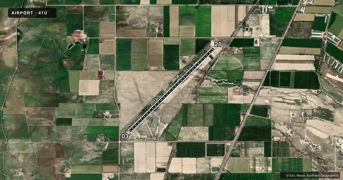
Airport sketch
Runways drawn to scale from FAA survey coordinates, rendered over satellite imagery. Not for navigation.
Approaches & charts
Services on the field
Fuel grades, oxygen, maintenance, ramp storage and lighting — as declared to the FAA by the airport operator.
Fuel & services
- Fuel
- 100LLA
- Oxygen (bottled)
- Not available
- Oxygen (bulk)
- Not available
- Airframe repair
- Minor
- Power plant repair
- Minor
- Other services
- INSTR
Ramp & ground
- Transient storage
- Tie-down
- Landing fee
- No fee published
- Customs
- Not available
- Lighting schedule
- SEE RMK
- Beacon schedule
- SS-SR
- Beacon
- White / Green (civil land)(WG)
- Wind indicator
- Lighted
- Segmented circle
- Yes
Fuel & FBOs
Cheapest 100LL and Jet A on the field and nearby. Always confirm with the FBO before taxi.
Airport notes
Surface conditions, obstructions, local procedures, lighting outages and other notes published with each FAA cycle.
General notes
- FOR CD CTC SALT LAKE ARTCC AT 801-320-2568.
Lighting notes
- ACTVT REIL RWY 03 & 21; PAPI RWY 03 & 21; MIRL RWY 03/21 - CTAF.
Fuel notes
- A100LL & JET A 24 HR, SELF SERVE.
Other notes
- MANAGERCITY/AMGR.
- MANAGEROTR CTC: SHAUN.KJAR@EPHRAIMCITY.ORG
VFR map & nearby airports
VFR sectional. Tap any ICAO chip to open that airport.
Key facts · 41U
Answer card- ICAO
- 41U
- Name
- SANPETE COUNTY RGNL
- Location
- MANTI, UTAH
- Elevation
- 5,515.8 ft MSL
- Traffic pattern altitude
- 6,515.8 ft MSL (1,000 AGL)
- Control tower
- Non-towered (use CTAF)
- Total runways
- 1
- Longest runway
- 03/21 · 5,021 ft
- Published ILS approaches
- 0
- Published frequencies
- 2
- Magnetic variation
- 11°
- Current flight rules
- VFR
- Current wind
- 000° at 0 kt
- Favored runway now
- –
Sanpete County Rgnl Airport (41U) sits in Manti, Utah. Field elevation is 5,515.8 ft MSL. The airport has one runway. Runway 03/21 is 5,021 ft long with asphalt pavement. There is no control tower. CTAF and UNICOM are both 122.8. No ILS approaches are published here.
Pattern altitude is not published. Use 1,000 ft AGL for light piston operations unless the current Chart Supplement says otherwise. At this elevation, expect performance to be affected by density altitude, especially on warm days. The runway lighting is pilot-controlled on CTAF. Runway end identifier lights are installed on 03 and 21. Precision approach path indicators are also installed on both ends, which helps on night or marginal VFR arrivals.
No on-field FBOs are listed. Fuel is available 24 hours through self-service. The published remarks also note that clearance delivery is handled through Salt Lake ARTCC at 801-320-2568. The airport manager is the city airport manager. For any current noise, operating, or field-use details that are not listed here, check the current FAA Chart Supplement or contact the airport operator directly before departure.