METAR & TAF KBDG
Current METAR
Observed 09:15Z
KBDG 270915Z AUTO 33003KT 10SM OVC130 22/15 A3019 RMK AO2 T02240147
- Wind
- 330° @ 3 kt
- Visibility
- 10 SM
- Temp / Dew
- 22°C / 15°C
- Altimeter
- 30.19 inHg
- Clouds
- OVC
- Density alt
- 7,781 ft
- Ceiling
- 13,000 ft AGL
- Rules
- VFR
Airport info & contacts
Manager on record, flight service, ARTCC, attendance schedule and pattern altitude — published by the FAA and refreshed every 28 days.
Location
- From city
- 3 NM S
- VFR sectional
- DENVER
- ARTCC
- ZDV · DENVER
- NOTAM facility
- CDC (NOTAM-D)
Airport manager
- Name
- TAYLOR FRANCOM
- Phone
- 435-678-2791
- Address
- 50 WEST 100 SOUTH, BLANDING UT 84511
Flight service · Hours
- FSS CDC
- CEDAR CITY1-800-WX-BRIEF
- Attendance
- ALL
Frequencies
Tap any row to copy the frequency to your clipboard.
Runways & pattern
Full pagePattern entry · RWY 35
LEFT TRAFFICRunway end performance
| End | TORA | TODA | ASDA | LDA | VGSI | Approach lights | Obstruction |
|---|---|---|---|---|---|---|---|
| 17 | — | — | — | — | PAPI 2-box left(3°) | — | — |
| 35 | — | — | — | — | PAPI 2-box left(3°) | — | 15', road, 620' from thr, 0' R of cntrln, slope 28 |
Declared distances in feet. TORA = takeoff run available, TODA = takeoff distance, ASDA = accelerate-stop, LDA = landing distance.
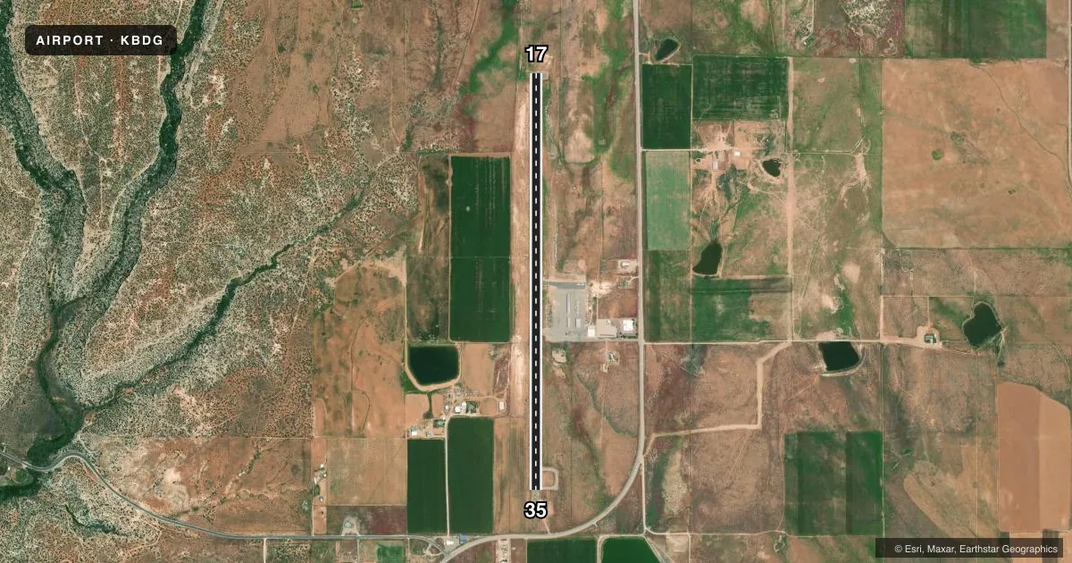
Airport sketch
Runways drawn to scale from FAA survey coordinates, rendered over satellite imagery. Not for navigation.
Approaches & charts
Services on the field
Fuel grades, oxygen, maintenance, ramp storage and lighting — as declared to the FAA by the airport operator.
Fuel & services
- Fuel
- 100LLA
- Airframe repair
- Not available
- Power plant repair
- Not available
- Other services
- AMB
Ramp & ground
- Transient storage
- Tie-down
- Landing fee
- No fee published
- Customs
- Not available
- Lighting schedule
- SEE RMK
- Beacon schedule
- SS-SR
- Beacon
- White / Green (civil land)(WG)
- Wind indicator
- Lighted
- Segmented circle
- Yes
Fuel & FBOs
Cheapest 100LL and Jet A on the field and nearby. Always confirm with the FBO before taxi.
Airport notes
Surface conditions, obstructions, local procedures, lighting outages and other notes published with each FAA cycle.
General notes
- WILDLIFE ON AND INVOF ARPT.
- FOR CD CTC DENVER ARTCC AT 303-651-4257.
Lighting notes
- ACTVT MIRL RWY 17/35, REIL - CTAF. PAPI RWY 17 & 35 OPER CONSLY.
Fuel notes
- 100LL24 HR FULL & SELF-SVC. CALL-IN & RAMP SVC FEE WAIVED WITH MIN FUEL PURCHASE.
Approach & departure obstructions
- 17RWY MKGS FADED.
- 35RWY MKGS FADED.
Other notes
- MANAGERDIR COMM. DEV/ARPT MGR. 435-678-2791.
- MANAGERFBO/ARPT ATTENDANT.
VFR map & nearby airports
VFR sectional. Tap any ICAO chip to open that airport.
Key facts · KBDG
Answer card- ICAO
- KBDG
- Name
- BLANDING MUNI
- Location
- BLANDING, UTAH
- Elevation
- 5,867.8 ft MSL
- Traffic pattern altitude
- 6,867.8 ft MSL (1,000 AGL)
- Control tower
- Non-towered (use CTAF)
- Total runways
- 1
- Longest runway
- 17/35 · 5,781 ft
- Published ILS approaches
- 0
- Published frequencies
- 2
- Magnetic variation
- 12°
- Current flight rules
- VFR
- Current wind
- 330° at 3 kt
- Favored runway now
- RWY 35
Blanding Muni sits in Blanding, Utah. The field elevation is 5,867.8 ft MSL. It has one runway, 17/35, which is 5,781 ft long. There is no control tower. CTAF and UNICOM are both 122.8. No ILS approaches are published here.
Pattern altitude is not published. Use the standard 1,000 ft AGL for light piston traffic unless the current FAA Chart Supplement says otherwise. At this elevation, performance planning matters. Expect high-density-altitude effects on takeoff and climb, especially on warm days. Wildlife is also present on and near the airport. Keep a sharp scan on taxi, takeoff and landing.
Freedom Fuels is on the field. It carries 100LL and Jet A. The published remarks say 100LL is available 24 hours as full service and self-service. They also note that call-in and ramp service fees are waived with a minimum fuel purchase. Runway lights are medium intensity on 17/35. REILs are controlled by CTAF. PAPI on both runway ends operate continuously. The runway markings on 17 and 35 are faded, so brief that into your landing plan.