METAR & TAF 8V6
8V6 does not publish a METAR.
Showing the nearest reporting station: KBDG (BLANDING MUNI) · 30.3 NM away. Conditions at 8V6 may differ.
METAR · KBDG
Observed 10:35Z
KBDG 271035Z AUTO 36004KT 10SM OVC170 21/16 A3019 RMK AO2 T02130157
- Wind
- 360° @ 4 kt
- Visibility
- 10 SM
- Temp / Dew
- 21°C / 16°C
- Altimeter
- 30.19 inHg
- Clouds
- OVC
- Density alt
- 9,034 ft
- Ceiling
- 17,000 ft AGL
- Rules
- VFR
Airport info & contacts
Manager on record, flight service, ARTCC, attendance schedule and pattern altitude — published by the FAA and refreshed every 28 days.
Location
- From city
- 1 NM E
- VFR sectional
- DENVER
- Pattern altitude
- 725 ft AGL · 7,700 ft MSL
- ARTCC
- ZDV · DENVER
- NOTAM facility
- DEN (NOTAM-D)
Airport manager
- Name
- R A ANDERSON
- Phone
- 970-677-2282
- Address
- BOX 86, DOVE CREEK CO 81324
Flight service · Hours
- FSS DEN
- DENVER1-800-WX-BRIEF
- Attendance
- Unattended
Frequencies
Tap any row to copy the frequency to your clipboard.
Runways & pattern
Full pagePattern entry · RWY 01
LEFT TRAFFICRunway end performance
| End | TORA | TODA | ASDA | LDA | VGSI | Approach lights | Obstruction |
|---|---|---|---|---|---|---|---|
| 01 | — | — | — | — | — | — | 11', road, 150' from thr, 0' R of cntrln, slope 13 |
| 19 | — | — | — | — | — | — | 19', road, 51' from thr, 0' R of cntrln, slope 2 |
Declared distances in feet. TORA = takeoff run available, TODA = takeoff distance, ASDA = accelerate-stop, LDA = landing distance.
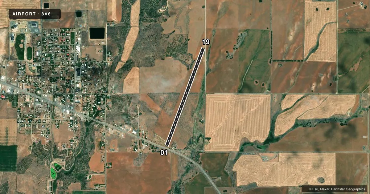
Airport sketch
Runways drawn to scale from FAA survey coordinates, rendered over satellite imagery. Not for navigation.
Approaches & charts
Services on the field
Fuel grades, oxygen, maintenance, ramp storage and lighting — as declared to the FAA by the airport operator.
Fuel & services
- Fuel
- Not available
- Oxygen (bottled)
- Not available
- Oxygen (bulk)
- Not available
Ramp & ground
- Transient storage
- Tie-down
- Landing fee
- No fee published
- Wind indicator
- Yes
- Segmented circle
- No
Fuel & FBOs
Cheapest 100LL and Jet A on the field and nearby. Always confirm with the FBO before taxi.
Airport notes
Surface conditions, obstructions, local procedures, lighting outages and other notes published with each FAA cycle.
General notes
- ARPT CLSD WHEN SNOW COVERED.
- VEHICLES ON ARPT.
- FOR CD CTC DENVER ARTCC AT 303-651-4257.
Runway surface & condition
- 01/19SOFT WHEN WET; -3FT DITCH ALONG BOTH SIDES; +4 FT BUSHES VARIOUS LOCATIONS 15 FT FM RWY EDGE.
Approach & departure obstructions
- 01+4 FT FENCE 0 FT FM & PARRALLEL TO THR; +15 FT ROAD 80 FT FM & PARALLEL TO THR; +30 FT TREES 189 FT FM THR; APCH RATION 0:1.
- 19+12 FT GND 258 FT R OF CNTRLN PARALLEL TO EXTDD CNTRLN FIRST 500 FT.
Other notes
- EXISTED PRIOR TO 1959.
- TPA 7700 MSL.
- MANAGERASSISTANCE BTN 0800-1200 - SHERIFFS DEPT 970-677-2257.
- 01/19RODENT HOLES THROUGHOUT.
VFR map & nearby airports
VFR sectional. Tap any ICAO chip to open that airport.
Key facts · 8V6
Answer card- ICAO
- 8V6
- Name
- DOVE CREEK
- Location
- DOVE CREEK, COLORADO
- Elevation
- 6,975 ft MSL
- Traffic pattern altitude
- 7,700 ft MSL (725 AGL)
- Control tower
- Non-towered (use CTAF)
- Total runways
- 1
- Longest runway
- 01/19 · 4,200 ft
- Published ILS approaches
- 0
- Published frequencies
- 1
- Magnetic variation
- 13°
- Current flight rules
- VFR
- Current wind
- 360° at 4 kt
- Favored runway now
- RWY 01
Dove Creek Airport sits in Dove Creek, Colorado. The field elevation is 6,975 ft MSL. It has one runway, 01/19, which is 4,200 ft long and dirt. There is no control tower. CTAF is 122.9. No ILS approaches are published here.
The traffic pattern altitude is 7,700 ft MSL. That is 725 ft AGL. The runway headings are magnetic. Runway 01 is 21°. Runway 19 is 201°.
This is a high-elevation field, so performance planning matters. The runway is also reported closed when snow covered. Published remarks say the surface can be soft when wet. Vehicles are present on the airport. There are also rodent holes in the runway surface, so expect a rougher-than-normal strip and use caution on rollout and taxi.
There are no on-field FBOs listed in the facts. Check with the airport operator or the FBO directly by phone before arrival for current services. For clearance delivery, contact Denver ARTCC at 303-651-4257. First-time pilots should also note the obstruction environment near runway 01 and 19. The published remarks call out a fence, a road, trees, a ditch, bushes and a ground obstruction near the runway. That makes a careful preflight and a stabilized approach important here.