METAR & TAF KPGA
Current METAR
Observed 11:53Z
KPGA 271153Z AUTO 00000KT 10SM CLR 27/11 A3007 RMK AO2 SLP105 T02670111 10306 20267 53002 $
- Wind
- 000° @ 0 kt
- Visibility
- 10 SM
- Temp / Dew
- 27°C / 11°C
- Altimeter
- 30.07 inHg
- Clouds
- CLR
- Density alt
- 6,607 ft
- Ceiling
- Unlimited
- Rules
- VFR
Airport info & contacts
Manager on record, flight service, ARTCC, attendance schedule and pattern altitude — published by the FAA and refreshed every 28 days.
Location
- From city
- 1 NM E
- VFR sectional
- LAS VEGAS
- ARTCC
- ZDV · DENVER
- NOTAM facility
- PGA (NOTAM-D)
Airport manager
- Name
- LORE DAVIS-MCCLUSKEY
- Phone
- 928-645-4240
- Address
- PO BOX 1180, 697 VISTA AVENUE, PAGE AZ 86040
Flight service · Hours
- FSS PRC
- PRESCOTT1-800-WX-BRIEF
- Attendance
- DALGT
Frequencies
Tap any row to copy the frequency to your clipboard.
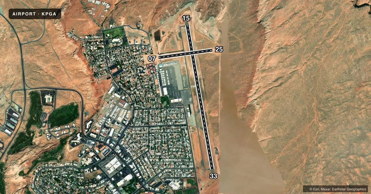
Runways & pattern
Full pagePattern entry · RWY 15
LEFT TRAFFIC| Runway | Heading (°M) | Length | Surface | Traffic |
|---|---|---|---|---|
| 15/33 | 156° / 336° | 5,950 ft | ASPH | 33 R |
| 07/25 | 68° / 248° | 2,201 ft | ASPH | 25 R |
Runway end performance
| End | TORA | TODA | ASDA | LDA | VGSI | Approach lights | Obstruction |
|---|---|---|---|---|---|---|---|
| 15 | 5,950' | 5,950' | 5,950' | 5,950' | VASI 4-box left(3°) | — | — |
| 33 | 5,950' | 5,950' | 5,950' | 5,950' | VASI 4-box left(3°) | — | — |
| 07 | 2,201' | 2,201' | 2,201' | 1,613' | — | — | — |
| 25 | 2,201' | 2,201' | 2,201' | 2,201' | — | — | — |
Declared distances in feet. TORA = takeoff run available, TODA = takeoff distance, ASDA = accelerate-stop, LDA = landing distance.
Airport sketch
Runways drawn to scale from FAA survey coordinates, rendered over satellite imagery. Not for navigation.
Approaches & charts
Services on the field
Fuel grades, oxygen, maintenance, ramp storage and lighting — as declared to the FAA by the airport operator.
Fuel & services
- Fuel
- 100LLA
- Oxygen (bottled)
- HIGH/LOW
- Oxygen (bulk)
- High pressure
- Airframe repair
- Major
- Power plant repair
- Major
- Other services
- AFRT,CHTR,INSTR,RNTL
Ramp & ground
- Transient storage
- Tie-down
- Customs
- Not available
- Lighting schedule
- SEE RMK
- Beacon schedule
- SS-SR
- Beacon
- White / Green (civil land)(WG)
- Wind indicator
- Lighted
- Segmented circle
- Yes
Fuel & FBOs
Cheapest 100LL and Jet A on the field and nearby. Always confirm with the FBO before taxi.
Airport notes
Surface conditions, obstructions, local procedures, lighting outages and other notes published with each FAA cycle.
General notes
- FOR CD CTC DENVER ARTCC ON FREQ. IF UNA, CTC FSS ON FREQ VIA RCO. IF UNA, CTC DENVER ARTCC AT 303-651-4257.
Lighting notes
- ACTVT REIL RWY 15 & 33; MIRL 15/33 - CTAF. VASI RWY 15 & 33 ON CONSLY.
Fuel notes
- 100LLAFT HR - 928-645-5356.
Runway surface & condition
- 15/33PCR VALUE: 249/F/C/X/T
- 07/25CLSD INDEFLY.
Other notes
- RWY 15/33 CLSD TO ACR OPS MORE THAN 30 PAX SEATS EXC 24 HR PPR - AMGR. RWY 7/25 CLSD TO SKED ACR OPS MORE THAN 9 PAX SEATS OR UNSKED ACR OPS LEAST 31 PAX SEATS.
- OVNGT PRKG FEE.
- UNICOM ADZY AVBL 122.8 SR - SS.
VFR map & nearby airports
VFR sectional. Tap any ICAO chip to open that airport.
Key facts · KPGA
Answer card- ICAO
- KPGA
- Name
- PAGE MUNI
- Location
- PAGE, ARIZONA
- Elevation
- 4,316.6 ft MSL
- Traffic pattern altitude
- 5,316.6 ft MSL (1,000 AGL)
- Control tower
- Non-towered (use CTAF)
- Total runways
- 2
- Longest runway
- 15/33 · 5,950 ft
- Published ILS approaches
- 0
- Published frequencies
- 2
- Magnetic variation
- 14°
- Current flight rules
- VFR
- Current wind
- 000° at 0 kt
- Favored runway now
- –
Page Muni sits in Page, Arizona. Field elevation is 4,316.6 ft MSL. The airport has two runways. The longest is runway 15/33 at 5,950 ft. Runway 07/25 is 2,201 ft, but it is closed indefinitely. Plan on 15/33 for normal operations. There is no control tower. CTAF and UNICOM are both 122.8. UNICOM advisory is available from sunrise to sunset.
No ILS approaches are published here. Pattern altitude is not published. Use the current Chart Supplement and local traffic flow before you arrive. For light piston traffic, the standard 1,000 ft AGL pattern is often used when no published altitude exists. Verify before flight. The field sits in high desert country, so expect density altitude to matter on warm days.
Three on-field FBOs are listed. Million Air carries 100LL, Jet A and Jet A Prist. Classic Aviation carries 100LL and Jet A. American Aviation FBO carries 100LL, Jet A and Jet A Prist. After-hours 100LL is available by calling Classic Aviation. Runway 15/33 has runway end identifier lights, medium intensity lighting controlled by CTAF and VASI. The published remarks also note overnight parking fees. Large aircraft limits apply on both runways. Check the current Chart Supplement. Call the airport operator or FBO directly if you are planning anything outside normal GA use.