METAR & TAF L41
L41 does not publish a METAR.
Showing the nearest reporting station: KPGA (PAGE MUNI) · 11.7 NM away. Conditions at L41 may differ.
METAR · KPGA
Observed 17:53Z
KPGA 261753Z AUTO VRB03KT 10SM CLR 35/12 A3012 RMK AO2 SLP115 T03500122 10350 20278 58007 $
- Wind
- VAR @ 3 kt
- Visibility
- 10 SM
- Temp / Dew
- 35°C / 12°C
- Altimeter
- 30.12 inHg
- Clouds
- CLR
- Density alt
- 6,620 ft
- Ceiling
- Unlimited
- Rules
- VFR
Airport info & contacts
Manager on record, flight service, ARTCC, attendance schedule and pattern altitude — published by the FAA and refreshed every 28 days.
Location
- From city
- 1 NM SW
- VFR sectional
- LAS VEGAS
- ARTCC
- ZLA · LOS ANGELES
- NOTAM facility
- PRC (NOTAM-D)
Airport manager
- Name
- KIERSTIN BISSELL
- Phone
- 928-355-2225
- Address
- 1012 US HWY 89A, MARBLE CANYON AZ 86036
Flight service · Hours
- FSS PRC
- PRESCOTT1-800-WX-BRIEF
- Attendance
- DALGT
Frequencies
Tap any row to copy the frequency to your clipboard.
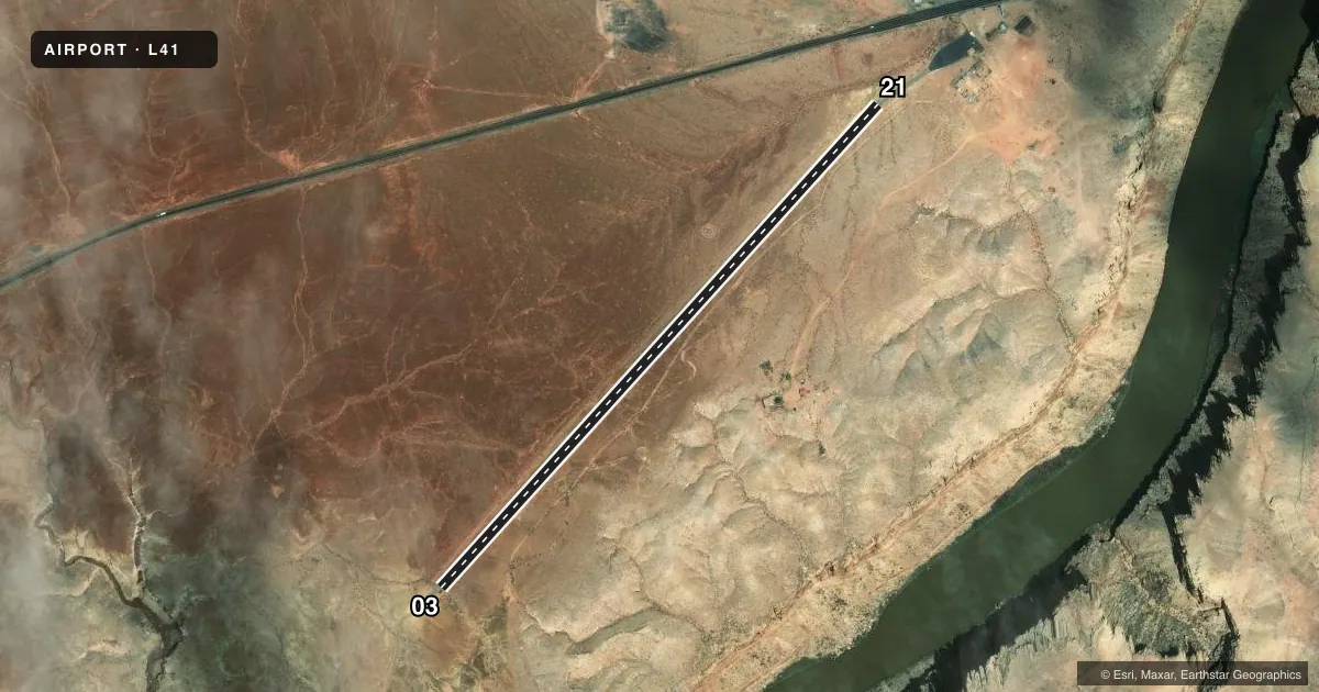
Runways & pattern
Full pagePattern entry · RWY 03
LEFT TRAFFICAirport sketch
Runways drawn to scale from FAA survey coordinates, rendered over satellite imagery. Not for navigation.
Approaches & charts
Services on the field
Fuel grades, oxygen, maintenance, ramp storage and lighting — as declared to the FAA by the airport operator.
Fuel & services
- Fuel
- Not available
Ramp & ground
- Transient storage
- Not published
- Landing fee
- Yes
- Customs
- Not available
- Wind indicator
- Yes
- Segmented circle
- Yes
Fuel & FBOs
Cheapest 100LL and Jet A on the field and nearby. Always confirm with the FBO before taxi.
Airport notes
Surface conditions, obstructions, local procedures, lighting outages and other notes published with each FAA cycle.
General notes
- LINE OF SIGHT BTN RWY ENDS NA.
- CLIFFS W, NW, NE & E.
- MNT CTAF WI 5 NM.
- FOR CD CTC LOS ANGELES ARTCC AT 661-575-2079.
- LNDG FEE; NON HOTEL GUEST TIE DOWN FEE. CAMPING NA.
- ULTRALIGHT, NIGHT OPS NA. COML OPS PPR - AMGR
Runway surface & condition
- 03/21BRUSH ALG BOTH SIDES WI PRIM SFC.
Approach & departure obstructions
- 03+2 FT BRUSH 0-200 FT FM THR 35-100 FT L & R OF CNTRLN.
- 0350:1 CLNC SLOPE TO BGNG OF RESFCD PORTION.
Other notes
- ESTABD PRIOR TO 5/15/59.
- OWNERFRED BROWN
- MANAGERLODGE - 1-928-355-2225.
- 03/21ROUGH & RUTS.
VFR map & nearby airports
VFR sectional. Tap any ICAO chip to open that airport.
Key facts · L41
Answer card- ICAO
- L41
- Name
- MARBLE CANYON
- Location
- MARBLE CANYON, ARIZONA
- Elevation
- 3,603 ft MSL
- Traffic pattern altitude
- 4,603 ft MSL (1,000 AGL)
- Control tower
- Non-towered (use CTAF)
- Total runways
- 1
- Longest runway
- 03/21 · 3,715 ft
- Published ILS approaches
- 0
- Published frequencies
- 1
- Magnetic variation
- –
- Current flight rules
- VFR
- Current wind
- 000° at 3 kt
- Favored runway now
- RWY 03
Marble Canyon Airport sits in Marble Canyon, Arizona. The field elevation is 3,603 ft MSL. It has one runway, 03/21, which is 3,715 ft long and paved. There is no control tower. CTAF is 122.9. No ILS approaches are published here.
Pattern altitude is not published. Use 1,000 ft AGL as the standard light-piston pattern unless the current Chart Supplement or airport operator says otherwise. The field is old. The remarks note it was established before May 15, 1959. They also note rough pavement with ruts on 03/21. Brush is along both sides within the primary surface of runway 03/21. There is also 2-foot brush near the threshold of runway 03, from 0 to 200 feet out. It is 35 to 100 feet left and right of centerline. Line of sight between runway ends is not available.
There are cliffs to the west, northwest, northeast and east. That makes terrain awareness important on arrival and departure. Ultralight, experimental and night operations are not authorized. Commercial operations need prior permission from the airport manager. Landing fees apply. Non-hotel guest tie-down fees apply. Camping is not available. No on-field FBOs are listed, so contact the airport operator directly or the field by phone before you go. For clearance delivery, the remarks direct pilots to Los Angeles ARTCC at 661-575-2079.