METAR & TAF KGNT
Current METAR
Observed 13:35Z
KGNT 271335Z AUTO 16003KT 10SM CLR 20/13 A3032 RMK AO2 T01960130
- Wind
- 160° @ 3 kt
- Visibility
- 10 SM
- Temp / Dew
- 20°C / 13°C
- Altimeter
- 30.32 inHg
- Clouds
- CLR
- Density alt
- 8,210 ft
- Ceiling
- Unlimited
- Rules
- VFR
Airport info & contacts
Manager on record, flight service, ARTCC, attendance schedule and pattern altitude — published by the FAA and refreshed every 28 days.
Location
- From city
- 3 NM NW
- VFR sectional
- ALBUQUERQUE
- ARTCC
- ZAB · ALBUQUERQUE
- NOTAM facility
- GNT (NOTAM-D)
Airport manager
- Name
- LYNN CANNON
- Phone
- 505-287-4700
- Address
- BOX 879, GRANTS NM 87020
Flight service · Hours
- FSS ABQ
- ALBUQUERQUE1-800-WX-BRIEF
- Attendance
- 0800-1700
Frequencies
Tap any row to copy the frequency to your clipboard.
Runways & pattern
Full pagePattern entry · RWY 13
LEFT TRAFFICRunway end performance
| End | TORA | TODA | ASDA | LDA | VGSI | Approach lights | Obstruction |
|---|---|---|---|---|---|---|---|
| 13 | — | — | — | — | PAPI 2-box left(3°) | — | — |
| 31 | — | — | — | — | PAPI 2-box left(3°) | — | — |
Declared distances in feet. TORA = takeoff run available, TODA = takeoff distance, ASDA = accelerate-stop, LDA = landing distance.
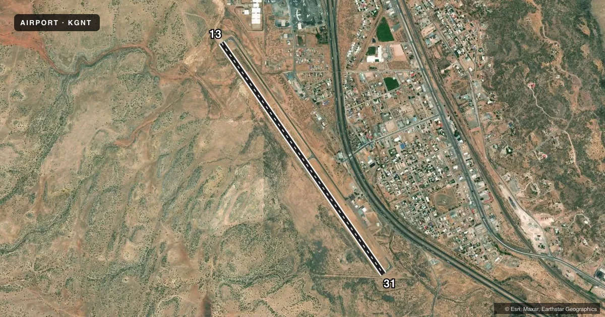
Airport sketch
Runways drawn to scale from FAA survey coordinates, rendered over satellite imagery. Not for navigation.
Approaches & charts
Services on the field
Fuel grades, oxygen, maintenance, ramp storage and lighting — as declared to the FAA by the airport operator.
Fuel & services
- Fuel
- 100LLA1+
- Other services
- AFRT,AMB
Ramp & ground
- Transient storage
- Tie-down
- Hangar
- Landing fee
- No fee published
- Customs
- Not available
- Lighting schedule
- SEE RMK
- Beacon schedule
- SS-SR
- Beacon
- White / Green (civil land)(WG)
- Wind indicator
- Lighted
- Segmented circle
- Yes
Fuel & FBOs
Cheapest 100LL and Jet A on the field and nearby. Always confirm with the FBO before taxi.
Airport notes
Surface conditions, obstructions, local procedures, lighting outages and other notes published with each FAA cycle.
General notes
- FOR CD CTC ALBUQUERQUE ARTCC AT 505-856-4861.
- SELF SVC FUEL WITH CREDIT CARD. JET A TRUCK AVBL. AFT HR CALL OUT FEE - AMGR.
- WILDLIFE ON OR INVOF ARPT.
Lighting notes
- ACTVT MIRL RWY 13/31 - CTAF.
Other notes
- AVBLTY - AMGR.
- 1AFT HR - AMGR.
VFR map & nearby airports
VFR sectional. Tap any ICAO chip to open that airport.
Key facts · KGNT
Answer card- ICAO
- KGNT
- Name
- GRANTS-MILAN MUNI
- Location
- GRANTS, NEW MEXICO
- Elevation
- 6,536.9 ft MSL
- Traffic pattern altitude
- 7,536.9 ft MSL (1,000 AGL)
- Control tower
- Non-towered (use CTAF)
- Total runways
- 1
- Longest runway
- 13/31 · 7,172 ft
- Published ILS approaches
- 0
- Published frequencies
- 2
- Magnetic variation
- 11°
- Current flight rules
- VFR
- Current wind
- 160° at 3 kt
- Favored runway now
- RWY 13
Grants-Milan Muni sits in Grants, New Mexico. The field elevation is 6,536.9 ft MSL. It has one runway, 13/31, which is 7,172 ft long. There is no control tower. CTAF and UNICOM are both 122.8. No ILS approaches are published here.
For pattern work, the published pattern altitude is not listed. Use the standard 1,000 ft AGL for light piston traffic unless the current FAA Chart Supplement says otherwise. That puts the traffic pattern about 7,537 ft MSL based on the field elevation. The runway lighting for 13/31 is medium intensity and is activated by the CTAF.
The on-field FBO is Grants-Milan Municipal Airport. It carries AVGAS 100LL and Jet A. Self-service fuel is available with a credit card. Jet A fuel truck service is also listed. After-hours service is available through the airport manager, though an after-hours call-out fee applies. Wildlife is present on or near the airport, so plan your taxi and takeoff with that in mind. For clearance delivery, contact Albuquerque ARTCC. If you need transient storage or hangar space, check with the airport manager before arrival.