METAR & TAF T16
T16 does not publish a METAR.
Showing the nearest reporting station: KJTC (SPRINGERVILLE MUNI) · 34.8 NM away. Conditions at T16 may differ.
METAR · KJTC
Observed 04:15Z
KJTC 270415Z AUTO 00000KT 10SM CLR 22/14 A3036 RMK AO2
- Wind
- 000° @ 0 kt
- Visibility
- 10 SM
- Temp / Dew
- 22°C / 14°C
- Altimeter
- 30.36 inHg
- Clouds
- CLR
- Density alt
- 8,187 ft
- Ceiling
- Unlimited
- Rules
- VFR
Airport info & contacts
Manager on record, flight service, ARTCC, attendance schedule and pattern altitude — published by the FAA and refreshed every 28 days.
Location
- From city
- 5 NM SW
- VFR sectional
- ALBUQUERQUE
- ARTCC
- ZAB · ALBUQUERQUE
- NOTAM facility
- ABQ (NOTAM-D)
Airport manager
- Name
- DEBRA MAHLER
- Phone
- 575-533-6423
- Address
- PO BOX 507, RESERVE NM 87830
Flight service · Hours
- FSS ABQ
- ALBUQUERQUE1-800-WX-BRIEF
- Attendance
- Unattended
Frequencies
Tap any row to copy the frequency to your clipboard.
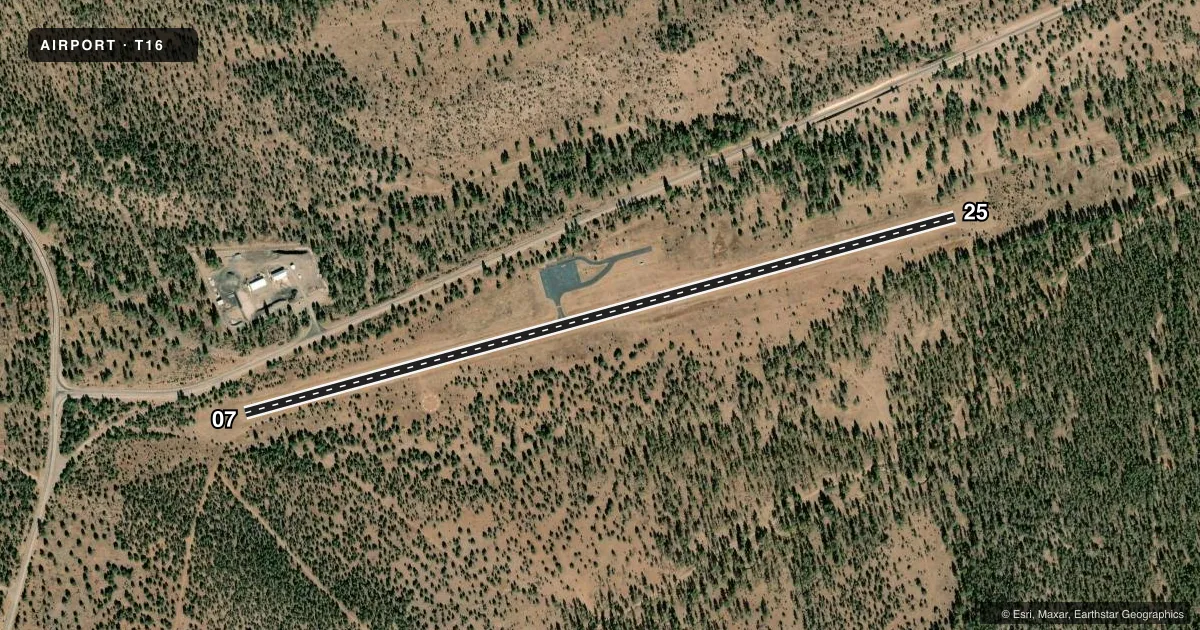
Runways & pattern
Full pagePattern entry · RWY 07
LEFT TRAFFICRunway end performance
| End | TORA | TODA | ASDA | LDA | VGSI | Approach lights | Obstruction |
|---|---|---|---|---|---|---|---|
| 07 | — | — | — | — | — | — | 12', tree, 205' from thr, 85' R of cntrln, slope 0 |
| 25 | — | — | — | — | PSIL(4°) | — | 10', trees, 210' from thr, 15' R of cntrln, slope 1 |
Declared distances in feet. TORA = takeoff run available, TODA = takeoff distance, ASDA = accelerate-stop, LDA = landing distance.
Airport sketch
Runways drawn to scale from FAA survey coordinates, rendered over satellite imagery. Not for navigation.
Approaches & charts
Services on the field
Fuel grades, oxygen, maintenance, ramp storage and lighting — as declared to the FAA by the airport operator.
Fuel & services
- Fuel
- Not available
Ramp & ground
- Transient storage
- Tie-down
- Landing fee
- No fee published
- Customs
- Not available
- Lighting schedule
- SEE RMK
- Beacon schedule
- SS-SR
- Beacon
- White / Green (civil land)(WG)
- Wind indicator
- Lighted
- Segmented circle
- Yes
Fuel & FBOs
Cheapest 100LL and Jet A on the field and nearby. Always confirm with the FBO before taxi.
Airport notes
Surface conditions, obstructions, local procedures, lighting outages and other notes published with each FAA cycle.
General notes
- ELK ON & INVOF ARPT; ARPT FENCED.
- OBSTN LGTS ON MTN PEAKS OTS INDEF.
- ARPT ACCESS CODE 1546.
- FOR CD CTC ALBUQUERQUE ARTCC AT 505-856-4861.
Lighting notes
- ACTVT MIRL RWY 07/25 - CTAF.
Runway surface & condition
- 07/252 PCT W UPSLOPE. TREES BYD BDRY FENCE BOTH SIDES OF RWY PENETRATE TSNT SFC.
Approach & departure obstructions
- 07+4-18 FT BRUSH & TREES 0-200 FT FM RWY END 80-125 FT L OF CNTRLN.
- 25+3-5 FT BRUSH 20-200 FT FM RWY END 0-120 FT L OF CNTRLN.
- 25PSIL OTS INDEF.
- 07EXCEEDS 45 DEG SLOPE
Other notes
- OWNERLEASED CATRON COUNTY.
- MANAGEREMERG - 575-533-6222.
VFR map & nearby airports
VFR sectional. Tap any ICAO chip to open that airport.
Key facts · T16
Answer card- ICAO
- T16
- Name
- RESERVE
- Location
- RESERVE, NEW MEXICO
- Elevation
- 6,364.7 ft MSL
- Traffic pattern altitude
- 7,364.7 ft MSL (1,000 AGL)
- Control tower
- Non-towered (use CTAF)
- Total runways
- 1
- Longest runway
- 07/25 · 4,800 ft
- Published ILS approaches
- 0
- Published frequencies
- 1
- Magnetic variation
- 12°
- Current flight rules
- VFR
- Current wind
- 000° at 0 kt
- Favored runway now
- –
Reserve Airport (T16) sits in Reserve, New Mexico. Field elevation is 6,364.7 ft MSL. The airport has one runway, 07/25, which is 4,800 ft long and asphalt. There is no control tower. CTAF is 122.9. No ILS approaches are published here.
Pattern altitude is not published, so use the standard 1,000 ft AGL for light piston traffic unless the current Chart Supplement says otherwise. At this elevation, performance planning matters. Expect thinner air and a longer takeoff roll than you would see at lower fields. Runway 07/25 has a 2 percent upslope. The published remarks also call out brush and trees near both runway ends. Trees beyond the fence penetrate the transitional surface. The obstacle clearance slope at the runway 07 end exceeds 45 degrees.
There are no on-field FBOs listed. Check with the airport operator or call the field on CTAF for current services before you go. Published remarks also note that medium intensity runway lights are activated on CTAF. The PAPI at the 25 end is out of service indefinitely. Elk are reported on and near the airport, so keep a sharp scan on taxi and final. The airport is leased by Catron County.