METAR & TAF KJTC
Current METAR
Observed 16:35Z
KJTC 271635Z AUTO 34007G12KT 300V010 10SM CLR 28/12 A3036 RMK AO2
- Wind
- 340° @ 7G12 kt
- Visibility
- 10 SM
- Temp / Dew
- 28°C / 12°C
- Altimeter
- 30.36 inHg
- Clouds
- CLR
- Density alt
- 9,763 ft
- Ceiling
- Unlimited
- Rules
- VFR
Airport info & contacts
Manager on record, flight service, ARTCC, attendance schedule and pattern altitude — published by the FAA and refreshed every 28 days.
Location
- From city
- 1 NM WSW
- VFR sectional
- PHOENIX
- ARTCC
- ZAB · ALBUQUERQUE
- NOTAM facility
- PRC (NOTAM-D)
Airport manager
- Name
- TOWN OF SPRINGERVILLE
- Phone
- 928-333-5746
- Address
- 905 WEST AIRPORT RD, SPRINGERVILLE AZ 85938
Flight service · Hours
- FSS PRC
- PRESCOTT1-800-WX-BRIEF
- Attendance
- 0800-1600
Frequencies
Tap any row to copy the frequency to your clipboard.
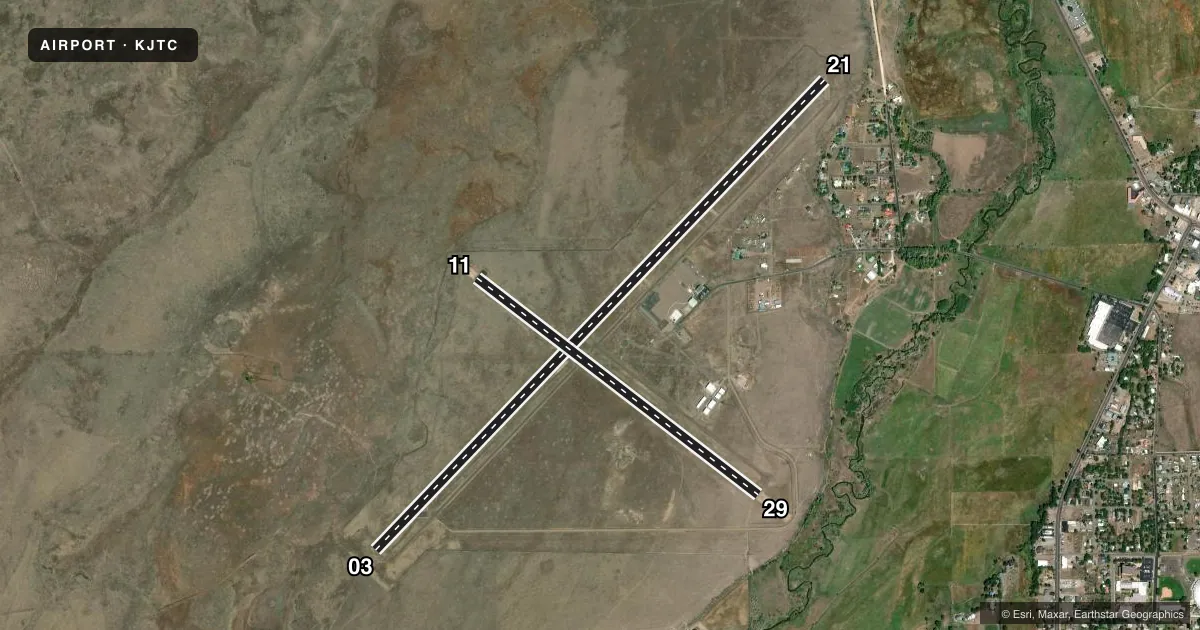
Runways & pattern
Full pagePattern entry · RWY 29
LEFT TRAFFIC| Runway | Heading (°M) | Length | Surface | Traffic |
|---|---|---|---|---|
| 03/21 | 32° / 212° | 8,422 ft | ASPH | 21 R |
| 11/29Favored | 116° / 296° | 4,603 ft | ASPH | Standard L |
Runway end performance
| End | TORA | TODA | ASDA | LDA | VGSI | Approach lights | Obstruction |
|---|---|---|---|---|---|---|---|
| 03 | — | — | — | — | PAPI 2-box left(4°) | — | — |
| 21 | — | — | — | — | PAPI 2-box left(3°) | — | — |
| 11 | — | — | — | — | PAPI 2-box left(3°) | — | — |
Declared distances in feet. TORA = takeoff run available, TODA = takeoff distance, ASDA = accelerate-stop, LDA = landing distance.
Airport sketch
Runways drawn to scale from FAA survey coordinates, rendered over satellite imagery. Not for navigation.
Approaches & charts
Services on the field
Fuel grades, oxygen, maintenance, ramp storage and lighting — as declared to the FAA by the airport operator.
Fuel & services
- Fuel
- 100LLA+
- Other services
- AMB
Ramp & ground
- Transient storage
- Tie-down
- Hangar
- Landing fee
- No fee published
- Customs
- Not available
- Lighting schedule
- SEE RMK
- Beacon schedule
- SS-SR
- Beacon
- White / Green (civil land)(WG)
- Wind indicator
- Lighted
- Segmented circle
- Yes
Fuel & FBOs
Cheapest 100LL and Jet A on the field and nearby. Always confirm with the FBO before taxi.
Airport notes
Surface conditions, obstructions, local procedures, lighting outages and other notes published with each FAA cycle.
General notes
- MIL TFC INVOF ARPT.
- WILDLIFE ON & INVOF ARPT.
- DENSITY INDCR AT FUEL PUMPS.
- FOR CD CTC ALBUQUERQUE ARTCC AT 505-856-4861.
Lighting notes
- ACTVT PAPI RWY 03, 11 & 21; MIRL RWY 03/21 & 11/29 - CTAF: 5 CLICKS ON; 7 CLICKS OFF.
Fuel notes
- 100LLAFT HR - 928-245-0151.
Approach & departure obstructions
- 03PAPI DOES NOT PROVIDE OBSTN CLEARANCE 2 NM BYD THR.
Other notes
- THIS AIRPORT HAS BEEN SURVEYED BY THE NATIONAL GEODETIC SURVEY.
- AVBLTY - AMGR
VFR map & nearby airports
VFR sectional. Tap any ICAO chip to open that airport.
Key facts · KJTC
Answer card- ICAO
- KJTC
- Name
- SPRINGERVILLE MUNI
- Location
- SPRINGERVILLE, ARIZONA
- Elevation
- 7,055.2 ft MSL
- Traffic pattern altitude
- 8,055.2 ft MSL (1,000 AGL)
- Control tower
- Non-towered (use CTAF)
- Total runways
- 2
- Longest runway
- 03/21 · 8,422 ft
- Published ILS approaches
- 0
- Published frequencies
- 2
- Magnetic variation
- 12°
- Current flight rules
- VFR
- Current wind
- 340° at 7 kt
- Favored runway now
- RWY 29
Springerville Muni sits in Springerville, Arizona. The field elevation is 7,055.2 ft MSL, so performance planning matters here. There are 2 asphalt runways. The longest is 8,422 ft on 03/21. No tower is published. CTAF and UNICOM are both 122.8.
No ILS approaches are published. Pattern altitude is not published, so verify the current traffic pattern in the FAA Chart Supplement before arrival. The on-field FBO is Springerville Municipal Airport. It carries 100LL and Jet A. Call ahead for availability. The published remarks also note wildlife on and near the airport. Military traffic is in the vicinity. A density altitude indicator is located at the fuel pumps.
Lighting is pilot-controlled on CTAF. Use 5 clicks to turn on the PAPI and medium intensity runway lights. Use 7 clicks to turn them off. The PAPI on runway 03 does not provide obstacle clearance 2 NM beyond the threshold, so treat that end with care. Clearance delivery is handled through Albuquerque ARTCC. For a mountain airport at this elevation, expect thinner air and longer takeoff rolls. Verify current procedures before you go.