METAR & TAF E94
E94 does not publish a METAR.
Showing the nearest reporting station: KSAD (SAFFORD RGNL/1LT DUANE SPALSBURY FLD) · 48.9 NM away. Conditions at E94 may differ.
METAR · KSAD
Observed 14:51Z
KSAD 271451Z AUTO 31013KT 10SM CLR 33/14 A3001 RMK AO2 SLP094 T03330144 51009
- Wind
- 310° @ 13 kt
- Visibility
- 10 SM
- Temp / Dew
- 33°C / 14°C
- Altimeter
- 30.01 inHg
- Clouds
- CLR
- Density alt
- 8,785 ft
- Ceiling
- Unlimited
- Rules
- VFR
Airport info & contacts
Manager on record, flight service, ARTCC, attendance schedule and pattern altitude — published by the FAA and refreshed every 28 days.
Location
- From city
- 3 NM NE
- VFR sectional
- ALBUQUERQUE
- ARTCC
- ZAB · ALBUQUERQUE
- NOTAM facility
- ABQ (NOTAM-D)
Airport manager
- Name
- DEBRA MAHLER
- Phone
- 575-533-6423
- Address
- PO BOX 507, RESERVE NM 87830
Flight service · Hours
- FSS ABQ
- ALBUQUERQUE1-800-WX-BRIEF
- Attendance
- Unattended
Frequencies
Tap any row to copy the frequency to your clipboard.
Runways & pattern
Full pagePattern entry · RWY 01
LEFT TRAFFICRunway end performance
| End | TORA | TODA | ASDA | LDA | VGSI | Approach lights | Obstruction |
|---|---|---|---|---|---|---|---|
| 01 | — | — | — | — | — | — | 10', tree, 0' from thr, 0' R of cntrln, slope 0 |
| 19 | — | — | — | — | — | — | 5', fence, 0' from thr, 0' R of cntrln, slope 0 |
Declared distances in feet. TORA = takeoff run available, TODA = takeoff distance, ASDA = accelerate-stop, LDA = landing distance.
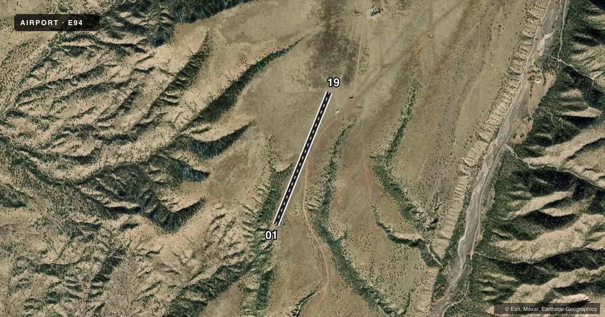
Airport sketch
Runways drawn to scale from FAA survey coordinates, rendered over satellite imagery. Not for navigation.
Approaches & charts
Services on the field
Fuel grades, oxygen, maintenance, ramp storage and lighting — as declared to the FAA by the airport operator.
Fuel & services
- Fuel
- Not available
Ramp & ground
- Transient storage
- Not published
- Landing fee
- No fee published
- Wind indicator
- Yes
- Segmented circle
- No
Fuel & FBOs
Cheapest 100LL and Jet A on the field and nearby. Always confirm with the FBO before taxi.
Airport notes
Surface conditions, obstructions, local procedures, lighting outages and other notes published with each FAA cycle.
General notes
- LIVESTOCK & DEER ON ARPT.
- MTS ALL QUADS.
- N ACES & ACES ROAD UNUSBL AFT RAIN; SIGNS FOR HWY 159 & 174 NA FM HWY 180.
- FOR CD CTC ALBUQUERQUE ARTCC AT 505-856-4861.
Runway surface & condition
- 01/19+4-7 FT BRUSH 40 FT FM RWY CNTRLN BOTH SIDES.
Other notes
- MANAGEREMER PH: CATRON COUNTY SHERIFF'S OFC (575-533-6220).
- 01/19SOFT WHEN WET; LRG ROCKS S 300 FT AT RWY EDGE.
VFR map & nearby airports
VFR sectional. Tap any ICAO chip to open that airport.
Key facts · E94
Answer card- ICAO
- E94
- Name
- GLENWOOD
- Location
- GLENWOOD, NEW MEXICO
- Elevation
- 5,433 ft MSL
- Traffic pattern altitude
- 6,433 ft MSL (1,000 AGL)
- Control tower
- Non-towered (use CTAF)
- Total runways
- 1
- Longest runway
- 01/19 · 3,700 ft
- Published ILS approaches
- 0
- Published frequencies
- 1
- Magnetic variation
- 12°
- Current flight rules
- VFR
- Current wind
- 310° at 13 kt
- Favored runway now
- RWY 01
Glenwood Airport (E94) is in Glenwood, New Mexico. Field elevation is 5,433 ft MSL. The airport has one runway, 01/19, which is 3,700 ft long and surfaced with dirt. There is no control tower. CTAF is 122.9.
No ILS approaches are published here. Pattern altitude is not published, so use the standard 1,000 ft AGL pattern unless the current FAA Chart Supplement says otherwise. That puts the light-piston pattern at about 6,433 ft MSL. The field sits in mountain country. Mountains are in all quadrants. That matters for climb performance, density altitude and terrain clearance on departure and arrival.
Published remarks call out livestock and deer on the airport. The runway surface can get soft when wet. Large rocks are reported south of the runway edge near the 300 ft mark. Brush 4 to 7 ft high is also reported close to both sides of the centerline. North access and the access road are unusable after rain. Signs for Highway 159 and 174 are not available from Highway 180. There are no on-field FBOs listed. Contact the airport operator directly or call the field on CTAF for current local handling details.