METAR & TAF KCFT
KCFT does not publish a METAR.
Showing the nearest reporting station: KSAD (SAFFORD RGNL/1LT DUANE SPALSBURY FLD) · 22.3 NM away. Conditions at KCFT may differ.
METAR · KSAD
Observed 05:51Z
KSAD 270551Z AUTO 29009KT 10SM CLR 32/14 A2999 RMK AO2 SLP088 T03220139 10394 20322 51009
- Wind
- 290° @ 9 kt
- Visibility
- 10 SM
- Temp / Dew
- 32°C / 14°C
- Altimeter
- 29.99 inHg
- Clouds
- CLR
- Density alt
- 6,662 ft
- Ceiling
- Unlimited
- Rules
- VFR
Airport info & contacts
Manager on record, flight service, ARTCC, attendance schedule and pattern altitude — published by the FAA and refreshed every 28 days.
Location
- From city
- 8 NM SE
- VFR sectional
- PHOENIX
- ARTCC
- ZAB · ALBUQUERQUE
- NOTAM facility
- PRC (NOTAM-D)
Airport manager
- Name
- REED LARSON
- Phone
- 928-865-4762
- Address
- PO BOX 908, CLIFTON AZ 85533
Flight service · Hours
- FSS PRC
- PRESCOTT1-800-WX-BRIEF
- Attendance
- UNATTENDED
Frequencies
Tap any row to copy the frequency to your clipboard.
Runways & pattern
Full pagePattern entry · RWY 25
LEFT TRAFFICRunway end performance
| End | TORA | TODA | ASDA | LDA | VGSI | Approach lights | Obstruction |
|---|---|---|---|---|---|---|---|
| 07 | — | — | — | — | PAPI 2-box left(3°) | — | — |
| 25 | — | — | — | — | PAPI 2-box left(3°) | — | — |
Declared distances in feet. TORA = takeoff run available, TODA = takeoff distance, ASDA = accelerate-stop, LDA = landing distance.
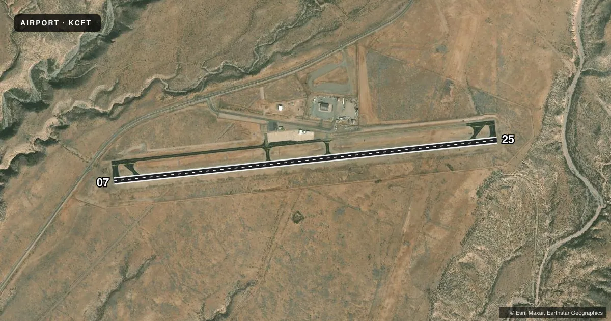
Airport sketch
Runways drawn to scale from FAA survey coordinates, rendered over satellite imagery. Not for navigation.
Approaches & charts
Services on the field
Fuel grades, oxygen, maintenance, ramp storage and lighting — as declared to the FAA by the airport operator.
Fuel & services
- Fuel
- Not available
Ramp & ground
- Transient storage
- Tie-down
- Landing fee
- No fee published
- Customs
- Not available
- Lighting schedule
- SEE RMK
- Beacon schedule
- SS-SR
- Beacon
- White / Green (civil land)(WG)
- Wind indicator
- Lighted
- Segmented circle
- Yes
Fuel & FBOs
Cheapest 100LL and Jet A on the field and nearby. Always confirm with the FBO before taxi.
Airport notes
Surface conditions, obstructions, local procedures, lighting outages and other notes published with each FAA cycle.
General notes
- PAEW MOWING CONS.
- DEER ON OR INVOF ARPT.
- FOR CD CTC ALBUQUERQUE ARTCC AT 505-856-4861.
Lighting notes
- ACTVT MIRL RWY 07/25 - CTAF. PAPI RWY 07 & 25 OPR CONSLY.
Approach & departure obstructions
- 074-6 FT BRUSH 110 FT FM THR, 95 FT L OF CNTRLN.
VFR map & nearby airports
VFR sectional. Tap any ICAO chip to open that airport.
Key facts · KCFT
Answer card- ICAO
- KCFT
- Name
- GREENLEE COUNTY
- Location
- CLIFTON/MORENCI, ARIZONA
- Elevation
- 3,797.8 ft MSL
- Traffic pattern altitude
- 4,797.8 ft MSL (1,000 AGL)
- Control tower
- Non-towered (use CTAF)
- Total runways
- 1
- Longest runway
- 07/25 · 4,978 ft
- Published ILS approaches
- 0
- Published frequencies
- 1
- Magnetic variation
- 10°
- Current flight rules
- VFR
- Current wind
- 290° at 9 kt
- Favored runway now
- RWY 25
Greenlee County Airport (KCFT) serves Clifton and Morenci in eastern Arizona. The field elevation is 3,797.8 ft MSL. It has one runway, 07/25, which is 4,978 ft long and paved. There is no control tower. CTAF is 122.9.
No ILS approaches are published here. The pattern altitude is not published, so use the standard 1,000 ft AGL for light piston operations unless the current FAA Chart Supplement says otherwise. The runway lights on 07/25 are activated by CTAF. The PAPI on both runway ends operates continuously. That helps after dark, but you still want to brief the lighting setup before arrival.
There are no on-field FBOs listed in the facts. Contact the airport operator directly before arrival, or call the field on CTAF for current FBO availability. Published remarks also note deer on or near the airport. Power mowing is in progress. Runway 07 has a brush issue near the threshold, with 4 to 6 ft brush reported 110 ft from the threshold and 95 ft left of centerline. For clearance delivery, contact Albuquerque ARTCC at 505-856-4861. This is a high-elevation field, so plan for density altitude and performance margins.