METAR & TAF KDVT
Current METAR
Observed 10:53Z
KDVT 271053Z AUTO 23005KT 10SM CLR 34/16 A2986 RMK AO2 SLP080 T03390156
- Wind
- 230° @ 5 kt
- Visibility
- 10 SM
- Temp / Dew
- 34°C / 16°C
- Altimeter
- 29.86 inHg
- Clouds
- CLR
- Density alt
- 4,187 ft
- Ceiling
- Unlimited
- Rules
- VFR
Airport info & contacts
Manager on record, flight service, ARTCC, attendance schedule and pattern altitude — published by the FAA and refreshed every 28 days.
Location
- From city
- 15 NM N
- VFR sectional
- PHOENIX
- ARTCC
- ZAB · ALBUQUERQUE
- NOTAM facility
- DVT (NOTAM-D)
Airport manager
- Name
- ED FARON
- Phone
- 623-869-0975
- Address
- 702 W DEER VALLEY DR, PHOENIX AZ 85027
Flight service · Hours
- FSS PRC
- PRESCOTT1-800-WX-BRIEF
- Attendance
- ALL
Frequencies
Tap any row to copy the frequency to your clipboard.
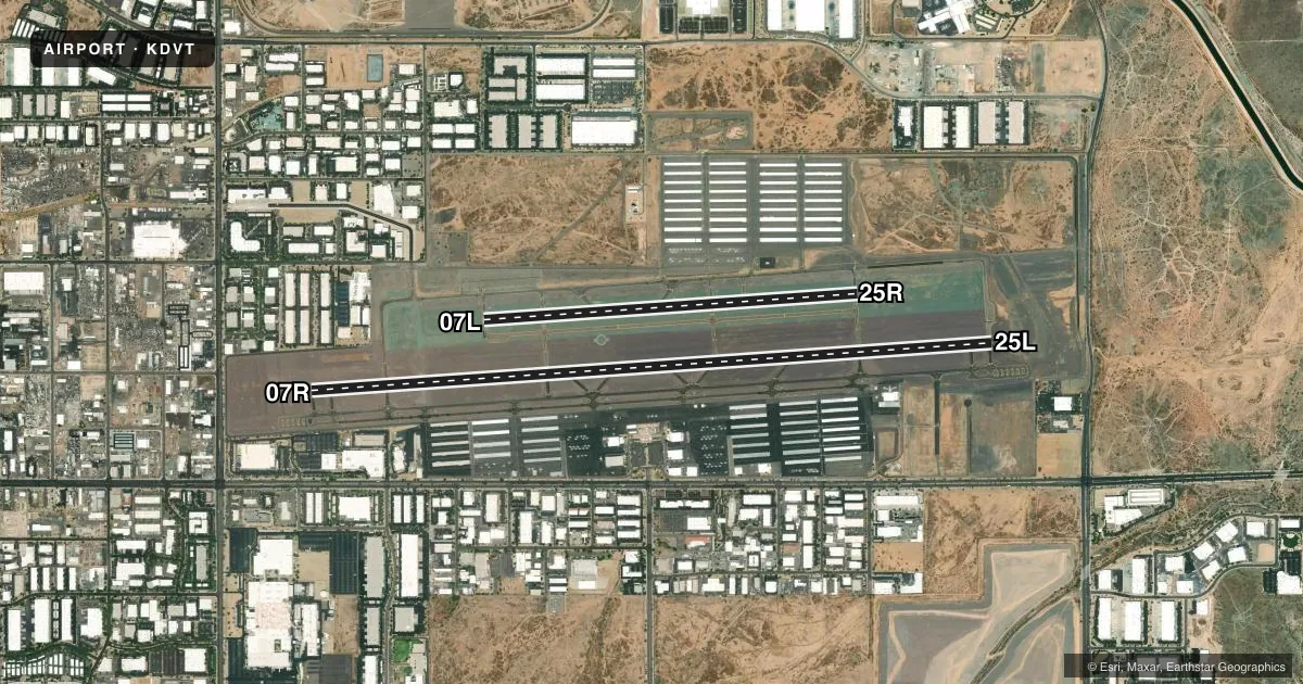
Runways & pattern
Full pagePattern entry · RWY 25L
LEFT TRAFFIC| Runway | Heading (°M) | Length | Surface | Traffic |
|---|---|---|---|---|
| 07R/25LFavored | 74° / 254° | 8,196 ft | ASPH | 07R R |
| 07L/25R | 74° / 254° | 4,500 ft | ASPH | 25R R |
Runway end performance
| End | TORA | TODA | ASDA | LDA | VGSI | Approach lights | Obstruction |
|---|---|---|---|---|---|---|---|
| 07R | 8,196' | 8,196' | 8,196' | 7,299' | PAPI 4-box left(3°) | — | 38', sign, 1257' from thr, 359' R of cntrln, slope 27 |
| 25L | 8,196' | 8,196' | 8,196' | 7,281' | PAPI 4-box left(3°) | — | 76', hill, 2527' from thr, 565' R of cntrln, slope 30 |
| 07L | — | — | — | — | PAPI 4-box left(3.5°) | — | — |
| 25R | — | — | — | — | PAPI 4-box left(4°) | — | 180', hill, 3732' from thr, 122' R of cntrln, slope 19 |
Declared distances in feet. TORA = takeoff run available, TODA = takeoff distance, ASDA = accelerate-stop, LDA = landing distance.
Airport sketch
Runways drawn to scale from FAA survey coordinates, rendered over satellite imagery. Not for navigation.
Approaches & charts
Services on the field
Fuel grades, oxygen, maintenance, ramp storage and lighting — as declared to the FAA by the airport operator.
Fuel & services
- Fuel
- 100LLA+
- Oxygen (bottled)
- High pressure
- Oxygen (bulk)
- High pressure
- Airframe repair
- Major
- Power plant repair
- Major
- Other services
- AMB,AVNCS,CHTR,INSTR,RNTL,SALES
Ramp & ground
- Transient storage
- Tie-down
- Hangar
- Landing fee
- No fee published
- Customs
- Not available
- Lighting schedule
- SEE RMK
- Beacon schedule
- SS-SR
- Beacon
- White / Green (civil land)(WG)
- Wind indicator
- Lighted
- Segmented circle
- Yes
Fuel & FBOs
Cheapest 100LL and Jet A on the field and nearby. Always confirm with the FBO before taxi.
Airport notes
Surface conditions, obstructions, local procedures, lighting outages and other notes published with each FAA cycle.
General notes
- CTN: LGTD HILLS NE, E, SE & W; HOT AIR BLN OPS N, NE & NW; PILOT TRNG WI 20 NM; AEROBATIC PRACTICE AREA 8.5 MI NW; SFC-6000 MSL.
- CHARTER, TRAVEL CLUB & REVENUE ACFT FEE.
- BIRDS & WILDLIFE ON & INVOF ARPT.
- SPL ATC RULE (SATR) IN EFCT W OF ARPT; CK SECTIONAL/TAC.
- TWY D1 & D13 RUNUP PADS CLSD TO WINGSPAN MORE THAN 49 FT.
- FOR CD WHEN ATCT CLSD, CTC PHOENIX APCH AT 602-306-2565.
Lighting notes
- WHEN ATCT CLSD, REIL RWY 07R, 07L, 25R & 25L; PAPI RWY 07R, 07L, 25R & 25L; MIRL RWY 07R/25L & 07L/25R ON CONSLY.
Fuel notes
- 100LLCREDIT CARD SELF SVC AVBL H24.
Runway surface & condition
- 07L/25RTRNG RWY.
Approach & departure obstructions
- 25LUNUSBL BYD 5-DEGS LEFT OF CTRLN AND 6-DEGS RIGHT OF CTRLN.
- 07RAPCH SLOPE 50:1 AT DTHR.
- 25LAPCH SLOPE 50:1 AT DTHR.
Other notes
- TPA-2500 (1022) PISTON ENGINE AND 3000 (1522) TURBINE ENGINE.
- CALL AHEAD FOR AVBLTY - 623-581-1444.
- 1ADMIN - 0600-2100.
- MANAGEREMERG - 623-869-0977.
VFR map & nearby airports
VFR sectional. Tap any ICAO chip to open that airport.
Key facts · KDVT
Answer card- ICAO
- KDVT
- Name
- PHOENIX DEER VALLEY
- Location
- PHOENIX, ARIZONA
- Elevation
- 1,478.1 ft MSL
- Traffic pattern altitude
- 2,478.1 ft MSL (1,000 AGL)
- Control tower
- Towered · 0600-0000
- Total runways
- 2
- Longest runway
- 07R/25L · 8,196 ft
- Published ILS approaches
- 0
- Published frequencies
- 9
- Magnetic variation
- 12°
- Current flight rules
- VFR
- Current wind
- 230° at 5 kt
- Favored runway now
- RWY 25L
Phoenix Deer Valley is in Phoenix, Arizona. The field elevation is 1,478.1 ft MSL. It has two asphalt runways. The longest is 8,196 ft, which is runway 07R/25L. The airport has a control tower. Tower hours are 0600 to 0000. No ILS approaches are published here.
Pattern altitude is not published. Use the standard 1,000 ft AGL for light piston traffic unless the current Chart Supplement or tower gives you a different instruction. The airport sits in busy training airspace. Expect a lot of local traffic. Published remarks call out lighted hills around the airport. They also note balloon activity to the north, northeast and northwest. An aerobatic practice area sits 8.5 NM northwest of the field, from the surface to 6,000 ft MSL. Runway 07L/25R is a training runway. Runway 25L also has a published centerline limitation near the threshold, so brief that before you go.
On the field, SIBRAN Deer Valley carries 100LL. Cutter Aviation carries 100LL and Jet A Prist. Credit card self-serve 100LL is available 24 hours a day. When the tower is closed, lighting is on a pilot-controlled basis for the runway end identifiers, PAPIs and medium intensity runway lights. If you need clearance delivery after tower hours, contact Phoenix Approach. Check the current Chart Supplement for any noise or curfew restrictions before flying into the field.