METAR & TAF KGYR
Current METAR
Observed 12:47Z
KGYR 271247Z 24008KT 10SM CLR 33/19 A2987 RMK FIRST
- Wind
- 240° @ 8 kt
- Visibility
- 10 SM
- Temp / Dew
- 33°C / 19°C
- Altimeter
- 29.87 inHg
- Clouds
- CLR
- Density alt
- 3,424 ft
- Ceiling
- Unlimited
- Rules
- VFR
Airport info & contacts
Manager on record, flight service, ARTCC, attendance schedule and pattern altitude — published by the FAA and refreshed every 28 days.
Location
- From city
- 1 NM SW
- VFR sectional
- PHOENIX
- ARTCC
- ZAB · ALBUQUERQUE
- NOTAM facility
- GYR (NOTAM-D)
Airport manager
- Name
- BRADLEY HAGEN
- Phone
- 623-932-4550
- Address
- 1658 SO LITCHFIELD RD, EXECUTIVE TERMINAL, GOODYEAR AZ 85338
Flight service · Hours
- FSS PRC
- PRESCOTT1-800-WX-BRIEF
- Attendance
- ALL
Frequencies
Tap any row to copy the frequency to your clipboard.
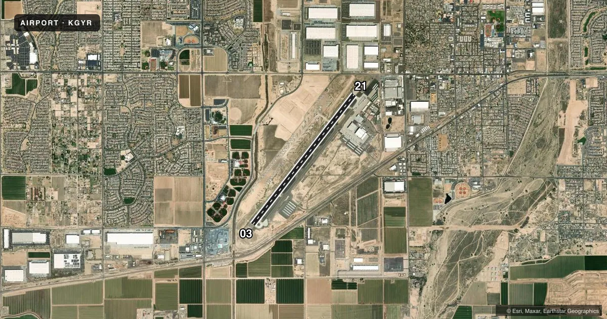
Runways & pattern
Full pagePattern entry · RWY 21
RIGHT TRAFFICRunway end performance
| End | TORA | TODA | ASDA | LDA | VGSI | Approach lights | Obstruction |
|---|---|---|---|---|---|---|---|
| 03 | — | — | — | — | PAPI 4-box left(3°) | — | — |
| 21 | — | — | — | — | PAPI 4-box left(3°) | — | — |
Declared distances in feet. TORA = takeoff run available, TODA = takeoff distance, ASDA = accelerate-stop, LDA = landing distance.
Airport sketch
Runways drawn to scale from FAA survey coordinates, rendered over satellite imagery. Not for navigation.
Approaches & charts
Services on the field
Fuel grades, oxygen, maintenance, ramp storage and lighting — as declared to the FAA by the airport operator.
Fuel & services
- Fuel
- 100LLA
- Oxygen (bottled)
- HIGH/LOW
- Oxygen (bulk)
- HIGH/LOW
- Airframe repair
- Major
- Power plant repair
- Major
- Other services
- INSTR,RNTL
Ramp & ground
- Transient storage
- Tie-down
- Landing fee
- No fee published
- Customs
- Not available
- Lighting schedule
- SEE RMK
- Beacon schedule
- SS-SR
- Beacon
- White / Green (civil land)(WG)
- Wind indicator
- Lighted
- Segmented circle
- Yes
Fuel & FBOs
Cheapest 100LL and Jet A on the field and nearby. Always confirm with the FBO before taxi.
Airport notes
Surface conditions, obstructions, local procedures, lighting outages and other notes published with each FAA cycle.
General notes
- NOISE ABATEMENT PROC IN EFCT; TFC PAT RMN CLOSE TO ARPT & S OF I-10 HWY. TFC N OF I-10 HWY MNTN 1000 FT UNTIL S - INFO 602-773-1093.
- 4500 MSL MTS 6 MI SE; MIL JET TFC 5 MI W; BIRDS INVOF ARPT; WILDLIFE ON ARPT.
- LRG ACFT PRKG 500 FT W OF RWY.
- WHEN TWR CLSD TWY A BTW TWY A3 & A10 RSTD TO WINGSPAN 118 FT OR LESS.
- FOR CD WHEN ATCT CLSD, CTC PHOENIX APCH AT 602-306-2565.
- CTN: SIMILAR ALIGNED RWYS AT LUKE AFB & GLENDALE MUNI; BOTH APRX 8 MI N.
Lighting notes
- SS-SR REIL RWY 03 & 21; PAPI RWY 03 & 21; MIRL RWY 03/21 OPR CONSLY, ALL OTHER TIMES CTC - 623-932-4550.
Runway surface & condition
- H1MED INTSTY.
Approach & departure obstructions
- 03100 FT UNLGT UNMKD E-W PWR LINES 1/2 MI S OF RWY END. DEP ASSIGNED R CROSSWIND CLIMB STRAIGHT AHD TO LITCHFIELD RD OR PASSING 1032 FT BFR R TURN.
Other notes
- OPERATOR TO PRVDD ARPT TFC CTL-PATTERN TO SE AT SPECIFIED ALT. OPNS MUST BE COMPATIBLE WITH OPNS AT LUKE AFB.
- 1968(1000) LIGHT ACFT & NON-TURBO JETS; 2468(1500) HEAVY ACFT & TURBO JETS; HELICOPTERS 1468(500).
- FEE FOR CHARTER, TRAVEL CLUB & REVENUE ACFT.
- INSTRPILOT T.
VFR map & nearby airports
VFR sectional. Tap any ICAO chip to open that airport.
Key facts · KGYR
Answer card- ICAO
- KGYR
- Name
- PHOENIX GOODYEAR
- Location
- GOODYEAR, ARIZONA
- Elevation
- 969.1 ft MSL
- Traffic pattern altitude
- 1,969.1 ft MSL (1,000 AGL)
- Control tower
- Towered · 0600-2100
- Total runways
- 1
- Longest runway
- 03/21 · 8,500 ft
- Published ILS approaches
- 0
- Published frequencies
- 10
- Magnetic variation
- 10°
- Current flight rules
- VFR
- Current wind
- 240° at 8 kt
- Favored runway now
- RWY 21
Phoenix Goodyear is in Goodyear, Arizona, west of Phoenix. The field elevation is 969.1 ft MSL. It has one runway, 03/21, which is 8,500 ft long. The tower is open 0600-2100. No ILS approaches are published here. Light aircraft and non-turbo jets use a pattern altitude of 1,968 ft MSL, which is 1,000 ft AGL. Heavy aircraft and turbo jets use 2,468 ft MSL. Helicopters use 1,468 ft MSL.
Lux Air Jet Centers is on the field. It carries 100LL, Jet A and Jet A Pr. The airport has pilot controlled lighting. Runway end identifier lights, PAPI and medium intensity runway lights on 03/21 are available from sunset to sunrise. Large aircraft parking is 500 ft west of the runway. The airport also has noise abatement in place. Patterns stay close to the airport and south of Interstate 10. Traffic north of I-10 must remain at 1,000 ft until south of the highway. That matters here because Luke Air Force Base and Glendale Municipal Airport are both nearby. They have similarly aligned runways. There are also 100 ft unlighted power lines half a mile south of runway 03. When the tower is closed, clearance delivery goes through Phoenix Approach. Check current procedures before arrival if you are bringing a charter, travel club, or revenue flight.